IFEX daily log
Friday, August 26, 2005
Hurricane Katrina came ashore in South Florida during the evening hours of
Thursday, August 25. The peak winds at landfall were about 75 kt � a Category 1
hurricane. Despite the fact that Katrina was just a minimal hurricane, there was
significant damage to main regions impacted, including downed trees, power outages,
and widespread enormous rainfall amounts (e.g., up to 20 inches estimated by radar at
some locations in Miami-Dade county). A gust of 91 kt was measured at RSMAS on
Virginia Key. The storm took a jog toward the southwest at landfall, bringing the eye
over north Miami-Dade county and through central Miami-Dade as it tracked west-
southwest toward Florida Bay. The storm moved faster than expected and spent less time
over land than expected, emerging into the Gulf of Mexico by 12 UTC Friday.
Because the forecasts had called for Katrina to spend much longer over land, no
flights were tasked for this Friday. Also, the NRL P-3 evacuated to Patuxent River, MD,
in anticipation of possible tropical-storm force winds. For tomorrow, N43RF tasked for a
combination SFMR/fix mission, with fix responsibilities at 15, 18, and 21 UTC. The
plan calls for an attempted coordination between N43RF and the NRL P-3 during this
tasked mission. The coordination will occur during the northwest-oriented downwind leg
of the rotating figure-4 pattern for N43RF, which will be located on the northeast side of
the storm. A slight modification of the standard figure-4 tasked pattern has been sought
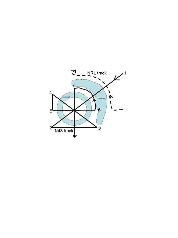 from NHC. This modification involves changing the downwind leg on the northeast side
from a straight line to one that is oriented along the inner edge of the anticipated rainband
(Fig. 33). The NRL P-3 will takeoff from Patuxent River and fly to the storm, recovering
in Tampa at the end of the mission. N42RF is down for continued installation and
integration of the IWRAP instrument.
from NHC. This modification involves changing the downwind leg on the northeast side
from a straight line to one that is oriented along the inner edge of the anticipated rainband
(Fig. 33). The NRL P-3 will takeoff from Patuxent River and fly to the storm, recovering
in Tampa at the end of the mission. N42RF is down for continued installation and
integration of the IWRAP instrument.
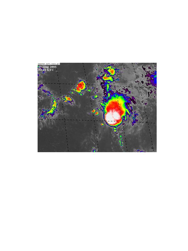
 Katrina continued to move toward the west-southwest and strengthened to a Category 2
hurricane during the afternoon hours. An eye appears to be forming in infrared satellite
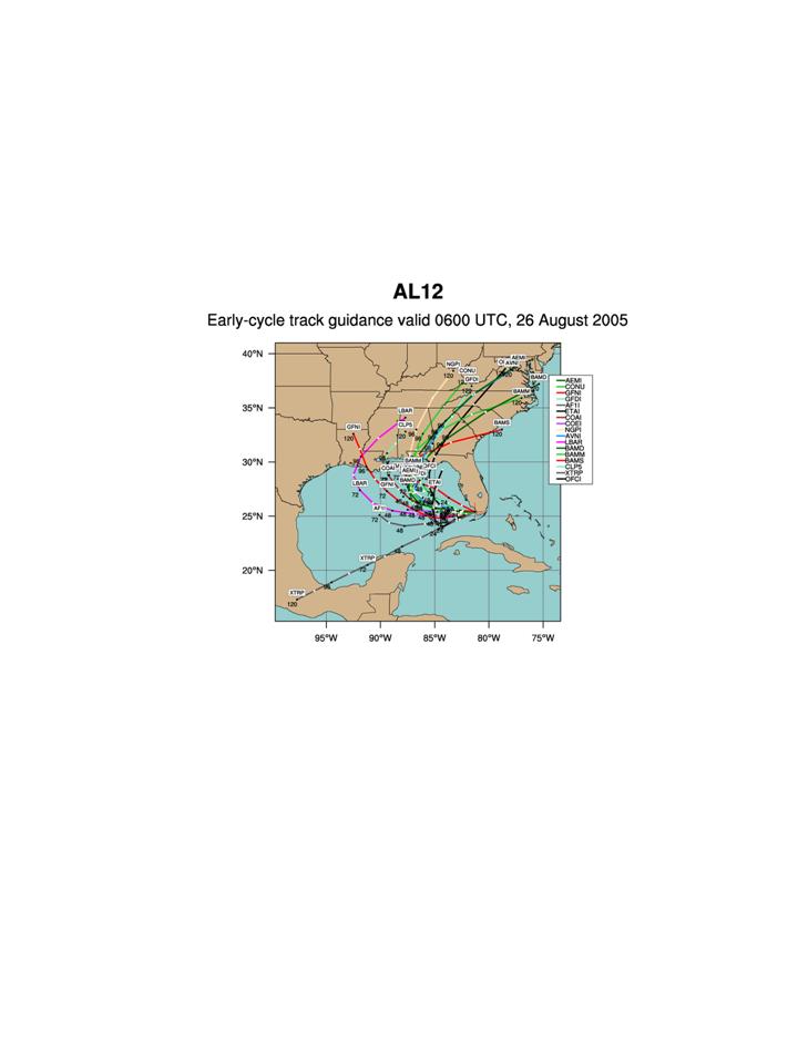
imagery during the evening hours (Fig. 34). Track guidance (Fig. 35) indicates that the
storm is likely to come ashore somewhere between the coast of the Florida panhandle and
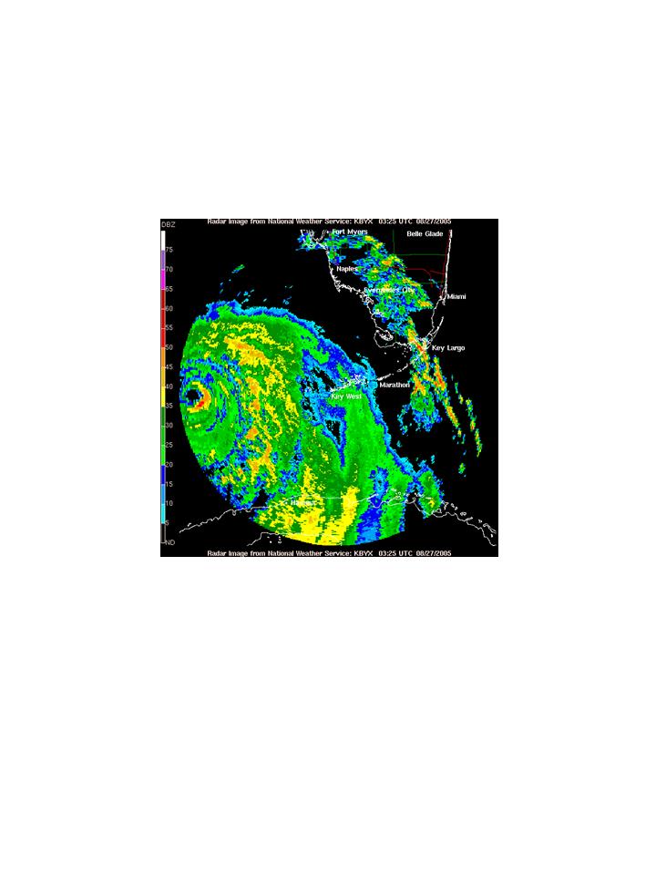
Louisiana on Monday morning. The orientation of convective bands seems to be
changing from a maximum on the southeast side to the east side, as revealed by radar
Katrina continued to move toward the west-southwest and strengthened to a Category 2
hurricane during the afternoon hours. An eye appears to be forming in infrared satellite
imagery during the evening hours (Fig. 34). Track guidance (Fig. 35) indicates that the
storm is likely to come ashore somewhere between the coast of the Florida panhandle and
Louisiana on Monday morning. The orientation of convective bands seems to be
changing from a maximum on the southeast side to the east side, as revealed by radar
 imagery (Fig. 36). It is anticipated that these bands will become oriented along the
northeastern side of the storm tomorrow as the northeasterly shear associated with the
imagery (Fig. 36). It is anticipated that these bands will become oriented along the
northeastern side of the storm tomorrow as the northeasterly shear associated with the
 strong ridge north of Katrina (Fig. 37) relaxes and the orientation of convection becomes
dominated by the motion of the storm. It is during the time that N43RF and the NRL P-3
will be located in the system.
strong ridge north of Katrina (Fig. 37) relaxes and the orientation of convection becomes
dominated by the motion of the storm. It is during the time that N43RF and the NRL P-3
will be located in the system.
 For the following day (Sunday), N43RF is tasked for another SFMR/fix missions,
with fix responsibilities at 18 and 21 UTC. Because only 2 fix times are required, there is
the possibility of having time to work a rainband in coordination with the NRL P-3. This
possibility will be explored as the time approaches. For Monday, a landfall mission may
occur. If NHC does not task the P-3, then a research mission may be flown if the storm is
anticipated to be a major hurricane at landfall.
For the following day (Sunday), N43RF is tasked for another SFMR/fix missions,
with fix responsibilities at 18 and 21 UTC. Because only 2 fix times are required, there is
the possibility of having time to work a rainband in coordination with the NRL P-3. This
possibility will be explored as the time approaches. For Monday, a landfall mission may
occur. If NHC does not task the P-3, then a research mission may be flown if the storm is
anticipated to be a major hurricane at landfall.
 Elsewhere in the Tropics, the tropical wave in the central Atlantic continues to
persist, with a flare-up of convection in the nighttime hours (Fig. 38). Global models
continue to forecast this system, if it develops, to curve toward the north at around 50-55
W, well out of range of possible operations.
Elsewhere in the Tropics, the tropical wave in the central Atlantic continues to
persist, with a flare-up of convection in the nighttime hours (Fig. 38). Global models
continue to forecast this system, if it develops, to curve toward the north at around 50-55
W, well out of range of possible operations.
Rob Rogers
HRD Field Program director
Return to IFEX calendar page


![[OAR/DOC/NOAA Logos]](../../../oar_noaa_doc_logos3.jpg)