Mission Summary
20050715H1 Aircraft 42RF
Genesis Flight
IFEX 2005
Scientific Crew (42RF)
| Lead Project Scientist | Robert Rogers |
| Radar Scientist | Paul Leighton |
| Workstation Scientist | Shirley Murillo |
Aircraft Crew (42RF)
| Pilots | Phil Kennedy
Barry Choy |
| Flight Engineers | Steve Wade |
| Navigators | Tim Gallagher |
| Flight Director | Paul Flaherty |
| Data Engineers | Sean McMillan
John Hill
Mark Rogers |
Mission Plan :
Fly a diamond survey pattern into suspect area in the East Pacific at
about 8 N 87 W. Convection had persisted there for two days along the
northern boundary of the ITCZ. Northeast flow offshore and southwest
flow further out had set up a shear axis or a circulation at the surface.
There are 23 GPS drops and 8 AXBTŐs planned for this flight.
Mission Summary :
 At the morning HRD conference call it was noticed that the area that had
been the target of the previous daysŐ missions remained in an unfavorable
environment, with moderate to strong 20-kt vertical shear in the
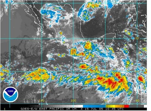
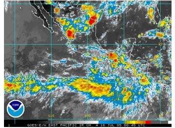
vicinity. To the southeast, infrared imagery (Fig. 1) showed a
widespread area of deep convection just offshore Costa Rica. This
general area had persisted since the previous day and was noticed in the
discussions of the previous day. It had been discounted as being
ITCZ-related convection, but several factors led to the conclusion that
this may be the preferred location for genesis rather than the one being
targeted the previous day. First, the convection was quite persistent.
At the morning HRD conference call it was noticed that the area that had
been the target of the previous daysŐ missions remained in an unfavorable
environment, with moderate to strong 20-kt vertical shear in the
vicinity. To the southeast, infrared imagery (Fig. 1) showed a
widespread area of deep convection just offshore Costa Rica. This
general area had persisted since the previous day and was noticed in the
discussions of the previous day. It had been discounted as being
ITCZ-related convection, but several factors led to the conclusion that
this may be the preferred location for genesis rather than the one being
targeted the previous day. First, the convection was quite persistent.
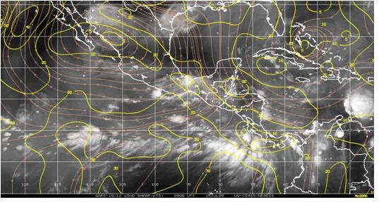 Second, the shear in this environment was more favorable for development
than over the area targeted yesterday (Fig. 2). Shear in the zone that
was targeted yesterday is still about 20 kts today, whereas the area with
the persistent convection has a region of 5-10 kt shear on the northeast
edge of the convection. Third, observations from the N43RF night flight
indicated that there was fairly strong low-level northeasterlies off the west
coast of Costa Rica and Nicaragua and southwesterly flow further out into
the water, indicating a possible shear axis or convergence zone. Fourth,
Second, the shear in this environment was more favorable for development
than over the area targeted yesterday (Fig. 2). Shear in the zone that
was targeted yesterday is still about 20 kts today, whereas the area with
the persistent convection has a region of 5-10 kt shear on the northeast
edge of the convection. Third, observations from the N43RF night flight
indicated that there was fairly strong low-level northeasterlies off the west
coast of Costa Rica and Nicaragua and southwesterly flow further out into
the water, indicating a possible shear axis or convergence zone. Fourth,
 global model forecast ensembles (Fig. 3) began to predict genesis in the
region just west of the deep convection in the next 1-3 days. For these
reasons, we decided to shift our target to the area of deep convection
between about 5 and 10 N and 84 and 90 W.
global model forecast ensembles (Fig. 3) began to predict genesis in the
region just west of the deep convection in the next 1-3 days. For these
reasons, we decided to shift our target to the area of deep convection
between about 5 and 10 N and 84 and 90 W.
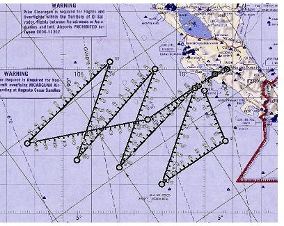 The pattern planned for N42RF (Fig. 4) was a modified diamond pattern
intended to cover the maximum amount of territory as possible. The axis
of the diamond would be oriented along a WNW-ENE axis, roughly aligned
parallel and just to the north of a convergence line suggested by
QuikScat imagery confirmed by a subsequent overpass (Fig. 5). The plan
called for 25 GPS drops and 8 AXBTs to be released (Fig. 6).
The pattern planned for N42RF (Fig. 4) was a modified diamond pattern
intended to cover the maximum amount of territory as possible. The axis
of the diamond would be oriented along a WNW-ENE axis, roughly aligned
parallel and just to the north of a convergence line suggested by
QuikScat imagery confirmed by a subsequent overpass (Fig. 5). The plan
called for 25 GPS drops and 8 AXBTs to be released (Fig. 6).
 Takeoff occurred from San Jose at 1752 UTC. At flight level, there was a
clear cyclonic shear axis or gyre centered roughly at 7.5 N 85.5 W (Fig. 7).
There was some evidence of whitecaps at the surface south of this
feature. It is possible that the feature was developed by the deep
convection that had formed during the previous night, but that is
impossible to say definitively since no aircraft was in this system the
previous night, except for a passby with F/AST imagery by N43RF. There
were large areas of anvil debris throughout much of the flight, and some
areas of stratiform rain with convective elements embedded within them.
There were several areas of near white-out conditions in terms of
visibility due to the presence of stratiform cloud.
During the flight the pattern was modified slightly. The pattern was
changed to cut off the northern tip of the top triangle, and to extend
the southwest end of the pattern to the south and the east. The purpose
of this change was to try to straddle the flight-level cyclonic wind
shift (i.e., to provide more observations in the flight-level southwesterly
flow.)
Takeoff occurred from San Jose at 1752 UTC. At flight level, there was a
clear cyclonic shear axis or gyre centered roughly at 7.5 N 85.5 W (Fig. 7).
There was some evidence of whitecaps at the surface south of this
feature. It is possible that the feature was developed by the deep
convection that had formed during the previous night, but that is
impossible to say definitively since no aircraft was in this system the
previous night, except for a passby with F/AST imagery by N43RF. There
were large areas of anvil debris throughout much of the flight, and some
areas of stratiform rain with convective elements embedded within them.
There were several areas of near white-out conditions in terms of
visibility due to the presence of stratiform cloud.
During the flight the pattern was modified slightly. The pattern was
changed to cut off the northern tip of the top triangle, and to extend
the southwest end of the pattern to the south and the east. The purpose
of this change was to try to straddle the flight-level cyclonic wind
shift (i.e., to provide more observations in the flight-level southwesterly
flow.)
Observations from the flight by N42RF during the day helped to guide the
pattern planning for N43RF. N43RF was planning to fly the square-spiral
pattern, and had asked N42RF for a centroid for the pattern. Based on
flight-level observations of the cyclonic wind shift/gyre, N42RF
identified the center as being at 7.5 N 86 W. Assuming a movement of 6
degrees/day, that made for a motion of 3 degrees over a 12-h period. This
seemed awfully fast, so an assumed motion of 1.5 degrees was made for the
system. That put the centroid at 7.5 N 87.5 W at the time N43RF will be
in the pattern. The square-spiral pattern covers about 3 degrees of
area, and takes about 3.5 to 4 h to execute. Since the ferry for this
mission will be so short, the size of the pattern can be expanded if
necessary. Upon further inspection of the flight-level winds, it
appeared that a fairly clearly-defined wave is evident, with an axis at
about 87 or 88 W. That boded well for possible future development, since
there was a forcing mechanism (i.e., the wave) and the environment was
favorable (i.e., relatively low shear and low-level convergence
associated with strong southwesterly flow at the surface). Surface winds
were strong southwesterlies throughout the region, with magnitudes as
high as 25 kt.
 By the end of the flight (landing at 0222 UTC), infrared imagery (Fig.
8) showed widespread ITCZ convection at about 8 N 100 W and areas of
convection in the target region around 8 N 88 W. The cloud patterns
further west continue to show striations oriented NE-SW, suggesting a
fair amount of northeasterly shear over that area, while the cloud
patterns in the target area show much less evidence of experiencing
shear, even though the amount of cold cloud tops is less than that
further west. That may be normal, though, since the typical diurnal
cycle is governed by little convection during the day and a blossoming of
convection during the overnight hours. This is why it will be so
important for N43RF to fly into the region tonight, and then for N42RF to
fly into the same target the following day, to document the changes to
the atmosphere that arose as a result of the convective heating.
By the end of the flight (landing at 0222 UTC), infrared imagery (Fig.
8) showed widespread ITCZ convection at about 8 N 100 W and areas of
convection in the target region around 8 N 88 W. The cloud patterns
further west continue to show striations oriented NE-SW, suggesting a
fair amount of northeasterly shear over that area, while the cloud
patterns in the target area show much less evidence of experiencing
shear, even though the amount of cold cloud tops is less than that
further west. That may be normal, though, since the typical diurnal
cycle is governed by little convection during the day and a blossoming of
convection during the overnight hours. This is why it will be so
important for N43RF to fly into the region tonight, and then for N42RF to
fly into the same target the following day, to document the changes to
the atmosphere that arose as a result of the convective heating.
Problems :
The dropsondes continued to occasionally give probems. There were 7 no
launch detects. Otherwise things worked well.
Data :
Radar coverage
| Start
| End
|
| 17:57:59 Z
| 02:11:59 Z
|
Page last updated August 5, 2005
Return to Mission page.