Mission Summary 20010923H
Hurricane Humberto
COVES experiment
Aircraft: N42RF
PDF version
|
Scientific Crew
|
| Lead Project Scientist | Frank Marks
|
| Cloud Physics Scientist | Bob Black
|
| Radar/Workstation Scientist | John Gamache
|
| GPS sonde Scientist | Chris Landsea
|
| CCN scientist | Jim Hudson (DRI)
|
|
Aircraft Crew
|
| Pilots | Tennesen, Taggert
|
| Flight Engineer | Bast, Curry
|
| Navigator | Newman
|
| Flight Director | Damiano
|
| Engineers | McMillan, Delgado, Rogers
|
Table 1
Storm center locations
|
Time
(UTC)
| Latitude
| Longitude
| Central Pressure
(hPa)
| Maximum wind
(kt)
|
| 1800 | 31.92 | -67.35 | |
|
| 1916 | 32.16 | -67.34 | 983 |
|
| 2027 | 32.34 | -67.26 | 983 |
|
| 2158 | 32.51 | -67.10 | 982
|
| 2320 | 32.80 | -67.05 | 981 | 85
|
- Penetrations: 3
- Expendables:
- 48 GPS-sondes,5 bad (2 no launch detect and 3 no winds)
- 18 AXBTs,3 bad
- Tapes
- 4 video tapes
- 1 flight level DAT
- 1 radar DAT
- 1 Cloud Physics DAT
MISSION BRIEF:
 HRD scheduled a Coordinated Observations of Vortex Evolution and
Structure (COVES) mission into Tropical Storm (soon to be
Hurricane) Humberto with N42RF, N43RF, and the NASA DC-8 and
ER-2 aircraft for 23 September 2001. N42RF and N43RF would take
off at 1700 UTC from MacDill AFB and recover in Wilmington, NC.
The NASA aircraft would take off at 1730 UTC from Jacksonville.
All four aircraft would do a coordinated pattern in the core of
Humberto as described in the Hufficane Field Program Plan (HFP)
Fig. 3, while N49RF would fly a surveillance
pattern around the storm. The DC-8 and ER-2 would fly a butterfly
pattern with six 218 nm radial legs from the center at 37000 ft
and 65000 ft, respectively. N43RF would do a similar butterfly
pattern with 108 mn radius legs at 6000 ft, while N42RF would do
a similar butterfly pattern with 135 nm radial legs at
14000-17000 ft, but rotated 90° upwind of N43RF, DC-8 and
ER-2 pattern (see Fig. 1). See
Fig. 2 for the GPS-sonde and AXBT drop
locations. N43RF would do eye fixes and GPS-sonde drops in the
center on the first and third passes and N42RF would fix the
center and drop a GPS sonde on the second pass through the
center. All legs would be coordinated in time with leg lengths
adjusted to keep time coordination. N42RF would be in charge of
maintaining aircraft coordination, passing estimated center
locations to the other aircraft 30 min before reaching the
beginning of the next leg across the storm.
HRD scheduled a Coordinated Observations of Vortex Evolution and
Structure (COVES) mission into Tropical Storm (soon to be
Hurricane) Humberto with N42RF, N43RF, and the NASA DC-8 and
ER-2 aircraft for 23 September 2001. N42RF and N43RF would take
off at 1700 UTC from MacDill AFB and recover in Wilmington, NC.
The NASA aircraft would take off at 1730 UTC from Jacksonville.
All four aircraft would do a coordinated pattern in the core of
Humberto as described in the Hufficane Field Program Plan (HFP)
Fig. 3, while N49RF would fly a surveillance
pattern around the storm. The DC-8 and ER-2 would fly a butterfly
pattern with six 218 nm radial legs from the center at 37000 ft
and 65000 ft, respectively. N43RF would do a similar butterfly
pattern with 108 mn radius legs at 6000 ft, while N42RF would do
a similar butterfly pattern with 135 nm radial legs at
14000-17000 ft, but rotated 90° upwind of N43RF, DC-8 and
ER-2 pattern (see Fig. 1). See
Fig. 2 for the GPS-sonde and AXBT drop
locations. N43RF would do eye fixes and GPS-sonde drops in the
center on the first and third passes and N42RF would fix the
center and drop a GPS sonde on the second pass through the
center. All legs would be coordinated in time with leg lengths
adjusted to keep time coordination. N42RF would be in charge of
maintaining aircraft coordination, passing estimated center
locations to the other aircraft 30 min before reaching the
beginning of the next leg across the storm.
MISSION SYNOPSIS:
 N42RF departed MacDill AFB at 1709 UTC. We checked communications
with N43RF at 1737 UTC as we passed off the east coast of Florida.
At 1810 UTC we found out that N49RF had a mechanical problem and
would be delayed by 2 h. Over the next hour of transit we realized
we would have a problem with AXBT drops as both aircraft had the
same mix of channels to drop (Channel 12 and 16). So Barry
Damiano contacted Stan Czyzyk to arrange for each aircraft to
drop different channels on each leg to avoid interference. At
1845 UTC we established communication with the two NASA aircraft.
At 1925 UTC we received the last AFRES fix and adjusted the IP
for all of the aircraft to reflect the new position (see Table
1). We also leamed that the DC-8 was having a problem getting
airspace clearance and was starting their first leg at 28000 ft.
We decided to descend from 17000 ft to 14,000 ft when we were
within 60 nmi of the core to avoid lightning and graupel.
N42RF departed MacDill AFB at 1709 UTC. We checked communications
with N43RF at 1737 UTC as we passed off the east coast of Florida.
At 1810 UTC we found out that N49RF had a mechanical problem and
would be delayed by 2 h. Over the next hour of transit we realized
we would have a problem with AXBT drops as both aircraft had the
same mix of channels to drop (Channel 12 and 16). So Barry
Damiano contacted Stan Czyzyk to arrange for each aircraft to
drop different channels on each leg to avoid interference. At
1845 UTC we established communication with the two NASA aircraft.
At 1925 UTC we received the last AFRES fix and adjusted the IP
for all of the aircraft to reflect the new position (see Table
1). We also leamed that the DC-8 was having a problem getting
airspace clearance and was starting their first leg at 28000 ft.
We decided to descend from 17000 ft to 14,000 ft when we were
within 60 nmi of the core to avoid lightning and graupel.
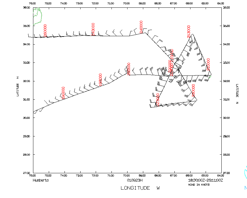
 We reached our IP, 135 nmiwest of the center, at 2000 UTC and
dropped a GPS sonde as we headed east to the center. As we
proceeded eastward we dropped sondes according to the plan (
Fig. 2). As we tracked toward the center the radar suggested the
center was open to the south and had a diameter of about 22 nmi
(Fig. 3). We also noted some very intense reflectivity exceeding
50 dBZ in the NE eyewall, indicative of graupel (Fig. 4). At
2016 UTC we started our descent to 14000 ft 54 nmi from the
center as we entered the first rainband. We reached 14000 ft by
the next drop location at 2018 UTC. At 2025 UTC we passed
through the west eyewall dropping a GPS sonde where the
SFMR-estimated surface wind was 82 kt. We passed the wind center
at 2027 UTC making a visual siting of N43RF as they passed below
us. The NASA aircraft passed through the center within 2 minutes
of the two WP-3D aircraft. The DC-8 got permission to climb to
39000 ft (they couldn't get clearance to fly between 28000-39000
ft) and started their climb on the way out through the north
eyewall. We also leamed that the ER-2 pilot had received no
launch indication for the first two GPS sondes. He was concemed
that the mechanism was jammed, so he planned one more attempt
before deciding to stop launching altogether (it turned out to
be a faulty indicator and the sondes were launched successfully).
After passing out of the eyewall region we passed the estimated
center location to all the aircraft for the second pass through
the center. We climbed back to 17000 ft at 2037 UTC 54 nmi east
of the center. We proceeded east dropping GPS sondes and AXBTs
following the plan (Fig. 2) and reached our eastmost point (2)
at 2056 UTC. (2) was right over Bermuda so no GPS-sonde was
dropped over the island as they launch a 0000 UTC radiosonde. We
turned and tracked through a large stratiform region and rainbands
toward (3) 135 nmiNNE of the center, reaching (3) at 2121 UTC.
At (3) we insured all aircraft were at their starting points for
the next leg through the storrn.
We reached our IP, 135 nmiwest of the center, at 2000 UTC and
dropped a GPS sonde as we headed east to the center. As we
proceeded eastward we dropped sondes according to the plan (
Fig. 2). As we tracked toward the center the radar suggested the
center was open to the south and had a diameter of about 22 nmi
(Fig. 3). We also noted some very intense reflectivity exceeding
50 dBZ in the NE eyewall, indicative of graupel (Fig. 4). At
2016 UTC we started our descent to 14000 ft 54 nmi from the
center as we entered the first rainband. We reached 14000 ft by
the next drop location at 2018 UTC. At 2025 UTC we passed
through the west eyewall dropping a GPS sonde where the
SFMR-estimated surface wind was 82 kt. We passed the wind center
at 2027 UTC making a visual siting of N43RF as they passed below
us. The NASA aircraft passed through the center within 2 minutes
of the two WP-3D aircraft. The DC-8 got permission to climb to
39000 ft (they couldn't get clearance to fly between 28000-39000
ft) and started their climb on the way out through the north
eyewall. We also leamed that the ER-2 pilot had received no
launch indication for the first two GPS sondes. He was concemed
that the mechanism was jammed, so he planned one more attempt
before deciding to stop launching altogether (it turned out to
be a faulty indicator and the sondes were launched successfully).
After passing out of the eyewall region we passed the estimated
center location to all the aircraft for the second pass through
the center. We climbed back to 17000 ft at 2037 UTC 54 nmi east
of the center. We proceeded east dropping GPS sondes and AXBTs
following the plan (Fig. 2) and reached our eastmost point (2)
at 2056 UTC. (2) was right over Bermuda so no GPS-sonde was
dropped over the island as they launch a 0000 UTC radiosonde. We
turned and tracked through a large stratiform region and rainbands
toward (3) 135 nmiNNE of the center, reaching (3) at 2121 UTC.
At (3) we insured all aircraft were at their starting points for
the next leg through the storrn.
At (3) we turned and tracked 210° toward the center dropping GPS
sondes and AXBTs as in Fig. 2. We were in heavy precipitation
and the pilots chose to descend to 14000 ft at 2134 UTC roughly
120 nmi from the center. We were in a region of a very strong
bright band around 2139 UTC just outside a very intense rainband
with scalloped cores (as in Bonnie) about 100 run from the
center. At 2142 UTC we crossed the rainband cores. Fortunately,
after we got through this band the radar froze for about 5 min,
coming back just before we penetrated the NNE eyewall at 2156
UTC. Going through the eyewall there were cores of >50 dBZ
reflectivity, lightning, and graupel. We fixed the center at
2157 UTC dropping a sonde in the center, which had no winds, but
a surface pressure of 983 hPa. We saw N43RF pass undemeath us
once again and our sonde splashed within I nmi of their fix
location. The NASA aircraft hit the center at different times
but within 2-3 min of the WP-3D aircraft. We proceeded out of
the open side of the eyewall under a large anvil with mamatus
and virga hanging down to our altitude. The ride through the SSW
eyewall was choppy and we noted increased white caps on the
ocean below us. After passing out of the eyewall region we
passed the estimated center location to all the aircraft for the
third and last pass through the center. We proceeded SSW
dropping sondes and AXBTs as in Fig. 2, climbing back to 17000
ft roughly 80 nmifrom the center. We proceeded in the clear to
(4) 135 nmi SSW of the center arriving there at 2226 UTC. Jim
Hudson reported that the air near (4) was the dirtiest he
encountered on the flight. We turned east to (5) arriving at 2258
UTC and turned inbound for our last pass through the center.
 Our leg from the SSE to the center passed through mostly clear
air. At 2318 UTC, roughly 60 nmi from the center, we descended
to 14000 ft as the anvil descended to our altitude and we
proceeded into the center through the mamatus and virga once
again. The SFMR estimated the surface wind SSE of the center was
87 kt despite the lack of an eyewall on that side. As we crossed
into the eye Jim Hudson reported a sharp decrease in the CN
concentration (20 per liter). It was dark on this pass, but we
did see N43RF's lights pass below us in the center. We proceeded
through the strongest reflectivity in the NNW eyewall at 2329
UTC, noting lightning in the NE eyewall. Just through the
eyewall we hit an intense graupel shower at 2332 UTC (removed
some paint off of the leading edges and props), which presented
a phenomenal visual display of static discharge on the cockpit
windscreen (like blue fireflys). We climbed back up to 17000 ft
at 2339 UTC roughly 70 nmi from the center as we exited the
rainbands NNW of the center. We proceeded to (6) 135 nmi NNW of
the center dropping GPS sondes and AXBTs according to Fig. 2
reaching the end of the pattern at 2357 UTC. At this point the
pilots took over the flight and routed us back to Wilmington,
NC. Along the way we dropped the last AXBT at 2359 UTC about 140
nmi from the center. We landed in Wilmington at 0 132 UTC 24
September.
Our leg from the SSE to the center passed through mostly clear
air. At 2318 UTC, roughly 60 nmi from the center, we descended
to 14000 ft as the anvil descended to our altitude and we
proceeded into the center through the mamatus and virga once
again. The SFMR estimated the surface wind SSE of the center was
87 kt despite the lack of an eyewall on that side. As we crossed
into the eye Jim Hudson reported a sharp decrease in the CN
concentration (20 per liter). It was dark on this pass, but we
did see N43RF's lights pass below us in the center. We proceeded
through the strongest reflectivity in the NNW eyewall at 2329
UTC, noting lightning in the NE eyewall. Just through the
eyewall we hit an intense graupel shower at 2332 UTC (removed
some paint off of the leading edges and props), which presented
a phenomenal visual display of static discharge on the cockpit
windscreen (like blue fireflys). We climbed back up to 17000 ft
at 2339 UTC roughly 70 nmi from the center as we exited the
rainbands NNW of the center. We proceeded to (6) 135 nmi NNW of
the center dropping GPS sondes and AXBTs according to Fig. 2
reaching the end of the pattern at 2357 UTC. At this point the
pilots took over the flight and routed us back to Wilmington,
NC. Along the way we dropped the last AXBT at 2359 UTC about 140
nmi from the center. We landed in Wilmington at 0 132 UTC 24
September.
SUMMARY :
Overall a very good mission! One down and one more to go! Great
coordination with N43RF, DC- 8, and ER-2 by the N42RF crew
(primarily Carl Newman and Barry Damiano). We completed the
pattern as briefed with a few wrinkles to maintain coordination
with the other aircraft and flight safety. We didn't drop a
sonde at the farthest east point because it was over Bermuda and
would be covered by their 0000 UTC radiosonde. We descended to
14000 ft altitude within 50-80 nmiof the center to insure we
stayed out of static discharges and heavy graupel (much to the
constemation of Bob Black). However, that didn't seem to
guarantee success as we ran into a heavy graupel shower on our
last pass through the north eyewall, which had intense (>50
dBZ) reflectivity most of the time we were in the storm.
The storm was apparently sheared from the SW to the NE and had a
very evident tilt to the eyewall convection. It resembled
Hurricane Olivia on 25 September 1994 in appearance, with the
strongest reflectivity on the north side of the storm and a
large region of stratiform precipitation extending 150-200 nmi
NE of the center. There also appeared to be a clear wave #2
asymmetry in the eyewall shape. There was a strong rainband
70-100 nmi NE of the center that contained scalloped cores
similar to those we sampled in Hurricane Bonnie near landfall.
They may contain mesocyclone signatures embedded in the strong
winds. We had some of our worst bumps passing through that band
and we experience the most intense bright-band just radially
outward from the band. The HVPS seemed to work the best it had
all year thanks to Bob Black's and Sean McMillen's constant
attention. Unfortunately, it didn't work when we penetrated the
intense graupel shower on the last leg through the NNW eyewall.
The GPS-sonde coverage from the combined aircraft was
phenomenal. Figures 6 and 7 show the sonde distribution around
the storm from the three NOAA aircraft and the two WP-3D
aircraft, respectively. Adding in the sondes from the ER-2 (3)
and DC-8 (24) it represents the most complete three-dimensional
mapping of any storm in history (over 110 GPS sondes alone). It
will provide data for model simulations, both operational and
new higher resolution research models. Unfortunately, most of
the operational models can't utilize such a high density of
GPSsonde coverage. However, the data set should set the standard
for all future tropical cyclone model development.
In contrast to Erin, the CN measurements indicated that the eye
was relatively clean with concentrations -20 1-1. Jim Hudson
reported the dirtiest air was 100-200 nmi south of the
circulation center. Jim also pointed out that he was seeing
pretty dramatic radial gradient on the CN and CCN concentrations
altemating between relatively dirty and clean air. These data
are going to be fascinating to analyze in the context of the
other observations.
PROBLEMS:
- No King liquid water probe, broken wire.
- Had to juggle AXBT launches with N43RF as we both had a
similar mix of channel 12 and 16 sondes. The coordination went
really well thanks to the two flight directors (Damiano and
Czyzyk).
- ER-2 had drop indicator problems and decided not to drop any
GPS sondes after the first three (turned out the drops worked
fine, it was just a faulty indicator light). DC-8 tried to pick
up missing ER-2 drops.
- DC-8 had a major clearance problem. They couldn't fly
between 28000 and 39000 ft because of ATC. So on the first leg
they started at 28000 ft and passing through north eyewall they
climbed to 39,000 ft and stayed there for the rest of the flight.
Frank Marks
7 October 2001
Table 2
GPS-sondes dropped during mission and their splash locations
|
| Number
| Sonde ID
| TIME
(UTC)
| Latitude
| Longitude
| 150-m
wind
| DLM
wind
| MBL
wind
| Comments
|
| 1 | 003438003 | 1959 | 32.28 | -69.84 | 36017 | 36021 | 01017 | IP
|
| 2 | 003438032 | 2004 | 32.29 | -69.44 | 01519 | 00525 | 01519
|
| 3 | 003438053 | 2010 | 32.30 | -68.92 | 36024 | 00529 | 36025
|
| 4 | 003338085 | 2012 | 32.29 | -68.66 | 36029 | 00534 | 00529
|
| 5 | 003148152 | 2015 | 32.26 | -68.37 | 36036 | 36037 | 01038 | SST 27.2
|
| 6 | 003115065 | 2018 | 32.22 | -68.12 | 35036 | 36040 | 35542 | RAINBAND
|
| 7 | 003338035 | 2021 | 32.20 | -67.84 | -999 | 36049 | -999 | RAINBAND
|
| 8 | | 2025 | 32.20 | -67.51 | -999 | -999 | -999 | No wind EYEWALL 270
|
| 9 | | 2031 | 32.30 | -67.00 | -999 | -999 | -999 | No wind EYEWALL 090
|
| 10 | 011378107 | 2034 | 32.39 | -66.72 | 15062 | 17570 | 16070 | AXBT bad
|
| 11 | 011378103 | 2037 | 32.38 | -66.45 | 16049 | 17556 | 16053
|
| 12 | 010715169 | 2040 | 32.38 | -66.20 | 15545 | 17551 | 15548 | SST 27.2
|
| 13 | 011245188 | 2043 | 32.38 | -65.91 | 15538 | 17547 | 16043
|
| 14 | 011245375 | 2046 | 32.38 | -65.64 | 16035 | 17543 | 16042 | SST 27.0
|
| 15 | 003338032 | 2052 | 32.38 | -65.12 | 13531 | 17039 | 14036 | No AXBT, near Bermuda (2)
|
| 17 | 003475095 | 2133 | 34.13 | -66.20 | 08024 | 11526 | 09025 | RAINBAND SST 26.1
|
| 18 | 011345110 | 2139 | 33.73 | -66.48 | 07530 | 10537 | 08034 | RAINBAND AXBT bad
|
| 19 | 011315007 | 2143 | 33.55 | -66.61 | 07037 | 11543 | 08041 | RAINBAND
|
| 20 | 011245373 | 2146 | 33.34 | -66.76 | 06535 | 10544 | 07039 | RAINBAND AXBT bad
|
| 21 | | 2149 | 33.13 | -66.83 | -999 | -999 | -999 | No launch detect
|
| 22 | 011245409 | 2152 | 32.96 | -67.08 | 06558 | 10059 | 07560 | RAINBAND
|
| 23 | 003515038 | 2156 | 32.68 | -67.23 | 01581 | 07059 | 02589 | EYEWALL 030
|
| 24 | 011245423 | 2157 | 32.60 | -67.10 | -999 | -999 | -999 | EYE No Winds
|
| 25 | 011315008 | 2202 | 32.29 | -67.21 | 29569 | 30573 | 30579 | EYEWALL 210
|
| 26 011345108 | 2205 | 32.09 | -67.33 | 29535 | 29545 | 30542
|
| 27 | 011378110 | 2209 | 31.89 | -67.46 | -999 | -999 | -999 | No wind
|
| 28 | 011245022 | 2211 | 31.69 | -67.58 | 27526 | 29530 | 28029 | SST 26.2
|
| 29 | 011335044 | 2214 | 31.48 | -67.71 | 28026 | 29527 | 28527
|
| 30 | 011315006 | 2218 | 31.30 | -67.90 | -999 | -999 | -999 | No Wind
|
| 31 | 003115281 | 2223 | 30.89 | -68.09 | 30016 | 30519 | 30017
|
| 32 | 011378105 | 2226 | 30.63 | -68.23 | 30014 | 31016 | 30015 | (4)
|
| 33 | 003135322 | 2256 | 30.97 | -65.57 | 20522 | 21028 | 21024 | (5)
|
| 34 | 004255073 | 2302 | 31.37 | -65.82 | 20527 | 21031 | 21028 | SST 27.5
|
| 35 | 003115195 | 2308 | 31.80 | -66.06 | 20532 | 21037 | 20534 | LST WND 017
|
| 36 | | 2312 | 31.90 | -66.23 | -999 | -999 | -999 | No launch detect
|
| 37 | 004255044 | 2315 | 32.16 | -66.34 | 20041 | 21043 | 20042 | SST 27.9
|
| 38 | 011315004 | 2318 | 32.36 | -66.46 | 19048 | 20549 | 19551 | LST WND 013
|
| 39 | 003825183 | 2321 | 32.57 | -66.61 | 17560 | 20064 | 18063 | LST WND 012 SST 27.2
|
| 40 | 003115199 | 2324 | 32.80 | -66.76 | 14590 | 19085 | 16094 | LST WND 012 EYEWALL 150
|
| 41 | 003135157 | 2330 | 32.98 | -67.20 | 02085 | 04581 | 02588 | EYEWALL 330
|
| 42 | 011245235 | 2333 | 33.18 | -67.34 | 03057 | 06055 | 03560 | RAINBAND
|
| 43 | 011378109 | 2336 | 33.38 | -67.53 | 03547 | 06044 | 04052 | RAINBAND
|
| 44 | 004255062 | 2338 | 33.53 | -67.68 | 05043 | 05538 | 05046 | LST WND 0 11 RAINBAND SST 25.9
|
| 45 | 003115230 | 2342 | 33.70 | -67.87 | 05036 | 06033 | 05538 | RAINBAND
|
| 46 | 003115197 | 2345 | 33.87 | -68.05 | 05031 | 06026 | 05532 | SST 25.9
|
| 47 | 011345095 | 2351 | 34.22 | -68.43 | -999 | -999 | -999 | No wind AXBT bad
|
| 48 | 011245346 | 2356 | 34.52 | -68.77 | 05513 | 05015 | 06515 | LST WIND 011 SST 26.3 FP
|