| Aircraft Commander |
| Co-pilot |
| Co-pilot |
| Navigator |
| Flight Engineer |
| Flight Director |
| System Engineer |
| Data Technician |
| Data Technician |
| LPS | Jim Franklin |
| Workstation | Paul Leighton |
| Dropsondes | Stan Goldenberg |
| Dropsondes | Hugh Willoughby |
| Radar | Frank Marks |
| Workstation | Peter Dodge |
Mission Plan :
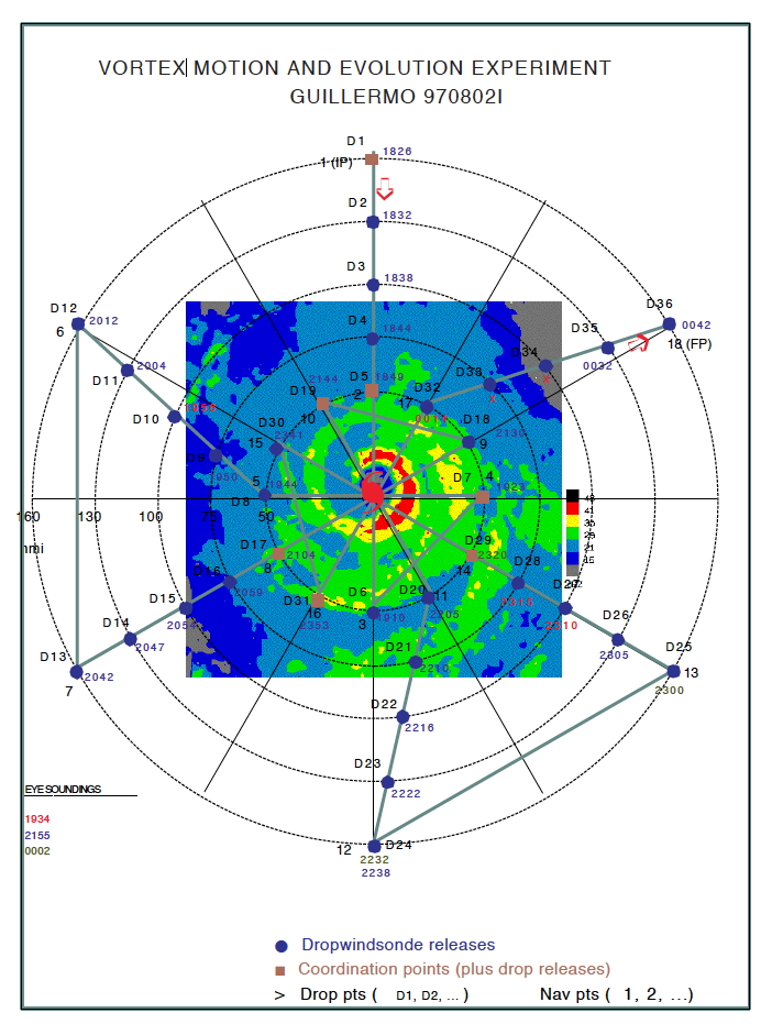
At 1500 UTC on 02 August, Hurricane Guillermo was located at 13.5°N, 106.5°W, moving towards 280 degrees at 11 kt, with maximum estimated sustained winds of 80 kt. The short term forecast was for continued westward motion. The VME mission called for both NOAA aircraft to fly coordinated, pre-determined flight patterns, collecting flight-level, Doppler radar, and GPS dropwindsonde data within 160 nm of the center of Guillermo. Planned takeoff times were 1700 UTC for N43RF, and 1630 UTC for N42RF, to allow both aircraft to reach their respective initial positions (IPs) near 1830 UTC. The VME pattern was to be rotated relative to the pattern in the HRD Field Program Plan, such that N43's IP would be north of the center, and N42's IP would be located east of the center. Three eye drops from N43RF were planned, on the second pass of each coordinated figure 4. Altitude was 17-18 kft, depending on icing conditions.
Most or all of the sondes had their RH sensors preheated to remove contaminants within 48 h of the mission. Several sondes had one of the two RH sensor heaters disabled to examine the effectiveness of the heaters. N43RF was to run its radar in FAST mode, while N42RF scanned in planes during the coordinated parts of the pattern.
Mission Summary :
| Take off | Landing
| Puerto Vallarta, Mexico | 17:01 UTC
| Puerto Vallarta, Mexico | 01:56 UTC
| | ||
The mission began with N43RF's takeoff from Puerto Vallarta at 1701 UTC. The IP (160 nm N of the center: 15 55.7°N 107 17.4°W) was reached at 1826 UTC. Drop/leg times in the pattern are summarized in the attached figure. Drop times in green, tan, and red indicate drops that were good, partial, and fail, respectively. The final position was reached at 0042 UTC, for a total pattern time of 6:16. N43RF recovered in Puerto Vallarta at 0156 UTC.
Mission Evaluation and problems :
Overall: Outstanding. This represents the best VME data set to date. All essential aspects of the mission were fully successful.
Aircraft coordination: Very good. All coordinated legs were run within about 1-2 min of each other.
Radar: Very good. There was only one signifcant failure. The radars went down from 2158-2202 UTC, during the second half of the second figure 4. N42RF switched to FAST mode at this point. Ample scatterers over nearly the entire pattern will enable the Doppler to fill in a gap in the dropsonde coverage (see below).
Dropsondes: Performance was very good, although a bit more altitude for the drops would have been nice. 30 of 39 sondes had good winds, 4 more were partial. There was an interior area on the east side of the storm where failures were concentrated. Most failures appear to be related to p-static. The legs at 300, 360, and 060 degrees were flown at 505 mb, the leg at 240 was flown at 485 mb, and the legs at 180 and 120 were flown at 465 mb. There was 1 successful eye drop.
Workstation: 38 TEMPDROP messages were transmitted. None were received at NCEP because they weren't looking for the UZPN13 KWBC header. The dropwindsonde scientists were able to keep up with the high data rate, but there was no time for any radar transmissions. A bug in the TEMPDROP decoder caused the synoptic map routine to fail towards the end of the flight.
Jimmy Franklin
Oct. 18, 1997