| Aircraft Commander |
| Co-pilot |
| Co-pilot |
| Navigator |
| Flight Engineer |
| Flight Director |
| System Engineer |
| Data Technician |
| Data Technician |
| LPS | John Gamache |
| Workstation | Paul Leighton |
| Dropsondes | Sam Houston |
| Radar | Mike Black |
| Radar | Neal Dorst |
Mission Plan :
To conduct an HRD-tasked VME mission into Guillermo. At the time of mission briefing, Hurricane Guillermo was estimated by Peter Black to have a central pressure of 960 mb and winds of approximately 110 knots. The official estimate for the time of our arrival (1830 UTC) was 85 knots. Strong convection was noted near the center of the storm, and it was thought that Guillermo might have a 6-nm radius eye. A strong band was was seen in the satellite imagery starting from the NW side of the eye and then extending NE of the storm center. Motion was estimated to be to be toward 285 azimuth at approximately 10 knots.
The decision was was to fly N42RF to the east side of the hurricane, and N43RF to the north side, and locate our IP's along those azimuths.
Mission Summary :
| Take off | Landing
| Puerto Vallarta, Mexico | 16:40 UTC
| Puerto Vallarta, Mexico | 02:04 UTC
| | ||
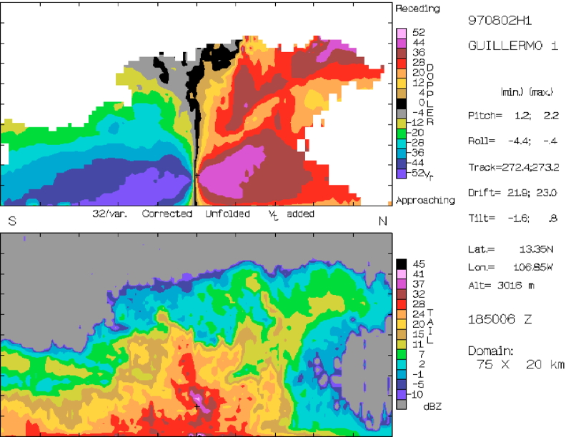
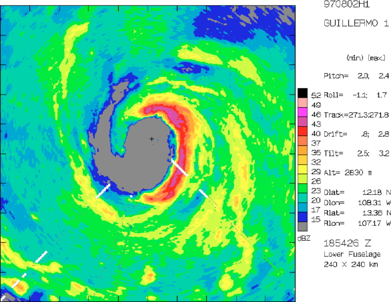
N42RF took off from Puerto Vallarta airport at 1640 UTC and flew SSE to the IP 130 nm east of the center. It descended to the mission flight level of 10,000 ft PA at 1816 UTC (13.9°N, 105.2°W) and reached the IP at 1826 UTC (13.3°N, 105.1°W), to begin the pattern that would result in 10 eye penetrations. The coordinated Doppler pattern began 45 nm from the estimated center at 1836 UTC (13.3°N, 105.9°W). Maximum flight level winds on the east side were 110 knots. The eye was approximately 40 nm across and elliptical in shape, and since this was the first attempt at a fix, and "hunting" was not to be done at the expense of Doppler data, a good fix was not found. The aircraft continued westward to point 3 in the pattern, 45 nm to the east of the center. Maximum winds on the west side were 95 knots. Echo tops were highest on the eastern portion of this leg and appear to reach to 16 km. At 1907 N42RF turned SE to begin the downwind leg of the first "figure 4," reaching a point 45 nm south of the center at 1922 UTC (12.6°N, 107.2°W). 42 then preceded northward, finding a 90-knot maximum flight level wind on the S side, and finding a center at 13.3°N, 107.25°W. Extrapolated MSLP was 956 mb. The first coordinated figure 4 was completed by flying a 45-nm leg to the north of the center, during which a 125 knot maximum flight level wind was found. Tail radar data were collected in planes perpendicular to the flight track (also known as normal scans) while in radial penetrations, and in conical scans oriented 22-23 degrees fore and aft of the plane perpendicular to the aircraft fuselage (Fore/aft scanning or FAST) during downwind legs.
The next two passes were not coordinated with N43RF, since it was farther from storm center executing its dropsonde pattern. The Tail radar was operated continuosly in FAST mode during this time, to permit a Doppler analysis to be performed for each pass through storm center, and thus maintaining a fairly consistent spacing between analyses. N42 executed a second figure 4 during this time (from 1943 UTC--14.1°N, 107.2°W to 2106 UTC-- 12.7°N 107.2°W),plus another 90 deg downwind leg after the figure 4, ending up at a heading 150 deg azimuth and 45 nm from storm center. During this time 2 further centers were found. The first was at 2001 UTC (13.3°N, 107.4°W, and 954 mb extrapolated MSLP), and the second was at 2042 UTC (13.3°N, 107.5°W, and 955 mb). Some of the best sunlight was seen during these passes. Maximum wind wind speeds were 108 knots on the NE side, 95 knots on the NW side, and 105 knots on the SE side.
|
|
|
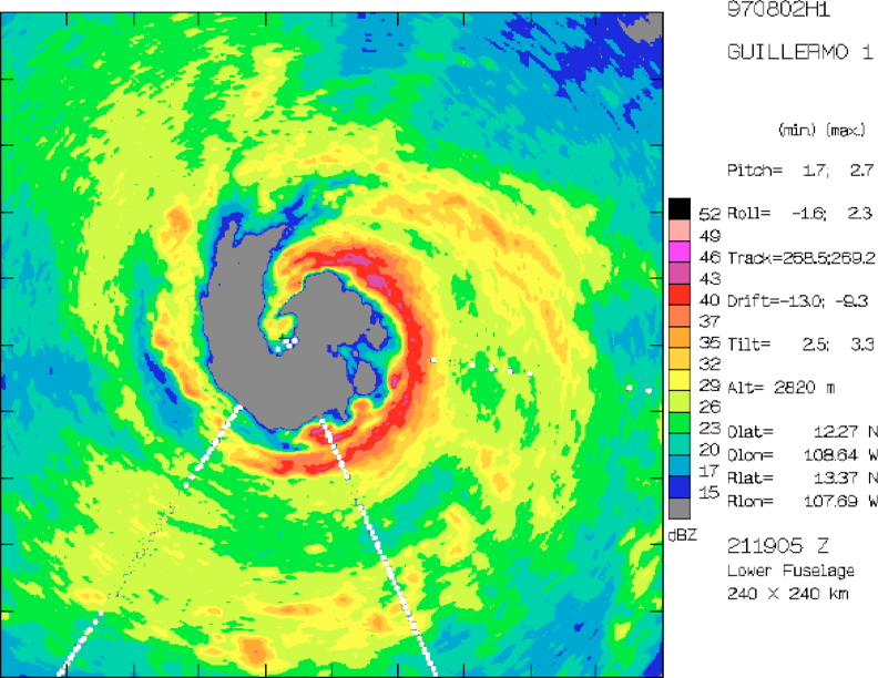
The next figure 4 coordinated with N43RF was oriented 60 degrees clockwise from the first one. The first radial leg was flown along a nominal track of 330 and the second along a nominal track of 60, with a downwind leg between the two radial legs. During these penetrations it appeared that the eye was being pinched off and thus was shrinking. The center estimate at 2154 UTC was 13.4°N, 107.6°W, with an extrapolated MSLP of 949 mb (an N43RF eye dropsonde estimate MSLP at 953 mb, and had winds less than 5 m/s all the way to the surface). Peak winds at RMW were 100 knots on the NW and SW sides, and 115 knots on the NE side. N43RF EXPERIENCED SOME DOWN TIME DURING THIS FIGURE 4, AND THUS PORTIONS OF THE N42RF RADIAL FLIGHT LEGS WERE FLOWN IN FAST, TO IMPROVE THE SINGLE-PASS RESOLUTIONS OF THE WIND FIELD.
The second "uncoordinated" figure 4 was then flown by N42RF as N43RF returned to the region beyond 50 nm from storm center. Two radial penetrations along nominal tracks of 210 and 300 azimuth were flown, and two estimates of storm center were made. The first was at 2225 UTC (13.3°N, 107.7°W, MSLP 948 mb), and the second was at 2257 (13.4°N, 107.8°W, 947 mb MSLP). During the penetration along track 210 a maximum wind was found in a rainband of 110 mb, and then a second maximum was found in the eyewall of 125 knots. Both of these were on the NE side of the center. Peak winds on the SE side were 105 knots, on the NW side were 98 knots, and on the SW side were 92 knots.
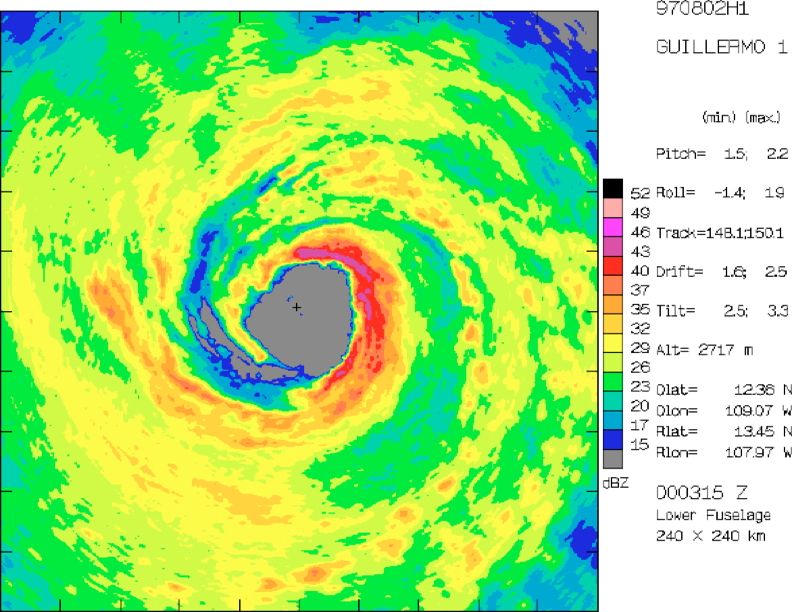
The third and final coordinated figure 4 was flown 60 degrees clockwise from the second one, with radial penetrations along tracks of 30 and 120 degrees. Two centers were estimated at 2332 UTC (13.4°N, 107.8°W, MSLP 946 mb), and at 0003 UTC (13.4°N, 108.0°W, MSLP 944 mb). Maximum winds on the NE, NW, and SE sides were 122 knots, 112 knots, and 105 knots, respectively. N42RF landed at Puerto Vallarta airport at 0204 UTC.
The day's motion computed from our center estimates was 285 degrees at 9 knots. Deepening may have been as much as 2 mb/h.
Mission Evaluation:
The mission was truly a great success, achieving for the first time, good coverage of the eyewall region and the region immediately beyond it with Doppler data, as well as by far the most complete coverage of the region from 50 nm to 160 nm with dropsonde data. Although there were a few failures of 43's GPS sonde drops, these regions should be covered well by airborne Doppler data. The observations described here occurred in a storm that appeared to be intensifying rapidly, while undergoing rapid changes in eyewall shape and orientation. The data set promises to help our understanding of the interaction of the eyewall region with its immediate environment, and may help us understand storm motion and intensity change better.
| Fix | Time | Location | MSLP | Comments | |
| (UTC) | (Lat °N) | (Lon °W) | (mb) | ||
| 1 | ~1854 | N/A | N/A | N/A | coordinated with N43RF |
| 2 | 1933 | 13.3 | 107.25 | 956 | coordinated with N43RF |
| 3 | 2001 | 13.3 | 107.40 | 954 | |
| 4 | 2042 | 13.3 | 107.50 | 955 | |
| 5 | 2119 | 13.3 | 107.55 | 952 | |
| 6 | 2154 | 13.4 | 107.60 | 949 | coordinated with N43RF |
| 7 | 2225 | 13.3 | 107.70 | 948 | coordinated with N43RF |
| 8 | 2257 | 13.4 | 107.80 | 947 | |
| 9 | 2332 | 13.4 | 107.80 | 946 | coordinated with N43RF |
| 10 | 0003 | 13.4 | 108.00 | 944 | coordinated with N43RF |
Problems :
N43RF EXPERIENCED SOME DOWN TIME DURING ONE FIGURE 4, AND THUS PORTIONS OF THE N42RF RADIAL FLIGHT LEGS WERE FLOWN IN FAST, TO IMPROVE THE SINGLE-PASS RESOLUTIONS OF THE WIND FIELD.
John Gamache
Oct. 18, 1997