Mission Summary
20040904I1 Aircraft 43RF
Hurricane Frances Tasked SFMR Mission
Scientific Crew (43RF)
| Lead Scientists | Peter Dodge
Mike Black |
| SAR Scientist | Ed Walsh |
| Journalists |
Joe Duncan
Rob Stafford |
Flight Crew (43RF)
| Flight Director | Tom Shepherd
|
| Pilots | LCDR Randy Tebeest
LCDR Barry Choy
LCDR Tom Strong
|
| Navigators | Ensign Tim Gallagher
LT Peter Siegel
LCDR John Adler
|
| Flight Engineers | Joe Klippel
Randy Mitchell
|
| Systems Engineer | Jeff Smith
|
| Systems Analyst | Terry Lynch
|
| Electronics Technician | Ray Tong
|
Mission Plan :
AOC was tasked by NHC to collect Stepped Frequency Microwave
Radiometer (SFMR) data in land-falling Hurricane Frances on 4 September
2004, the final flight in a six-day series of SFMR and CBLAST missions.
Teams from Texas Tech (TTU), University of Oklahoma (OU), the Florida
Coastal Monitoring Program (FCMP) and the Center for Severe Weather
Research (CSWR) had deployed portable wind towers and Doppler radars
from Fort Pierce to Melbourne to capture data as the storm came ashore.
HRD assisted the AOC flight director and navigator in designing a
flight pattern that would meet the operational requirements but also
allow high-density observations near the deployed ground teams.
Takeoff from New Orleans, LA was to be at Noon and recover at
New Orleans, LA at 9:00 PM EDT.
Mission Summary :
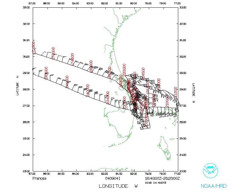
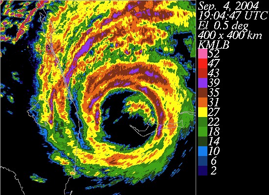 NOAA 43 departed New Orleans Naval Air Station at 1637 UTC. We
reached the IP, where buoy 41009 used to be, at 1837. After hitting
the eye at 1901 we headed N and then back to the coast. We then headed
south along the coast, deploying sondes near the ground stations. At
1943 we descended to 5000', to get better coverage for the SRA. At
1955 we were basically flying down the eyewall which was slowly
approaching the coast.
NOAA 43 departed New Orleans Naval Air Station at 1637 UTC. We
reached the IP, where buoy 41009 used to be, at 1837. After hitting
the eye at 1901 we headed N and then back to the coast. We then headed
south along the coast, deploying sondes near the ground stations. At
1943 we descended to 5000', to get better coverage for the SRA. At
1955 we were basically flying down the eyewall which was slowly
approaching the coast.
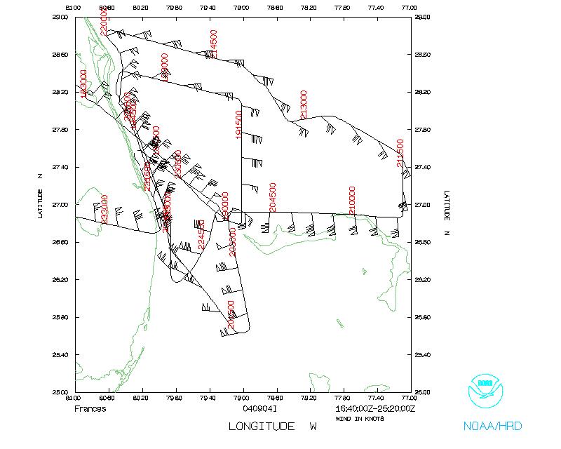
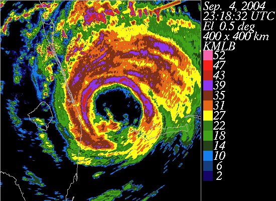 At 2005 we turned to head SE from the Lake Worth C-MAN station
(LKWF1). Ed Walsh started raving about how well the SRA and SFMR rain
rates agreed. The southernmost point in our pattern was reached at
2014 and then we headed back N. At 2023 Grand Bahama was in the east
eyewall as we passed overhead. We turned N of the island and flew ~150
km east, to define the windfield on the east side of Frances. To
complete the mapping of the NE quadrant 43 turned N at 77 deg W, and
then flew a long leg WNW back to the coast. At 2200 we turned N of Cape
Canaveral and then flew a long coastal run to ~50 km S of LKWF1.
At 2005 we turned to head SE from the Lake Worth C-MAN station
(LKWF1). Ed Walsh started raving about how well the SRA and SFMR rain
rates agreed. The southernmost point in our pattern was reached at
2014 and then we headed back N. At 2023 Grand Bahama was in the east
eyewall as we passed overhead. We turned N of the island and flew ~150
km east, to define the windfield on the east side of Frances. To
complete the mapping of the NE quadrant 43 turned N at 77 deg W, and
then flew a long leg WNW back to the coast. At 2200 we turned N of Cape
Canaveral and then flew a long coastal run to ~50 km S of LKWF1.
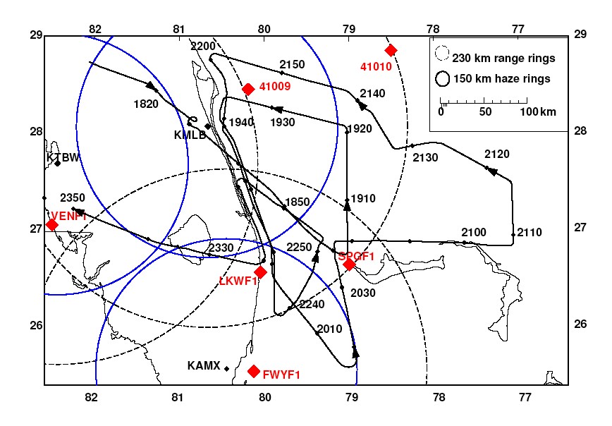 We finished off with a final pass through the center and one
more abbreviated run S to LKWF1. At 2319 43 turned to the NW, climbed
and headed back to Louisiana, landing at 01194 IC at Lakefront Airport
in New Orleans.
We finished off with a final pass through the center and one
more abbreviated run S to LKWF1. At 2319 43 turned to the NW, climbed
and headed back to Louisiana, landing at 01194 IC at Lakefront Airport
in New Orleans.
Acknowledgments :
Prof. John Schroeder, Prof. Mike Biggerstaff, Dr. Josh Wurman,
and Dr. Forrest Masters kept us apprised of the latest mobile platform
positions which were crucial for our attempts to target their sites
with GPS drops. Tom Shepherd and the rest of the AOC flight crew were
helpful in modifying the flight track to help us achieve the research
goals while still maintaining the operational integrity of the mission.
We all were tired after flying six days straight and the professional
attitude of the AOC crew really shone through. The chefs at Mulates
have our compliments.
Mission Data :
One minute listing
Tables :
Table 1
Mobile Platforms
| Lat | Lon | Platform
|
| 27 08' 53.3" | 80 12' 53.9" | T0 FCMP Port Salerno
|
| 28 08' 41,6" | 80 35' 49.4" | T1 FCMP Indian Harbor Beach
|
| 27 41' 38.1" | 80 24' 29.5" | T2 FCMP Vero Beach
|
| 27 26' 50.3" | 80 19' 17.9" | T3 FCMP Fort Pierce
|
| 27 39' 01.0" | 80 25' 02.8" | WEMITE 1 Tower TTU Vero Beach Mun.. Airport
|
| 28 03' 15.6" | 80 33' 14.8" | WEMITE 2 Tower TTU Melbourne Beach
|
| 27 48' 46.4" | 80 29' 53.9" | SBCOM Tower 1 Sebastian Airport
|
| 27 17' 27.4" | 80 13' 19.4" | SBCOM Tower 2 St Lucie Intl. Airport
|
| 28 20' 27.6" | 80 41' 15.5" | SR1 TTU/OU/NSSL Titusville Intl. Airport
|
| 28 30' 41.3" | 80 47' 59.3" | SR2, Tower TTU/OU/NSSL Space Coast Reg. Airport
|
| 27 26' 25.4" | 80 19' 14.9" | DOWs CSWR near Hutchinson Island
|
Note Some of these positions were converted from decimal lat
and lon.
Table 2
Center fixes
Time
UTC
| Lat
d m
| Lon
d m
| MSLP
mb
| Source
|
| 1901 | 26 48 | 79 07 | 958 | NOAA 43
|
| 2036 | 26 54 | 79 19 | 960 | NOAA 43
|
| 2042 | 26 56 | 79 11 | 959 | Air Force
|
| 2225 | 26 54 | 79 18 | 951
(wrong) | Air Force
|
| 2252 | 26 55 | 79 20 | 960 | NOAA 43
|
Table 3
GPS Sonde Drops
| #
| Serial #
| Launch Time
UTC
| Lat
| Lon
| Splash Time
UTC
| Comments
|
| 1 | 004255305 | 1840 | 27.65 | 80.30 | 1843 | WL150 02057 085 DLM 03579 995748 MBL 02567 RAINBAND
|
| 2 | 033048008 | 1851 | 27.13 | 79.71 | 1855 | WL150 01088 097 DLM 03588 976749 MBL 01594 LST 022 EYEWALL 315
|
| 3 | 032418089 | 1909 | 27.33 | 79.10 | 1912 | WL150 06589 085 DLM 09588 971753 MBL 07595 EYEWALL 000
|
| 4 | 004255170 | 1909 | 27.35 | 79.12 | 1912 | WL150 06585 085 DLM 08602 973821 MBL 07092 EYEWALL 000
|
| 5 | 004255300 | 1921 | 28.14 | 79.19 | 1924 | WL150 07571 085 DLM 09077 994752 MBL 07576
|
| 6 | 033415318 | 1931 | 28.31 | 80.10 | 1934 | WL150 05055 095 DLM 05570 998753 MBL 05061 LST 020
|
| 7 | 010715016 | 1940 | 28.02 | 80.47 | 1944 | WL150 03557 145 DLM 04574 992753 MBL 04062 LST 070
|
| 8 | 033415071 | 1946 | 27.65 | 80.27 | 1949 | WL150 02062 108 DLM 03576 991811 MBL 02070 LST 033
|
| 9 | 010715022 | 1952 | 27.28 | 80.10 | 1954 | WL150 01065 085 DLM 02575 987843 MBL 01572
|
| 10 | 004255169 | 2001 | 26.57 | 79.87 | 2002 | WL150 32071 144 DLM 33077 974844 MBL 32075 LST 069
|
| 11 | 004255169 | 2001 | 26.57 | 79.87 | 2002 | WL150 32071 144 DLM 33077 974844 MBL 32075 LST 069
|
| 12 | 033415073 | 2018 | 25.77 | 78.90 | 2020 | DLM 24074 988842
|
| 13 | 033518004 | 2027 | 26.30 | 79.00 | 2028 | WL150 22588 092 DLM 24091 974836 MBL 23092 LST 017 EYEWALL 180
|
| 14 | 010715023 | 2027 | 26.32 | 79.00 | 2029 | WL150 22588 085 DLM 23095 975911 MBL 22594 DLM 23095 975911 EYEWALL 180
|
| 15 | 004255171 | 2044 | 26.98 | 78.64 | 2046 | WL150 14605 085 DLM 16105 969838 MBL 14606
|
| 16 | 004255171 | 2044 | 26.98 | 78.64 | 2046 | WL150 14605 085 DLM 16105 969838 MBL 14606 EYEWALL 090
|
| 17 | 004255302 | 2045 | 26.98 | 78.60 | 2047 | WL150 14100 085 DLM 16104 973833 MBL 14601 EYEWALL 180
|
| 18 | 032335190 | 2054 | 26.96 | 78.06 | 2056 | WL150 14072 088 DLM 15584 989834 MBL 14576 LST 013 RAINBAND
|
| 19 | 032335191 | 2110 | 27.03 | 77.12 | 2112 | WL150 14551 085 DLM 16067 000842 MBL 15062
|
| 20 | 032335195 | 2123 | 27.87 | 77.76 | 2125 | WL150 11056 085 DLM 13073 998844 MBL 12067
|
| 21 | 032335188 | 2133 | 27.95 | 78.56 | 2135 | WL150 09563 085 DLM 10574 994844 MBL 10070
|
| 22 | 032335189 | 2148 | 28.62 | 79.67 | 2150 | WL150 05556 196 DLM 06061 987931 MBL 06058 LST 121
|
| 23 | 032335174 | 2205 | 28.53 | 80.49 | 2207 | WL150 06054 085 DLM 06563 001844 MBL 06060
|
| 24 | 010715097 | 2211 | 28.04 | 80.49 | 2213 | DLM 05064 983844 MBL 03564 LST 134
|
| 25 | 010715018 | 2244 | 26.45 | 79.47 | 2245 | WL150 26584 085 DLM 26084 972957 EYEWALL 225
|
| 26 | 010715024 | 2259 | 27.22 | 79.76 | 2301 | WL150 02078 085 DLM 02080 970945 EYEWALL 315
|
| 27 | 004255296 | 2300 | 27.23 | 79.79 | 2301 | WL150 02102 158 DLM 03107 963847 MBL 02102 LST 083 EYEWALL 315
|
Note 32 sondes were dropped; this table lists the 27 sondes
that were transmitted to NHC.
WL150: Wind in lowest 150 m
DLM: Deep Layer Mean wind
MBL: Mean Boundary Layer Wind
LST: Height of lowest wind.
Page last updated February 1, 2005
Return to Mission page.