| Lead Scientist/Radar | F. Marks |
| AXBT | P. Reasor (CSU) |
| Dropsonde | C. Landsea |
| Workstation | M. Black |
| Air-sea interaction Scientist | E. Walsh (NASA/GSFC) |
| Observers | J. Palca, S. Bear (NPR) |
Mission Briefing:
On Tuesday 14 September N43RF was tasked to do a two-plane
synoptic surveillance mission with N49RF into Hurricane Floyd
as it passed Nassau, Bahamas with a takeoff from MacDill AFB at
1730 UTC and landing at Tampa International Airport around 0230 UTC.
The plan called for figure-4 at 14,000 ft with 50 nm legs with
GPS drops on the ends of the legs and in the eyewall on the
four cardinal directions. One drop was also planned in the eye
on the first pass through the center with a backup on the second
and last pass through the center. Following the figure-4
pattern N43RF would climb to as high as possible and execute
the surveillance pattern covering the area surrounding the S,
E, and N sides of the storm while N49RF would sample the far
environment N and E of the storm at 41,000 ft. Our final leg
would pass just N of the storm over the buoys E of Cape
Canaveral, FL and the WSR-88D at Melbourne, FL (KMLB)
(Table 1). We planned to
drop a string of AXBTs along that final E-W
track to sample the seasurface temperature (SST) and mixed
layer depth (MLD) in front of the storm in a region where
Dennis had just passed. We also planned some GPS-sonde drops
near any buoys and C-MAN sites in
Table 1 if possible.
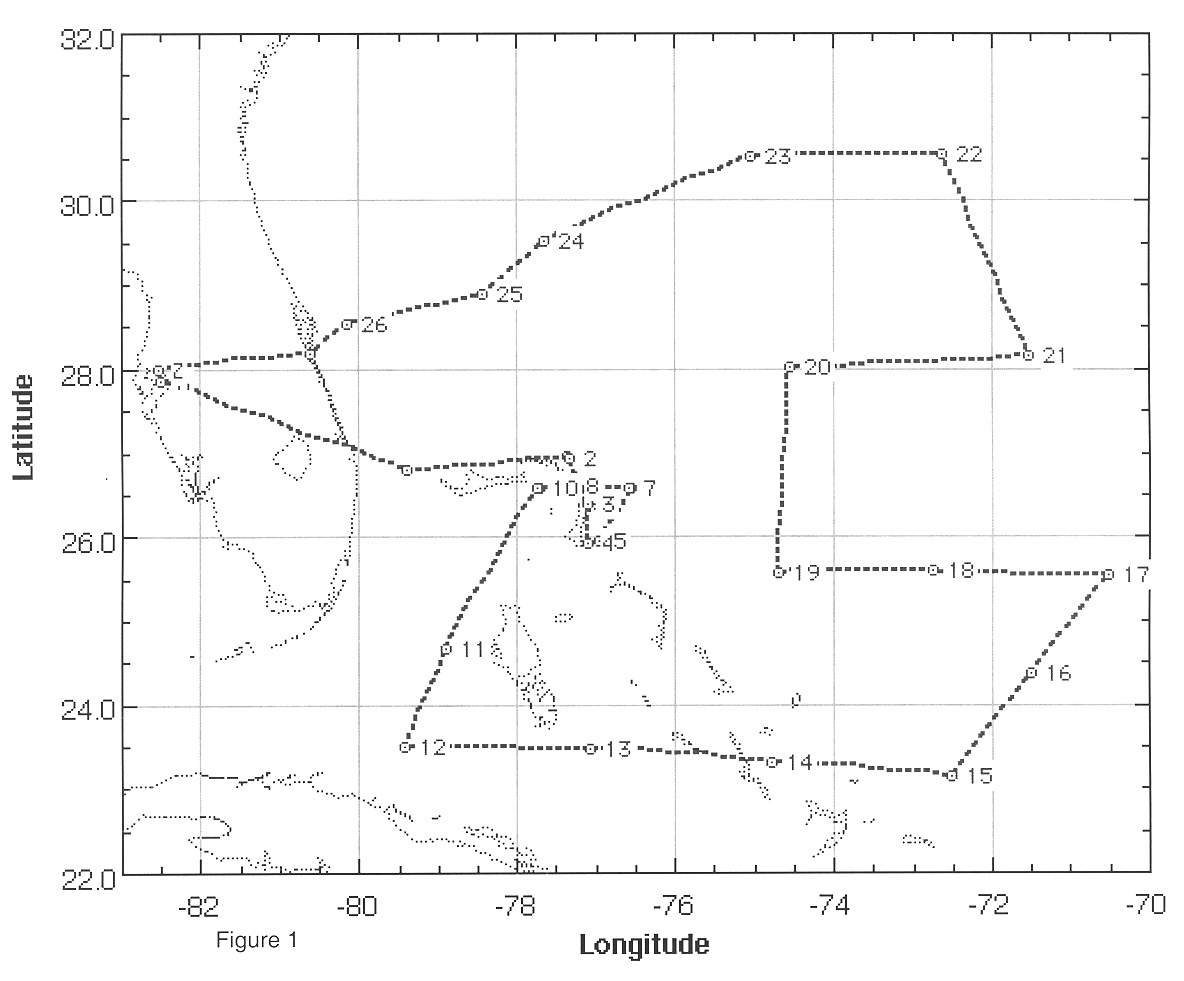
Mission Synopsis N43RF took off from MacDill AFB at 1815 UTC and headed toward an IP 50 nm N of the storm. As we approached the storm it became apparent that it was farther E and N than the forecast track suggesting the storm had started its anticipated northward turn sparing southern Florida. At about the same time we received the AFRES latest fix confirming our radar presentation (Table 2). We adjusted our IP to reflect the change in position at 1858 UTC (Fig.l).
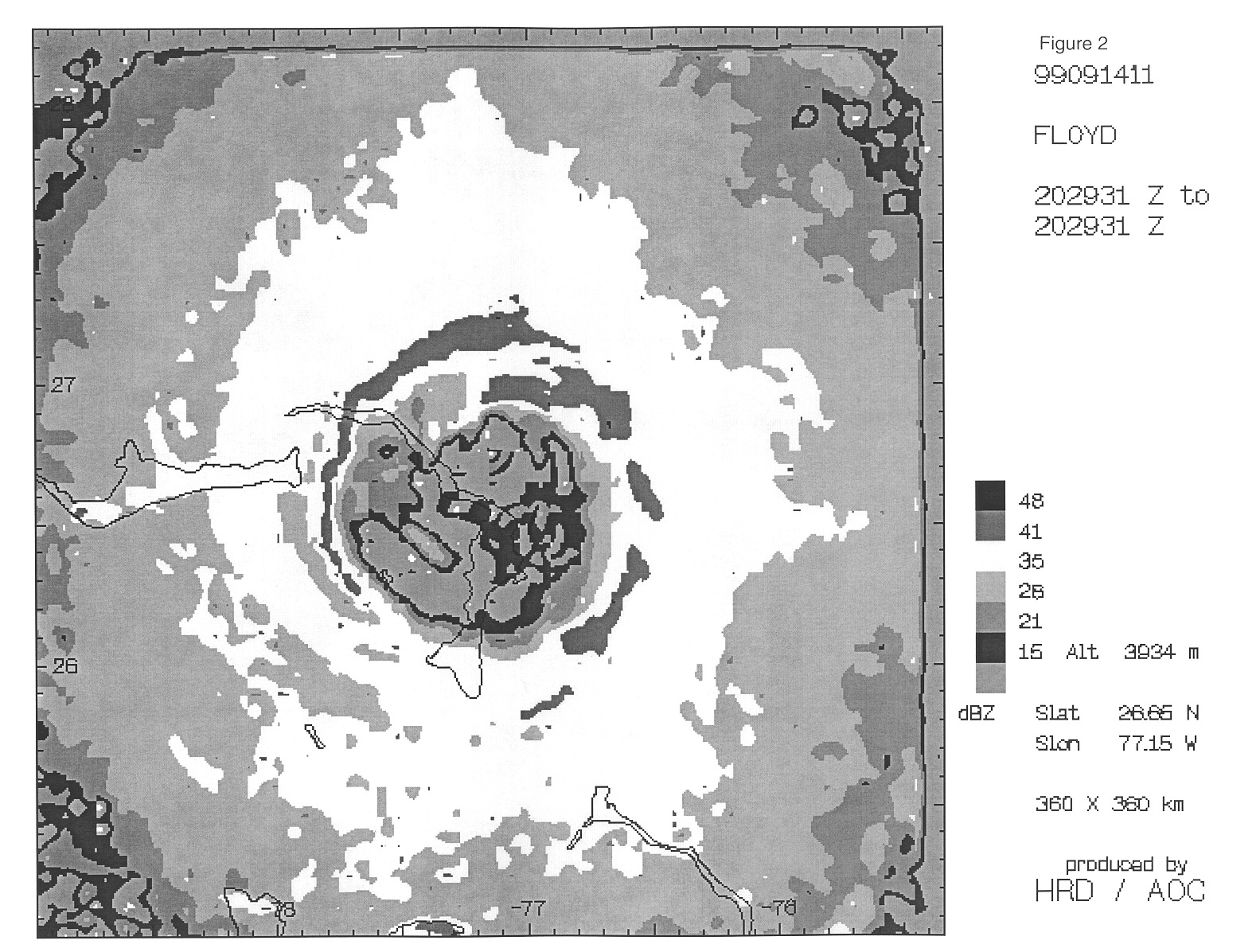
The LF and TA radars were acting up (the TA wouldn't hold frequency) and the engineers swapped the TA transmitter. The LF showed that the storm had changed considerably from the (Fig. 2), with the near completion of an eyewall replacement cycle. There was only a large outer eyewall (60 nm diameter) encompassing a small inner hub cloud (the remains of the inner eyewall). At 1910 UTC the radar system crashed and the engineers started to diagnose the problem, starting a process that became commonplace on this mission.
We reached our IP (50 nm N of the storm) at 1931 UTC, dropped a GPS sonde and AXBT and tracked S to the center at 14,000 ft. The sonde worked (no winds below 800 mb) and the AXBT gave a SST of 27.5°C (Table 3). With such a large eyewall we attempted 2 eyewall drops on the N side 3 min later, one of which gave no winds. We hit the center at 1943 UTC right over Abaco Island, Bahamas and dropped a sonde that landed on the island with a 932 mb central pressure. We received no winds from this sonde either. We proceeded to track S down the island to a point 50 nm S of the center dropping one more eyewall sondes which had no winds. At 1955 UTC we reached the point 50 nm S of the center, dropped a sonde (which had winds), and turned NE. We produced one radar composite, but no EVTD as the TA radar was still giving problems.
At 2011 UTC we reached the point 50 nm E of the center, dropped a sonde (no winds) and turned W to the center. We attempted a drop in the E eyewall which also had no winds. Dale Carpenter suspected the either a bad batch of sondes or the ribbon used to pull out the launch pin was too tight. He tried loosening the ribbon. We passed through the center at 2029 UTC, two minutes after the AFRES fixed the center, and dropped a sonde which still had no winds. Passing through the eye the radar started working well and we started recording TA data in F/AST mode through the W eyewall. We also attempted dropsondes in the W eyowall and at the point 50 nm W of the center which both failed (one with no winds, one with no launch detect). We reached the end of the figure-4 at 2040 UTC and turned SW to our first surveillance drop. At this time Dale started using a new box of sondes and we never had a problem with the sondes the rest of the flight. Mike Black transmitted two more LF composites and then settled down for some dropsonde processing.
The first surveillance drop was just NW of Andros Island. We then proceeded to a point just off the NE coast of Cuba (23.5°N, 79.5°W) where we turned to the E to a point .300 nm SE of the center. We then zig-zagging N along the E side of the storm. We encountered an intense rainband with lightning ~200 nm E of the center at 2355 UTC. Unfortunately, the main data system failures started getting worse at this time, crashing from 2355-0009 UTC, causing us to have problems with drop 19 (Table 3). Chris Landsea manually input the flight level data from the 10 s listing to get the sonde out. Richard McNamara and Jorge Delgado swapped the CPUs on the main data system and we were up again for a while. We limped along with data system problems heading N along the NE side of the pattern. At 0103 and 0130UTC the data system crashed again and was revived within a few minutes, but Barry Damiano noted that the tape drive might not be recording data. We discussed the data recording problems and agreed to try to finish out the surveillance pattern transmitting the drops back to NHC even if the data system was not recording data provided the onboard data display was still working. We reached the far NE portion of our pattern at 0126 UTC and turned WSW to track toward Cape Canaveral N of the storm laying down a string of AXBTs along with our dropsondes.
As we tracked WSW N of the center it became apparent that the storm was farther N than we had expected and would pass only about 80 nm S of our track. We decided to alter our plan slightly to add an 8000 ft leg near the shore toward KMLB to acquiee some storm surge and wave spectra data, as well as provide some intercomparison with the KMLB WSR-88D radar. We planned the decent to correspond with a GPS sonde drop over buoy 41009 just E of Cape Canaveral (Table 1). Along this leg the data system crashed one more time at 0159 UTC and Richard couldn't bring it up and record the data as well. Ed Walsh said he had his own source of the necessary flight level data (as did the radar data system) so we proceeded with the planned low-level beach run. Unfortunately, the only record of the AXBTs was from the 5-s onboard listing. We completed our last surveillance drop at 0218 UTC and descended to 8000 ft by our combo drop near buoy 41010 at 0229 UTC. At 0236 UTC, in rainbands 80 nm NW of the center the TA was set to FAST and we started the 8000 ft run at the beach within Doppler range of KMLB. We crossed the beach at 0252 UTC passing directly over Patrick AFB. Ed Walsh was ecstatic with the surge and wave data. We turned W heading for Tampa recording radar data inland until we passed S of Orlando. We landed at Tampa International at 0319 UTC.
Accomplishments
This mission was a very draining experience with radar and main data system problems. Considering all of the data system problems the AOC and HRD crew did a fantastic job to get all of the surveillance drops out for NHC and to get some really good landfall research data (wave, surge, and Doppler radar data) along the coast of FL at the end of the mission. The AOC crew, particularly Barry Damiano, Richard McNamara, Jorge Delgado, and Dale Carpenter, deserve special credit for accomplishing the tasked operation surveillance mission despite all of the equipment problems. The mission was successfully completed thanks to their hard work and dedication.
Penetrations: 2
GPS sondes: 26, 7 failed
AXBTs: 8, 3 failed
Problems:
Although the primary operational surveillance mission was accomplished, there were several major glitches during this mission that compromise the research quality of the data.
Frank Marks
HRD/NOAA