| Chief Scientist | Michael Black |
| GPS Dropsonde | P. Dodge/Bob Black |
| Workstation/Radar | Peter Dodge |
| Step Frequency (SFMR) | Jim Carswell/Eric Uhlhorn |
| Pilots | Taggert, Tennesen, O'Mara |
| Flight Director | Stan Czyzyk |
| Navigators | Newman |
| Systems Engineer | Jim Roles/Sean McMillan |
| AVAPS Operator | Jorge Gonzales |
Mission Briefing:
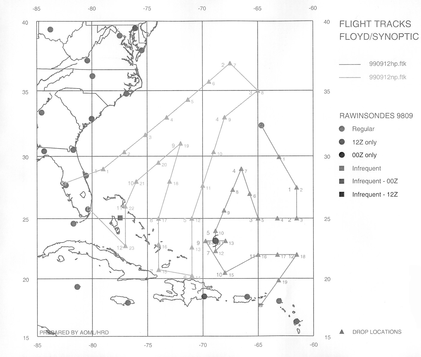
An NHC-tasked, two-aircraft synoptic surveillance mission (N42RF and N49RF) was planned for 12 September 1999. N49RF would depart from MacDill AFB at 1730 UTC and fly to the northeast covering the oceanic areas of north and west of Hurricane Floyd, and return to Miami. Meanwhile for this mission, N42RF, after recovering the night before in Bermuda, would also takeoff at 1730 UTC cover the area northeast of Floyd, fly a figure four pattern through Floyd's center, and land in St. Croix, USVI. N42RF was to release 19 dropsondes along the track with additional eye and eyewall drops to be decided upon in flight. During the figure 4, N42RF would descend to 14,000 ft. altitude to avoid icing problems and then climb back to maximum altitude for the rest of the mission. Floyd was forecast to be an intensifying Category 3 hurricane located near 23° N 68° W or about 400 km NNE of the eastern portions of Hispañola. Hurricane Floyd was continuing on a westward track toward the Bahamas and Florida. Figure 1 shows the planned flight tracks of both N43RF and N49RF.
Mission Synopsis:
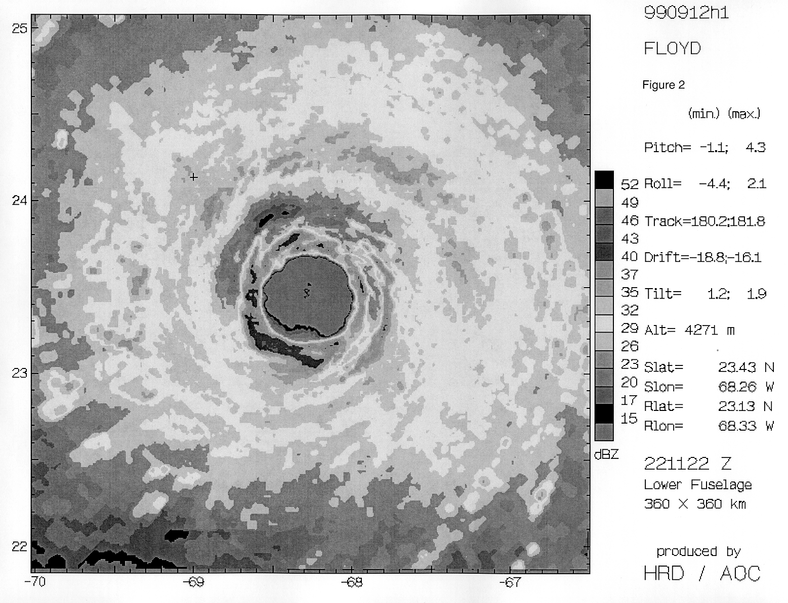
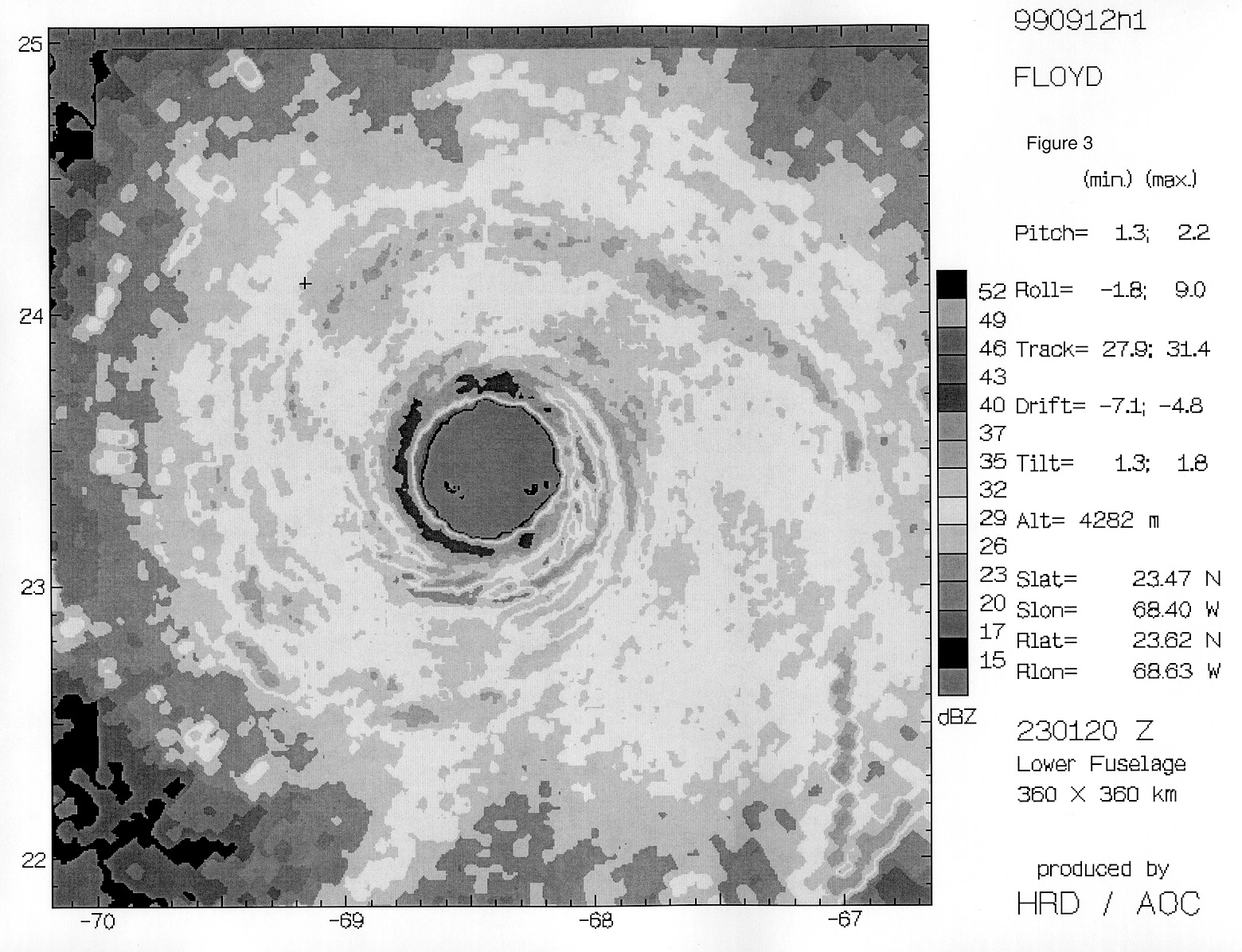
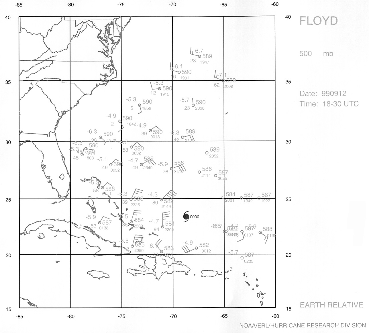
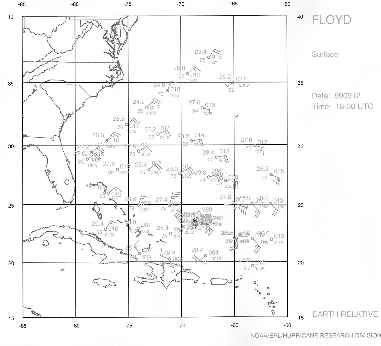
Takeoff from Bermuda was at 1729 UTC and we started releasing dropsondes at 1854 UTC. Shortly after Floyd was visible on radar, it was obvious that this was an intense, mature hurricane. The eye was clear of scatterers and the eyewall appeared as a nearly continuos ring of high reflectivity (Figure 2). There was a moat of low reflectivity forming outside of the eyewall and a suggestion of an outer eyewall at ~100 km radius, At 2133 UTC, we descended to 14,000 ft. to begin the inner core figure 4 pattern, arriving from the north, N42RF reached the outer eyewall at 2154 UTC and released a dropsonde. Next, we entered the convective northern eyewall and released 3 GPS sondes in rapid succession (within 10 seconds) near 2203 UTC. Although none of these three sondes reported winds to the surface, the first one had winds of 174 kt at ~500 m height. The WP-3D reached the eye of Floyd at 2208 UTC and dropped a sonde to mark the center. Unfortunately, this sonde failed below about 850 mb. The eye was spectacular, with good visibility of the eyewall, sea surface, and the sky above. The center of Floyd was located 23° 21' N, 68° 20' W, very close to the forecast position by NHC. Flightlevel winds of ~135 kts were observed in the northern eyewall. We exited the eye to the south, where maximum flight level wind were ~110 kts, and dropped two sondes in the outer eyewall, both of which failed to report winds. After, a short downwind leg to the northeast, the WP-3D headed back to Floyd's eye approaching from the east and recording peak flight-level winds of ~130 kts. We dropped one sonde in the east eyewall and one in the eye at 2300 UTC. this sonde reported a surface pressure of 936 mb. The LF radar imagery was still very impressive and Floyd now had several small rainbands spiraling just outside of the eyewall ( Figure 3). While in the eye, we tried a maneuver that was performed successfully in Hurricane Bret earlier this year. The pilots would fly the aircraft toward the eyewall, turning the plane upwind just before entering the high wind and reflectivity region of the eyewall. We deployed 3 dropsondes in rapid succession along the inner edge of the NE eyewall. The purpose was to try and examine the wind and convective structure in features below the plane in the outwardly-tilting eyewall. Unfortunately, all three of these sondes had complete or partial wind failures. After orbiting once in the eye, we returned to a westward track through the west eyewall, where we recorded flight-level winds of ~115 kts and releasing 2 GPS sondes. Only one of these 2 sondes reported good winds. We deployed additional sondes in rainbands on the west side of Floyd and climbed back up to ~20,000 ft to resume the rest of the synoptic mission. After releasing sondes to the east and southeast of Hurricane Floyd, we landed at St. Croix at 0251 UTC. Examples of the observations recorded from the GPS sondes from N42RF and the N49RF at 500 mb, 850 mb, and the surface are in Figures 4, 5, and 6, receptively.
Evaluation:
The two aircraft, tasked (NHC) synoptic-surveillance mission provided important information from both the periphery and inner core regions of an intense Hurricane Floyd. The flights were conducted a couple of days before a potential landfall in the SE United States, including Florida. The radar and GPS sonde data should be useful in continuing studies of the hurricane eyewall and rainbands. The SFMR data looked to be both reliable and matched up fairly well with the few GPS sonde surface winds.
Problems:
N42RF released 33 dropsondes, transmitted 23, and had 8 full or partial failures, a much higher - than-normal failure rate. The inability of the sondes to report surface or near-surface winds was especially frustrating. The radar system was frozen for a few minutes, but the AOC crew was able to quickly recover it.
Michael Black