Mission Summary
20080818N1 Aircraft 49RF
Fay flight 2008
Aircraft Crew (49RF)
| Aircraft Commander | Michelle Finn
|
| Flight Director | Marty Mayeaux |
| Dropsonde | Mike Black |
| AVAPS | Al Goldstien
Dale Carpenter |

Figure 1. Planned track of N49. Small circles along the flight track
are dropsonde locations.
Mission Plan :
This mission was tasked by NHC as the 3rd in a series of synoptic surveillance
flights around TS Fay. Prior to the flight, Fay was approaching west-central
Cuba from the south and heading north over Cuba to a forecast landfall over
west Florida in a couple of days. Fay had maximum winds of 50 kt but was
forecast to strengthen over the Florida straits the following day. The planned
track for the mission, which was hand drawn by NHC (Fig. 1) would sample the
high pressure system to the east of Florida, head south and fly between Haiti
and Cuba, head to the west south of Fay before heading to the Gulf of Mexico
to sample the eastern portion of an approaching trough in the northern Gulf.
The plan was to release 27 dropsondes along the proposed track. During the
preflight briefing we decided to extend the most NW portion of our flight to
the west by 2 degrees and add 2 more dropsondes there. CARCAH and NHC were
consulted and agreed that this would be deirable.
Synoptic Surveillance
MISSION PLAN
Fay
August 16, 2008 11:30 AM
Aircraft: N49RF
Altitude: FL410-450
Proposed takeoff: 18/0530Z
|
DROP
#
| LAT
(d m)
| LON
(d m)
|
| 1 | 31 00 | 78 00
|
| 2 | 31 00 | 75 30
|
| 3 | 31 00 | 73 00
|
| 4 | 29 30 | 73 00
|
| 5 | 28 00 | 73 00
|
| 6 | 28 00 | 75 00
|
| 7 | 28 00 | 77 00
|
| 8 | 26 15 | 77 00
|
| 9 | 24 30 | 77 00
|
| 10 | 23 15 | 75 30
|
| 11 | 22 00 | 74 00
|
| 12 | 20 30 | 73 30
|
| 13 | 19 00 | 74 00
|
| 14 | 19 00 | 76 30
|
| 15 | 19 00 | 79 00
|
| 16 | 19 30 | 81 30
|
| 17 | 20 00 | 84 00
|
| 18 | 21 30 | 85 30
|
| 19 | 23 00 | 87 00
|
| 20 | 23 45 | 85 30
|
| 21 | 24 30 | 84 00
|
| 22 | 26 00 | 84 00
|
| 23 | 26 00 | 86 30
|
| 24 | 26 00 | 89 00
|
| 25 | 28 30 | 89 00
|
| 26 | 28 30 | 87 00
|
| 27 | 28 30 | 85 00
|
| Take off
| Landing
| MacDill AFB, FL | 05:15 UTC
| MacDill AFB, FL | 13:45 UTC
| |
Mission Summary :
N49 took off from MacDill at 0515 UTC and headed east over Florida to the
western Atlantic to begin our mission. We dropped a total of 32 dropsondes,
3 of which were backups to sondes that failed. Drop # 2 was a fast wall and
only the data from the backup was transmitted. Drop # 3 did not report winds
and, again, the data from a backup was transmitted. From then on, all of the
sondes were good until drop # 17 that had only a few wind measurements. The
backup was again used for data transmission.
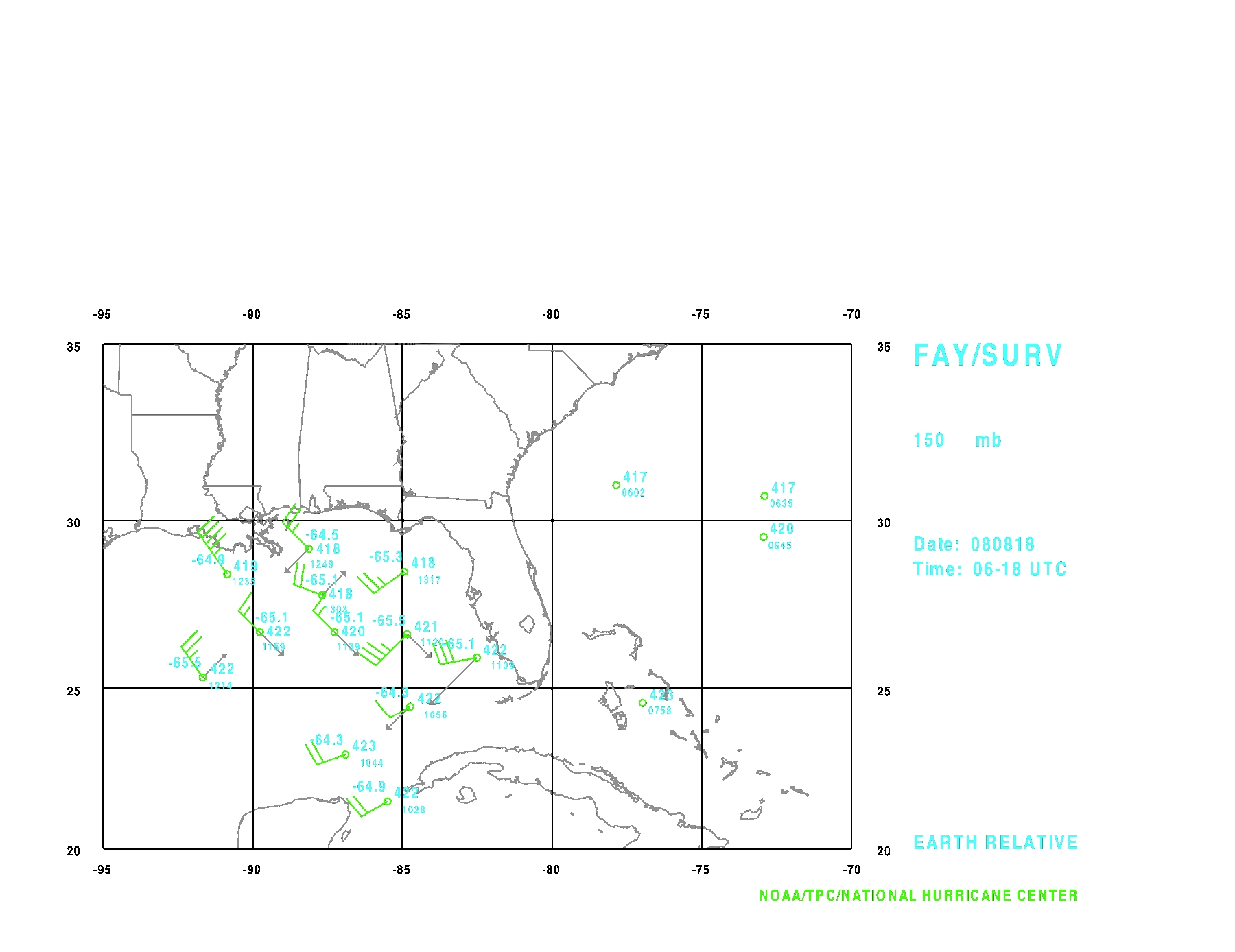
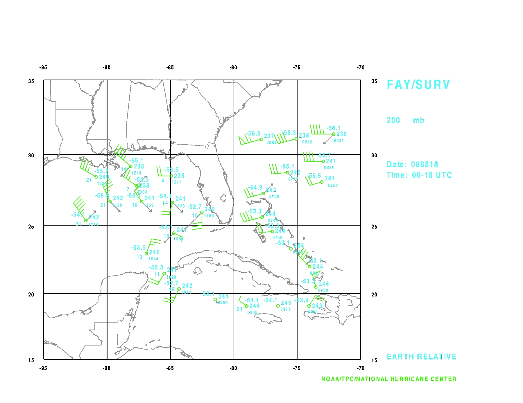
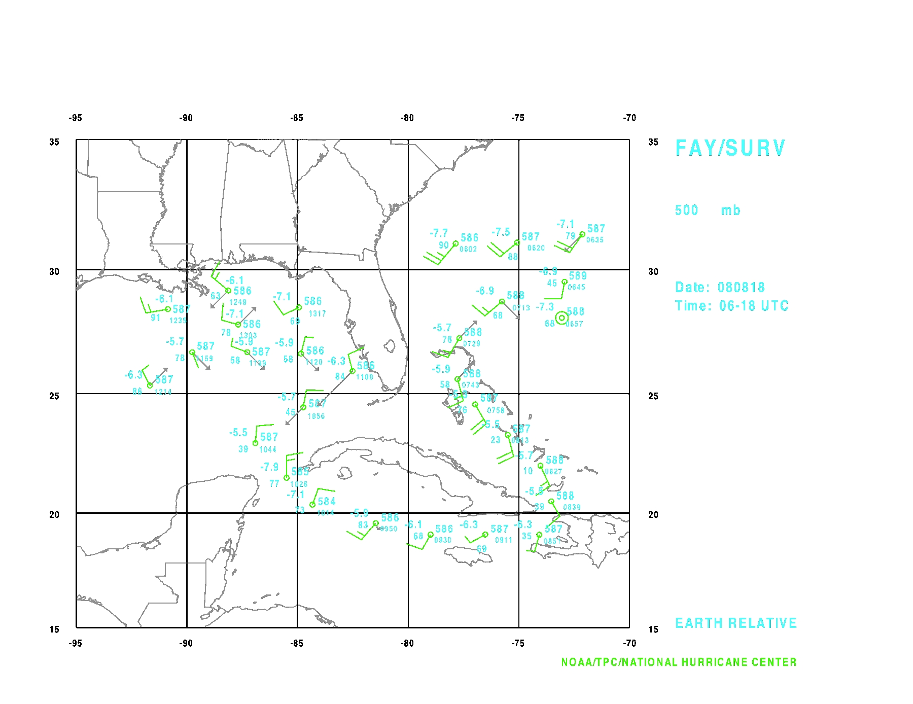
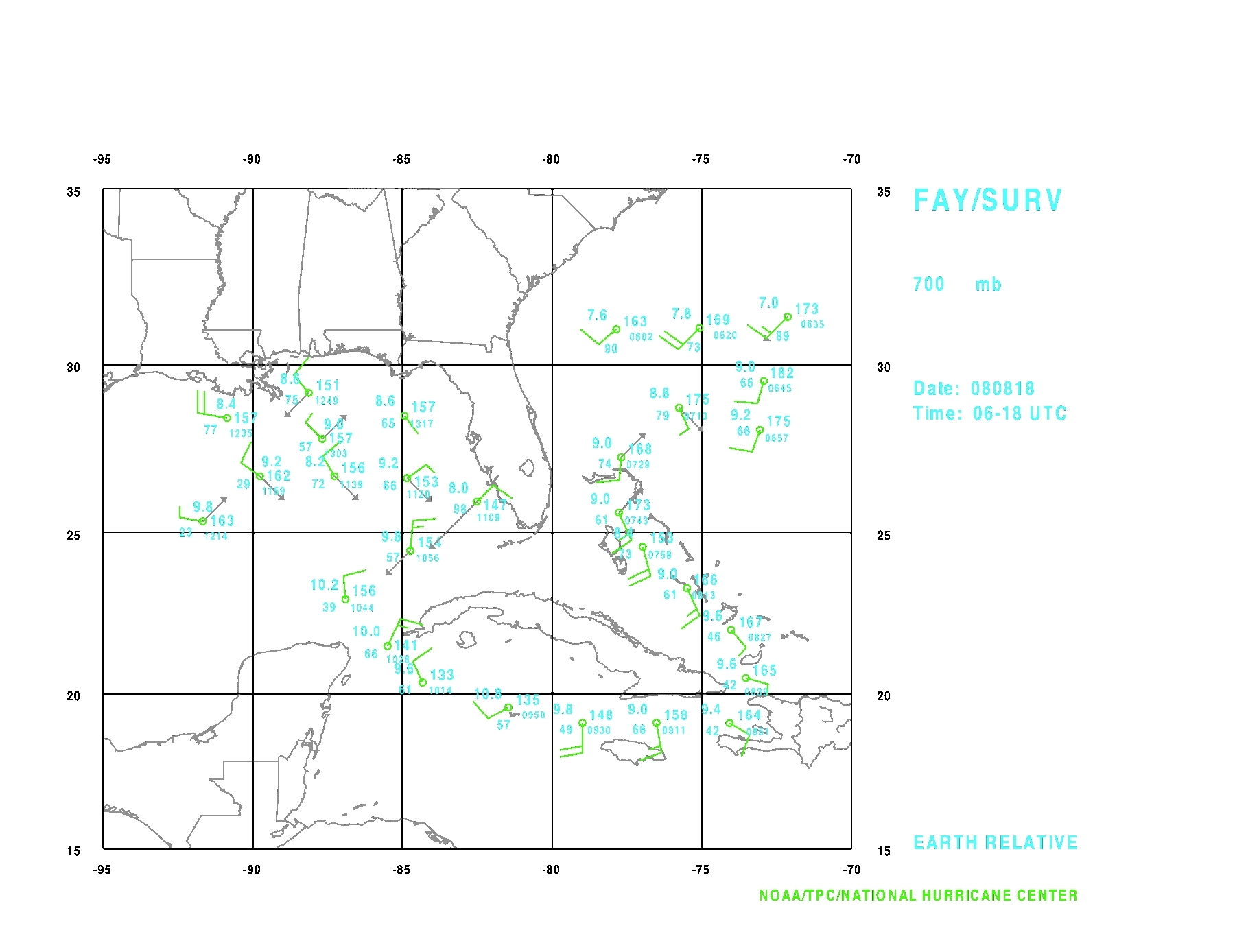
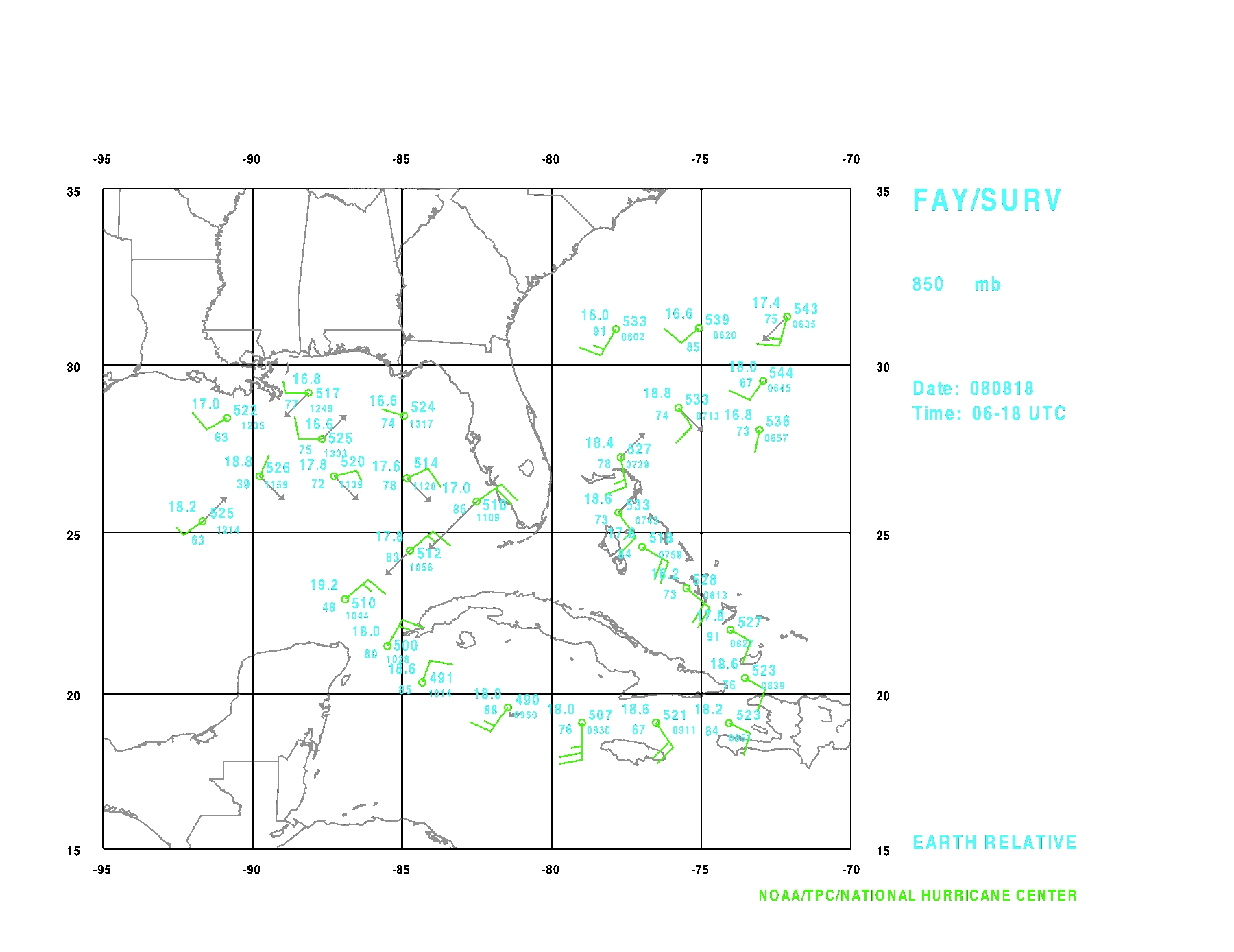
Figure 2 shows the synoptic maps of the observations at the mandatory levels.
During the flight we traversed a few areas of moderate convection, but did not
experience any significant turbulence. We landed back at MacDill about 1345
UTC. The final G-IV mission was scheduled for 1730 UTC on that same day.
100 mb
200 mb
500 mb
700 mb
850 mb

surface mb
Figure 2. Synoptic observations from the G-IV flight at the 150,200,500,
700,850 bb, and at the surface.
Problems :
Besides, the 3 sondes already mentioned, very few problems occurred during the
flight. There were a few failures of transmission of the TEMPDROP message but
thanks to X-chat capability with CARCAH, these were easily found and the data
was retransmitted successfully. There were a couple of problems running the
ASPEN software in which the heights were not coded properly or were missing.
Reprocessing these two sondes resulted in the corrected data being transmitted
and was confirmed by CARCAH.
Michael Black
09/02/08
Mission Data :
FDir manifest
Page last updated September 3, 2008
Return to Mission page.