Mission Summary
20020823N Aircraft 49RF
Synoptic Surveillance flight
around Tropical Storm Edouard 2002
Scientific Crew (43RF)
| Lead Scientist | S. Aberson |
| Visiting Scientists |
Ching-Hwang Liu
Po-Hsiung Lin
|
 Mission Plan :
The G-IV jet, with scientific crew of Sim Aberson and Taiwanese
scientists Ching-Hwang Liu and Po-Hsiung Lin, conducted an
NHC-tasked synoptic surveillance mission around TS Edouard at the
nominal time of 00 UTC/September 4. Take-off time was at 1:30 PM EDT
from MacDill AFB and landed at 10:15 PM EDT at MacDill, after a
successful synoptic surveillance mission.
Mission Summary :
NHC Specialist on duty, Richard Pasch, was called at 8:35 PM.
Important information relayed to specialist:
1. Beautiful flight level view of center.
2. Six sondes near center sent at beginning of flight, gale force
at surface. Did not get into center.
3. Little shear up to about 350 mb. Most of the shear above.
4. Very dry 500 mb and above over storm.
5. Little steering flow into Gulf of Mexico, though anticyclone
is evident.
6. 700-400 mb circulation displaced well east and northeast of
low-level center.
7. Very shallow circulation at 32N 76W (925 mb).
8. The Gulf has deep-layer moisture.
Problems :
1. Huge number of SATCOM failures.
2. Some communications problems between AVAPS and HAPS. First
eight sondes had to be resent from AVAPS to HAPS.
3. Difficulty in getting seven sondes out quickly near center.
4. AVAPS operator started a sonde on a channel before ending
sonde on same channel. Easily recovered.
5. SYNMAP does not work within Editsonde. It works on its own,
but is old and has no DLM plotting.
6. Editsonde seems to be the postprocessing version, not the
plane version (asks for user comments at the end).
PDF plots of drop data
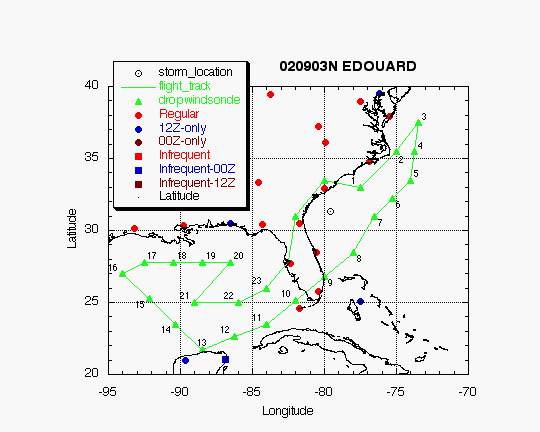
EDOUARD
HURRICANE SYNOPTIC SURVEILLANCE MISSION
Aircraft: N49RF Takeoff: 03/1730Z
Landed: 04/0200Z
|
DROP LOCATIONS |
| Drop # |
LAT
(d m) |
LON
(d m) |
TIME
(h:mm) |
| X1 | 31 00 | 82 00
| 0:26
|
| X2 | 33 30
| 80 00 | 0:51
|
| 3
| 33 00 | 77 30 | 1:10
|
| 4 | 35 30 | 75 00
| 1:38
|
| 5 | 37 30
| 73 30 | 1:57
|
| 6
| 35 30 | 73 45 | 2:14
|
| 7 | 33 30 | 74 00
| 2:30
|
| 8 | 32 15
| 75 15 | 2:44
|
| 9 | 31 00 | 76 30
| 2:58
|
| 10 | 28 30
| 78 00 | 3:22
|
| 11 | 26 49 | 80 00
| 3:42
|
| 12 | 25 10
| 82 00 | 4:03
|
| 13 | 23 30 | 84 00
| 4:24
|
| 14 | 22 37 | 86 15
| 4:43
|
| 15 | 21 45
| 88 30 | 5:02
|
| 16 | 23 30 | 90 19
| 5:22
|
| 17 | 25 15
| 92 10 | 5:42
|
| 18 | 27 00 | 94 00
| 6:03
|
| 19 | 27 45
| 92 30 | 6:16
|
| 20 | 27 45 | 90 30
| 6:31
|
| 21 | 27 45 | 88 30
| 6:46
|
| 22 | 27 45
| 86 30 | 7:02
|
| 23 | 25 00 | 89 00
| 7:31
|
| 24 | 25 00 | 86 00
| 7:55
|
| 25 | 26 00
| 84 00 | 8:12
|
EDOUARD
HURRICANE SYNOPTIC SURVEILLANCE MISSION
Aircraft: N49RF Takeoff: 03/1730Z
Landing: 04/0200Z
| TRACK DISTANCES |
| Drop # |
LAT
(d m) |
LON
(d m) |
LEG
(nm) |
TOTAL
(nm) |
TIME
(h:mm) |
| 0 | MACDILL | 0.
| 0. | 0:00
|
| 1 | 31 00 | 82 00
| 191. | 191. | 0:26
|
| 2 | 33 30 | 80 00
| 186. | 377. | 0:51
|
| 3 | 33 00 | 77 30
| 140. | 518. | 1:10
|
| 4 | 35 30 | 75 00
| 203. | 721. | 1:38
|
| 5 | 37 30 | 73 30
| 145. | 865. | 1:57
|
| 6 | 33 30 | 74 00
| 242. | 1107. | 2:30
|
| 7 | 31 00 | 76 30
| 204. | 1311. | 2:58
|
| 8 | 28 30 | 78 00
| 172. | 1482. | 3:22
|
| 9 | 23 30 | 84 00
| 454. | 1937. | 4:24
|
| 10 | 21 45 | 88 30
| 280. | 2217. | 5:02
|
| 11 | 27 00 | 94 00
| 445. | 2662. | 6:03
|
| 12 | 27 45 | 92 30
| 96. | 2758. | 6:16
|
| 13 | 27 45 | 86 30
| 339. | 3097. | 7:02
|
| 14 | 25 00 | 89 00
| 218. | 3314. | 7:31
|
| 15 | 25 00 | 86 00
| 171. | 3486. | 7:55
|
| 16 | 26 00 | 84 00
| 129. | 3615. | 8:12
|
| 17 | MACDILL
| 139. | 3754. | 8:31
|
Return to Mission page.