Mission Summary
20020903I Aircraft 43RF
Two plane CBLAST mission into Tropical Storm Edouard
Scientific Crew (43RF)
| Lead Scientist | P. Black |
| AXBT Scientist | E. Uhlhorn |
| Radar scientist | M. Black |
| GPS Dropsonde | M. Black |
| HRD Workstation | M. Black |
| FRD BAT probe | S. White |
| SRA | Ed Walsh (NASA) |
| PMS/CIP probes | not installed
not operating |
| Scripps laser alt. | not operating |
Mission Briefing:
This mission was designed to test the hurricane planetary
boundary layer (PBL) flight pattern in weak tropical storm
conditions, to flight test new CBLAST instrumentation in wind and
rain and to execute BAT probe calibration maneuvers.
A two-plane CBLAST/Ocean Winds research mission in TS Edouard was
scheduled for September 3, 2002, departing MacDill AFB at 1 PM EDT
and recovering at MacDill approximately 6.5 hours later.
N42RF and N43RF will fly coordinated, stacked figure-4 patterns at
3,000 and 5,000 feet, or alternately at 5,000 and 7,000 feet.
N42RF will then execute two step-descent patterns, while N43RF
flies overhead.
Mission Synopsis
Detailed mission briefings were held with AOC flight directors
and navigators one hour before the flight brief to discuss any
problems with the flight segments being planned. A detailed
briefing was then held two hours prior to the mission to discuss
the CBLAST mission profile with lead mission scientists, flight
directors, pilots, navigators, flight engineers and SED chief
electronics engineers.
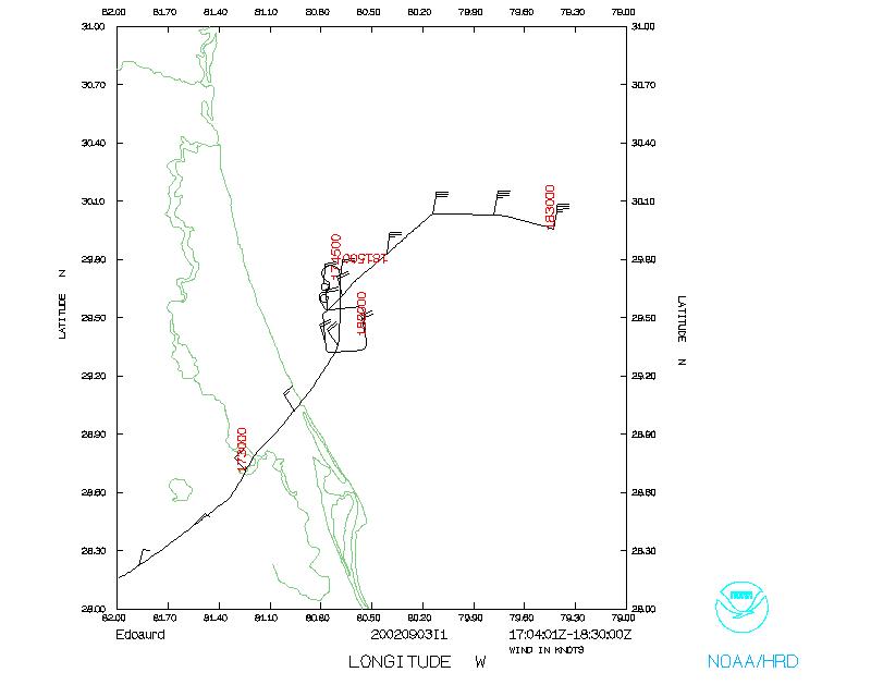
NOAA43 departed MacDill on time at 1707 GMT followed 20 minutes
later by NOAA42. NOAA42 returned to MacDill at 2330 followed one
hour later by NOAA43, durations of 6 hr, 15 min and 7 hr, 30 min,
respectively. Three AXBTs were deployed from NOAA43 and one GPS
dropsonde in the figure 4 pattern as well as 4 GPS sondes in the
eyewall/rainband. NOAA42 deployed 8 GPS drops in the eyewall/rainband
as well as 4 GPS/AXBT combo drops in the figure 4 pattern.
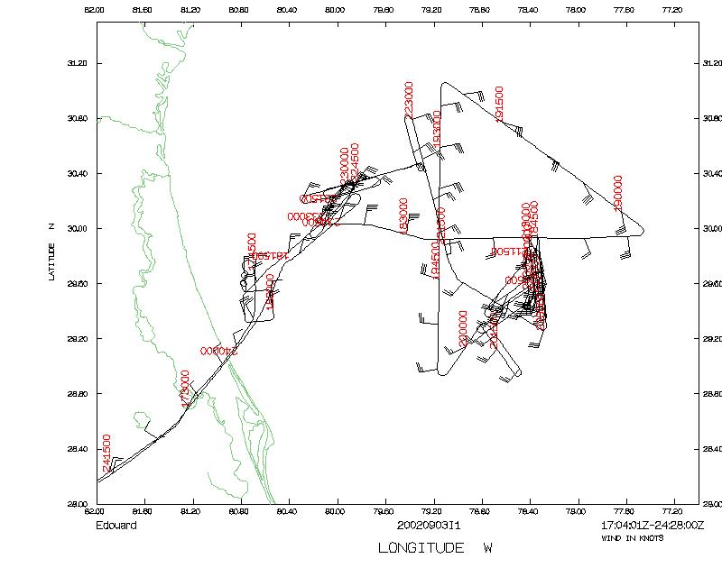
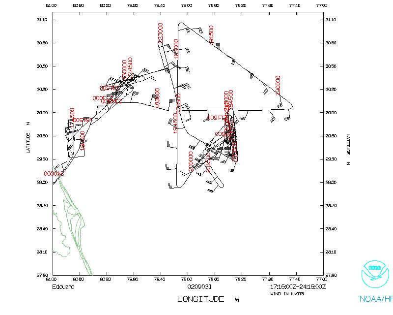
NOAA43 flew the BAT probe calibration maneuvers at 1,000 ft near
NDBC buoy 41012 enroute to the IP while waiting for NOAA42 to
catch up, i.e. clockwise and counterclockwise circles at 30°
bank followed by a wind box with two minute legs. NOAA42 then
arrived and the aircraft linked patterns with NOAA42 trailing
NOAA43 by 2-4 nm, or about 30-60 seconds flight time. Flight
altitudes were 7,000 ft for NOAA42 and 1,000 ft for NOAA43,
except for 5,000 ft during the rainband/eyewall segment
penetration during the 'figure 4' portion of the flight. The leg
lengths of the figure 4 pattern were 60 nm.
The intense convective band on the east side of the storm was
penetrated by both aircraft. Peak reflectivities were 45 dBZ.
Peak penetrated reflectivities were 35-40 dBZ. Band thickness was
about 30 nm resulting in about 7 minutes duration in the band.
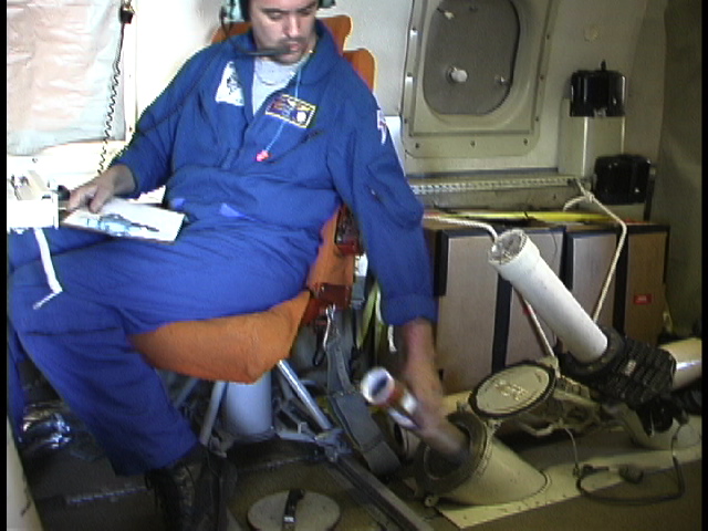 The deployment of 12 sondes in rapid succession was executed by
the two aircraft with NOAA42 initiating their 8 sonde deployment
sequence just prior to entering the convection. Due to
depressurization for free fall launching of AXBTs, insufficient
differential pressure was available for GPS sonde deployment and
the first sonde stuck in the tube. Subsequent sondes were hand
launched out the AXBT free-fall chute. About 30 seconds later,
NOAA43 began its sequence of 4 GPS sonde deployments from 5,000
ft with 10-20 seconds between drops. The problem on NOAA42
resulted mainly from HRD personnel delivering AXBTs planeside
late prior to take-off which resulted in external tube loading
difficulties. This necessitated loading of AXBT's inside of the
aircraft and a subsequent free-fall launching method.
The deployment of 12 sondes in rapid succession was executed by
the two aircraft with NOAA42 initiating their 8 sonde deployment
sequence just prior to entering the convection. Due to
depressurization for free fall launching of AXBTs, insufficient
differential pressure was available for GPS sonde deployment and
the first sonde stuck in the tube. Subsequent sondes were hand
launched out the AXBT free-fall chute. About 30 seconds later,
NOAA43 began its sequence of 4 GPS sonde deployments from 5,000
ft with 10-20 seconds between drops. The problem on NOAA42
resulted mainly from HRD personnel delivering AXBTs planeside
late prior to take-off which resulted in external tube loading
difficulties. This necessitated loading of AXBT's inside of the
aircraft and a subsequent free-fall launching method.
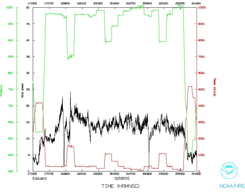
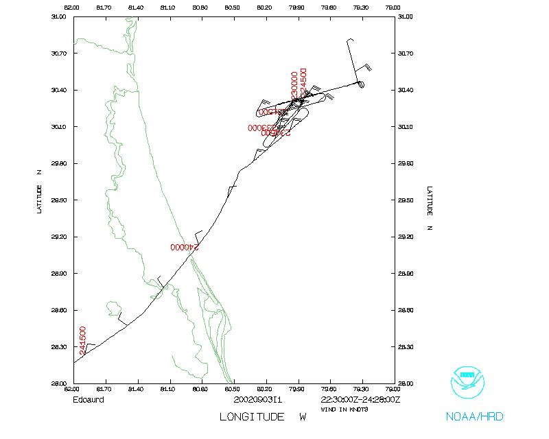
Following completion of the figure 4 on the south side of the
storm, NOAA43 then began the first of two boundary layer stepped
descent patterns while NOAA42 flew across convective bands in
between stepped descents. The two aircraft flew 5-6 min legs
radially outbound and then inbound from the two initial points 40
nm southeast of the center and 40 nm northwest of the center at
an indicated airspeed of 220 kt (penetration airspeed). NOAA43
flew at 600 ft while NOAA43 flew at 7,000 ft.
Following the cross wind pattern, NOAA43 climbed to 3500 ft and
began the along wind flight legs, downwind for 5 minutes, upwind
for 6 minutes. Weather in the southeast was shallow towering
cumulus with some light rain showers. Surface winds were about 30
kt. Upwind downwind legs were then flown at 2,000, 1,000, 600,
400 and 200 ft during the along wind portion of the PBL pattern.
NOAA43 then proceeded through the center to execute a similar
cross wind and stepped descent sequence on the northwest side of
the storm in surface winds of about 30 kt. Turbulence levels felt
somewhat stronger on the NW compared to the SE.
The coordinated pattern was flown nearly flawlessly by AOC crew.
The only problem was too many airspeed changes by both aircraft
in an effort to maintain precise lateral aircraft separation.
This resulted in frequent aircraft pitch changes with affected
tail Doppler radar and IWRAP data.
Problems:
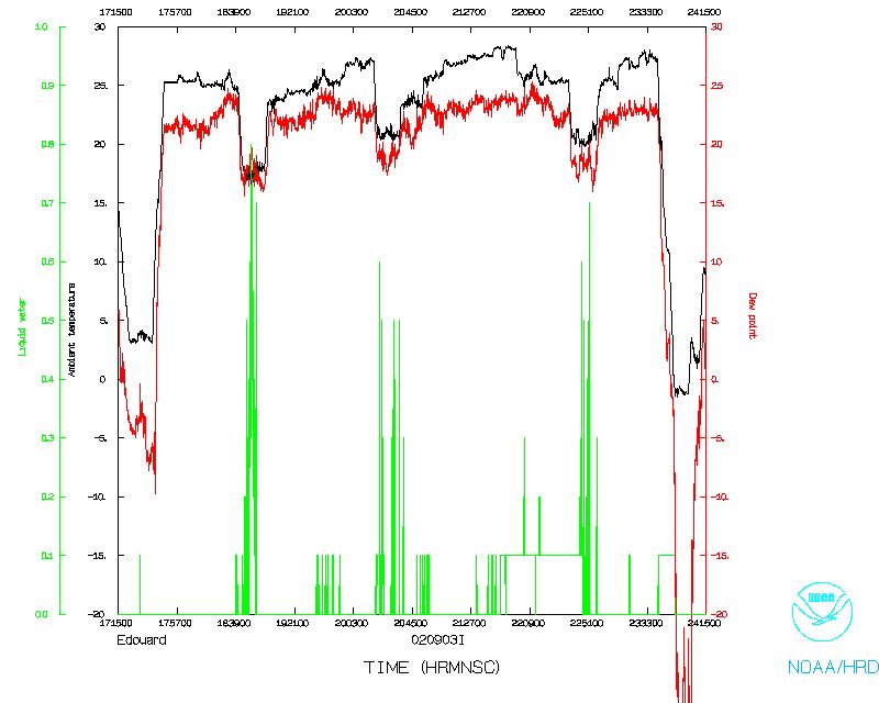
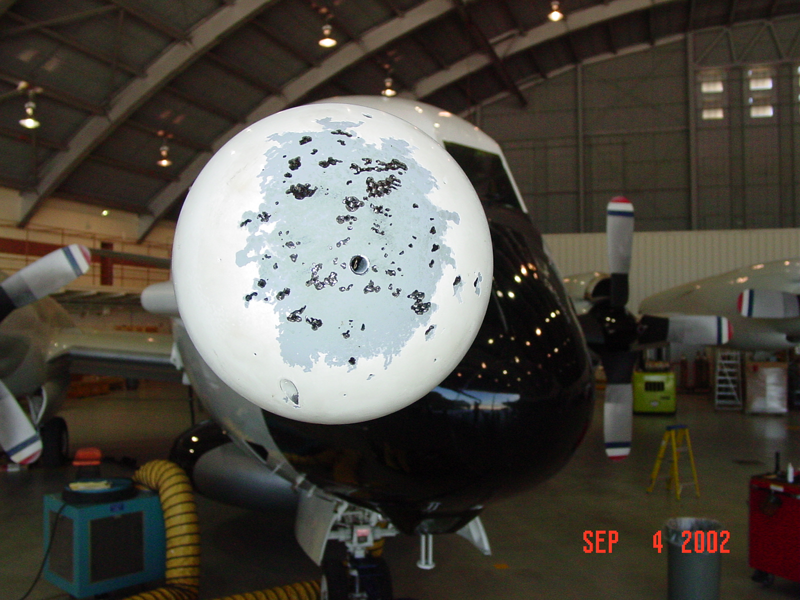 A major problem was encountered with the BAT probe on this
flight. The short period of rainfall caused extensive damage to
the probe spherical head, pulverizing the paint, outer gel coat
and inner composite material. The probe was removed from the
aircraft after the flight and shipped to FRD for repair and
redesign.
A major problem was encountered with the BAT probe on this
flight. The short period of rainfall caused extensive damage to
the probe spherical head, pulverizing the paint, outer gel coat
and inner composite material. The probe was removed from the
aircraft after the flight and shipped to FRD for repair and
redesign.
The SFMR on NOAA43 experienced significant radio frequency
interference (RFI) at the altitudes below 5,000 ft. Terry Lynch
was able to diagnose the source of this contamination as coming
from the TA X-band radar on NOAA43, which contaminated the 6.02
and 7.20 GHz frequencies and the C-band altimeter, which
contaminated the 5.06 GHz frequency. It was found that the
onboard processing software did not have the software installed
to eliminate contaminated frequencies. The needed software is
being installed by Al Goldstein of AOC. Future flights should
therefore be able to compute surface winds as usual using fewer
frequencies from low flight altitudes despite the RFI. AOC
engineers will investigate why filters previously installed on
the C-band altimeter failed to prevent RFI and also why an X band
tail radar is transmitting energy at the high end of the C-band
frequency range.
A slight problem with the flight plan was experienced. The along
wind, stepped descent part of the pattern tended to drift down
stream with time, indicating that legs on the downwind segments
were too long and too short on the upwind segments. Timing will
have to be adjusted in the future, especially at higher winds.
Downwind legs will need to be shortened and upwind legs
lengthened. Also, a heading change may be required at leg
midpoints to keep the aircraft track aligned with the changing
wind direction. Along wind legs should be flown at close to zero
drift angle.
Peter Black
Lead Scientist
Mission Data
One minute listing
PDF plots of dropsonde data
EDOUARD
HURRICANE SYNOPTIC SURVEILLANCE MISSION PLAN
Aircraft: N43RF Proposed takeoff: 03/1700Z
| TRACK DISTANCES |
| Drop # |
LAT
(d m) |
LON
(d m) |
LEG
(nm) |
TOTAL
(nm) |
TIME
(h:mm) |
| 0 | MACDILL | 0. |
0. | 0:00 |
| 1 | 31 00 | 79 30 |
254. | 254. | 1:03 |
| 2 | 31 00 | 78 30 |
56. | 309. | 1:17 |
| 3 | 31 00 | 77 30 |
56. | 365. | 1:31 |
| 4 | 32 00 | 78 30 |
82. | 446. | 1:51 |
| 5 | 31 00 | 78 30 |
60. | 506. | 2:06 |
| 6 | 30 00 | 78 30 |
60. | 566. | 2:21 |
| 7 | 30 15 | 77 45 |
44. | 611. | 2:32 |
| * 8 | 30 40 | 77 45 |
25. | 636. | 2:39 |
| 9 | 31 00 | 78 30 |
46. | 682. | 2:50 |
| 10 | 31 20 | 79 15 |
46. | 728. | 3:02 |
| * 11 | 31 00 | 79 15 |
20. | 748. | 3:07 |
| 12 | MACDILL | 263. |
1011. | 4:12 |
* Perform CBLAST step-descent pattern (Fig. 8 of HFP 2002 plan)
Return to Mission page.