HURRICANE SYNOPTIC SURVEILLANCE MISSION PLAN: HURRICANE EARL
Prepared by the
National Hurricane Center
August 30, 2010 11:06:31 AM
Aircraft: N49RF
Altitude: FL410-450
Proposed takeoff: 31/1730Z
| |
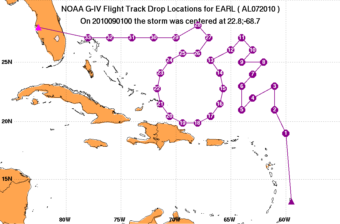
DROP LOCATIONS
|
| #
| LAT
| LON
| TIME
|
|
| deg min
| deg min
| hh:mm
| | 1 | 19 00 | -60 00 | 0:49
| | 2 | 21 00 | -61 00 | 1:07
| | 3 | 23 00 | -61 00 | 1:23
| | 4 | 22 00 | -63 00 | 1:41
| | 5 | 21 00 | -64 00 | 1:52
| | 6 | 23 00 | -64 00 | 2:09
| | 7 | 24 00 | -63 00 | 2:20
| | 8 | 25 00 | -62 00 | 2:31
| | 9 | 25 00 | -64 00 | 2:47
| | 10 | 26 00 | -63 00 | 2:58
| | 11 | 27 00 | -64 00 | 3:10
| | 12 | 26 00 | -65 00 | 3:21
| | 13 | 25 09 | -66 50 | 3:37
| | 14 | 24 06 | -66 00 | 3:47
| | 15 | 22 48 | -65 42 | 3:58
| | 16 | 21 30 | -66 00 | 4:09
| | 17 | 20 27 | -66 50 | 4:20
| | 18 | 19 53 | -68 02 | 4:31
| | 19 | 19 53 | -69 22 | 4:41
| | 20 | 20 27 | -70 34 | 4:52
| | 21 | 21 30 | -71 24 | 5:03
| | 22 | 22 48 | -71 42 | 5:14
| | 23 | 24 06 | -71 24 | 5:24
| | 24 | 25 09 | -70 34 | 5:35
| | 25 | 25 43 | -69 22 | 5:46
| | 26 | 25 43 | -68 02 | 5:56
| | 27 | 27 00 | -67 00 | 6:09
| | 28 | 28 00 | -68 00 | 6:20
| | 29 | 27 00 | -70 00 | 6:38
| | 30 | 27 00 | -72 00 | 6:53
| | 31 | 27 00 | -74 00 | 7:09
| | 32 | 27 00 | -76 00 | 7:24
| | 33 | 27 00 | -78 00 | 7:40
| |
HURRICANE SYNOPTIC SURVEILLANCE MISSION PLAN: HURRICANE EARL
Prepared by the
National Hurricane Center
August 30, 2010 12:08:37 PM
Aircraft: NAJRF
Altitude: FL410-450
Proposed takeoff: 31/1730Z
| |
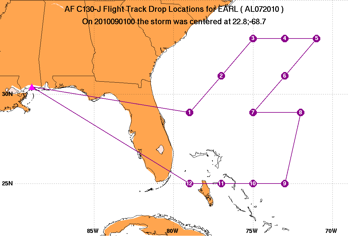
DROP LOCATIONS
|
| #
| LAT
| LON
| TIME
|
|
| deg min
| deg min
| hh:mm
| | 1 | 29 00 | -79 00 | 1:45
| | 2 | 31 00 | -77 00 | 2:16
| | 3 | 33 00 | -75 00 | 2:47
| | 4 | 33 00 | -73 00 | 3:07
| | 5 | 33 00 | -71 00 | 3:28
| | 6 | 31 00 | -73 00 | 3:58
| | 7 | 29 00 | -75 00 | 4:29
| | 8 | 29 00 | -72 00 | 5:01
| | 9 | 25 00 | -73 00 | 5:47
| | 10 | 25 00 | -75 00 | 6:08
| | 11 | 25 00 | -77 00 | 6:30
| | 12 | 25 00 | -79 00 | 6:51
|
|