Mission Summary
20080722N1 Aircraft 49RF
Dolly flight 2008
Aircraft Crew (49RF)
| Aircraft Commander | Jeff Hagen |
| Pilots | Will Odell
Gregg Glover
|
| Flight Director | Tom Shepherd |
| Data System | Dale Carpenter |
| AVAPS | Jim Roles
Gabe Defeo |
| Dropsonde Scientist | Jason Dunion |
Mission Plan :
NOAA 49RF will fly a Synoptic Surveillance Mission around Tropical Storm Dolly.
The G-IV will leave MacDill AFB at 0530 UTC and recover at MacDill at 1330 UTC.
The flight track will take the G-IV on a clockwise circumnavigation of the TC
and is shown in Fig. 1, along with the 32 GPS dropsonde points.
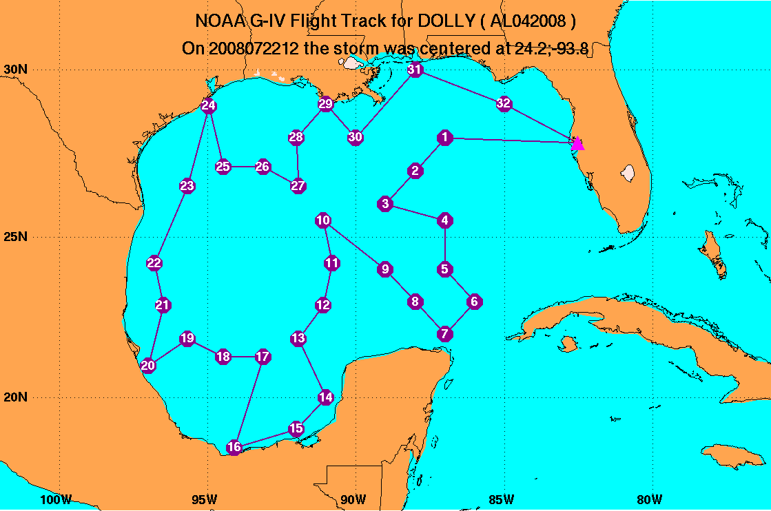
Fig. 1: Flight track (blue line) for Synoptic Surveillance mission
20080831N1. The GPS dropsonde points (32 total) are indicated by numbered
circles.
Synoptic Surveillance
MISSION PLAN
DOLLY
July 21, 2008 12:16:40 PM
Aircraft: N49RF
Altitude: FL410-450
Proposed takeoff: 22/0530Z
|
DROP
#
| LAT
(d m)
| LON
(d m)
| TIME
(h:mm)
|
| 1 | 28 00 | -87 00 | 0:34
|
| 2 | 27 00 | -88 00 | 0:46
|
| 3 | 26 00 | -89 00 | 0:57
|
| 4 | 25 30 | -87 00 | 1:13
|
| 5 | 24 00 | -87 00 | 1:25
|
| 6 | 23 00 | -86 00 | 1:37
|
| 7 | 22 00 | -87 00 | 1:48
|
| 8 | 23 00 | -88 00 | 1:59
|
| 9 | 24 00 | -89 00 | 2:11
|
| 10 | 25 30 | -91 06 | 2:31
|
| 11 | 24 12 | -90 48 | 2:42
|
| 12 | 22 54 | -91 06 | 2:53
|
| 13 | 21 51 | -91 56 | 3:04
|
| 14 | 20 00 | -91 00 | 3:21
|
| 15 | 19 00 | -92 00 | 3:32
|
| 16 | 18 24 | -94 06 | 3:49
|
| 17 | 21 17 | -93 08 | 4:14
|
| 18 | 21 17 | -94 28 | 4:25
|
| 19 | 21 51 | -95 40 | 4:35
|
| 20 | 21 00 | -97 00 | 4:48
|
| 21 | 22 54 | -96 30 | 5:04
|
| 22 | 24 12 | -96 48 | 5:15
|
| 23 | 26 33 | -95 40 | 5:36
|
| 24 | 28 57 | -94 58 | 5:56
|
| 25 | 27 07 | -94 28 | 6:12
|
| 26 | 27 07 | -93 08 | 6:22
|
| 27 | 26 33 | -91 56 | 6:32
|
| 28 | 28 00 | -92 00 | 6:44
|
| 29 | 29 00 | -91 00 | 6:55
|
| 30 | 28 00 | -90 00 | 7:07
|
| 31 | 30 00 | -88 00 | 7:29
|
| 32 | 29 00 | -85 00 | 7:53
|
Mission Summary :
a) Synoptic Situation
Tropical Storm Dolly was located in the western Gulf of Mexico and postioned
approximately due south of a deep layer ridge (centered over eastern
Texas/western Louisiana). Upper-level outflow was quite impressive around the
western and northern semi-circles of the storm, but was being impeded on the
east and southeast sides by an upper-level low located over the Bay of
Campeche. Not surpisigly, GOES IR imagery indicated that convection was
concentrated around the western and northern semi-circles and somewhat stifled
on the east and southeast sides of the storm.
b) Mission Specifics
Takeoff was at 0537 UTC from MacDill. After the first few dropsondes were
successfully transmitted off the plane, transmissions of the TEMPDROP messages
began repeatedly failing. The HRD dropsonde scientist worked closely with the
G-IV data system specialist to determine the cause of the data transmission
failures and unsuccessfully attempted to use a backup data transmission method
to send the TEMPDROPS messages off the plane. A last resort method of emailing
each individual TEMPDROP message directly to NCEP did work successfully and was
used to send off the remaining 25-30 TEMPDROP messages from the aircraft.
GPS dropsonde data from 200 hPa clearly indicated Dolly's strong outflow to
the north and restricted outflow to the south and southeast. Dropsonde data
from 150-300 hPa also suggested that the strong inflow to the north of the
storm was relatively shallow and restricted mainly to a layer from 200-250 hPa.
Additionally, dropsonde data of 500 hPa winds and heights indicated the
presence of the deep layer ridge north of Dolly that was also clearly
stretched into the northeast Gulf of Mexico behind the storm.
Moderate clear air turbulence was encountered from drop points #15-32 and was
a result of the aircraft flying through 35-55 kt winds associated with Dolly's
upper-level outflow.
Problems :
The real-time transmission of GPS dropsonde TEMPDROP messages was particularly
challenging during this mission. The backup method of emailing individual
TEMPDROPS messages directly to NCEP was successful, though quite time
consuming. Surprisingly, several of the new UBLOX dropsondes failed during
the mission: 2 dropsondes had no launch detect, 2 dropsondes were fastfalls,
and 2 dropsondes had no winds. Of the 36 dropsondes launched during the
mission, 32 were successfully transmitted off the plane.
Mission Data :
FDir manifest |
Dropsonde catalog
Pressure height maps of dropsonde data
100mb map
200mb map
250mb map
300mb map
400mb map
500mb map
700mb map
850mb map
925mb map
1000mb map
surface map
Page last updated July 29, 2008
Return to Mission page.