Mission Summary
20080720H1 Aircraft 42RF
NCEP-Tasked Dolly investigative flight 2008
Scientific Crew (42RF)
| Lead Scientist | Mike Black |
| Dropsonde Scientist | Sylvie Lorsolo |
| Doppler Scientist | John Gamache |
| UMass Scientist | J. Manus |
| UMass Scientist | T. Chu |
Flight Crew (42RF)
| Pilots | Barry Choy
Al Ginamonte |
| Flight Director | Barry Damiano |
| Navigator | Joe Bishop |
| Flt. Eng. | Greg Bast
Steve Wade |
| Data Tech | Bobby Peek |
| Elec. Tech | Bill Olney
Joe Bosko |
Mission Plan :
Prior to the flight, the system of interest was classified by NHC as AL94, a
strong tropical wave in the east-central Caribbean. The mission was to be a
genesis mission with a proposed zig-zag pattern along the wave axis flown at
12000 feet altitude. The mission was tasked by NCEP and was also of keen
interest for the genesis experiment of NOAA's IFEX. The mission was scheduled
around the nominal synoptic time of 1200 UTC with a proposed takeoff of 0800
UTC from MacDill AFB. The mission duration would be about 8 hours with a
landing back at MacDill. The center of the wave axis was located near
18°N, 84°W. Follow-on missions at 12-hour intervals were planned with
N43 and N42.
Mission Summary :
| Take off
| Landing
| MacDill AFB
| 08:19 UTC
| MacDill AFB
| 17:23 UTC
| |
Takeoff was a bit late at 0819 UTC and N42 headed south to fly around the
western tip of Cuba (NOAA did not have Cuba over flight clearance). The ferry
down was conducted at 600 mb (~12000 ft) and we dropped 3 GPS sondes from that
altitude in route to the wave center. N42 headed ESE from western Cuba to
approach the wave axis from the NE. The aircraft encountered large areas of
stratiform precipitation with some small areas of convection along the way. At
1135 UTC we reached the NE point and headed SW toward the apparent wave center,
which was reached at 1153 UTC where a sonde was dropped. N42 tracked south from
this center at reached the south point, about 105 nmi away at 1242 UTC. During
this southward leg, we were notified by CARCAH that we would be doing a center
fix for NHC at an altitude of 1500 feet. This fix responsibility resulted in a
major change to the planned pattern but would still allow good radar coverage
of the wave. We decided to fly the inner portion of the pattern at 1500 ft
but to climb back to 12000 ft to drop sondes at the leg endpoints. The descent
to 1500 ft was at 1235 UTC where we headed to a point about 105 nmi east of
the NHC-estimated center. The eastern point was at 1316 UTC and we remained at
1500 ft, where the plane tracked west toward the new (low-level) center, which
was reached at 1347 UTC. The area west of the center was almost precipitation
free. From this center, N42 tracked to the west for a short leg of about 60 nmi
length. Our final pass through the center was a leg from SW to NE starting at
1425 UTC, reaching the center at 1443 UTC and ending within an area of
convection about 60 nmi NE of the center at 1458 UTC. The plane climbed back up
to 600 mb at 1500 UTC and headed NE towards western Cuba for the ferry back to
base. Three more sondes were dropped along this leg through the eastern edge
of the cloud shield. N42 landed back at MacDill at 1723 UTC. Data from our
flight caused NHC to upgrade AL94 from a wave to TS Dolly and the first
advisory was written on Dolly at 1545 UTC, during N42Ős ferry back to base.
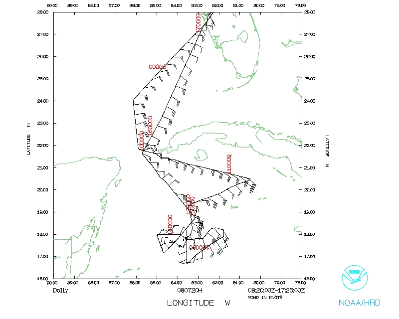
Figure 1 shows the flight track and precipitation pattern from the LF radar.
The system appeared disorganized with little amount of banding evident. The
strongest convection was located well to the north of the low-level center
(1443) with a very large area of mainly stratiform precipitation north and
east of this center. Areas south and east of the center were mainly rain free.
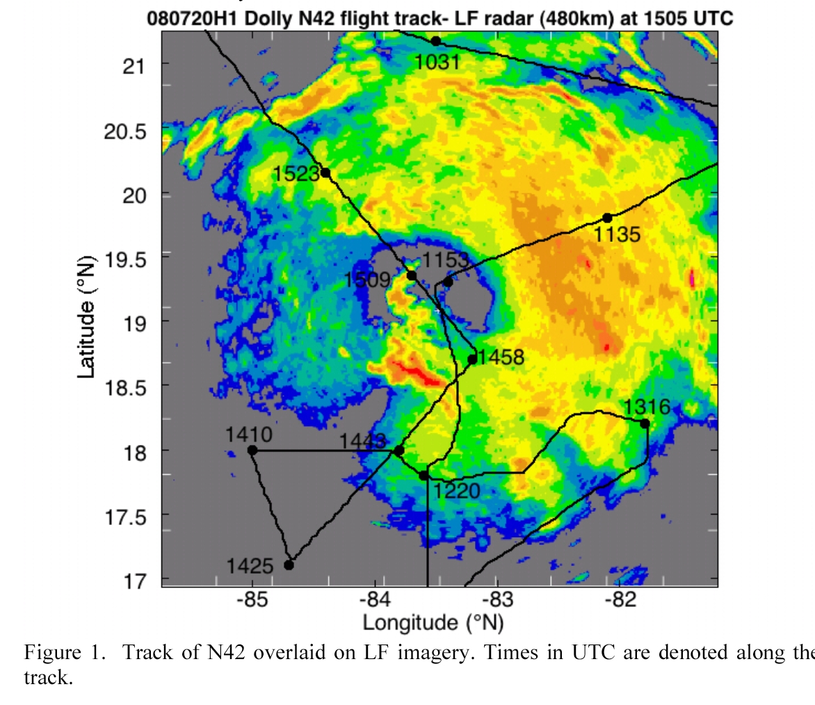
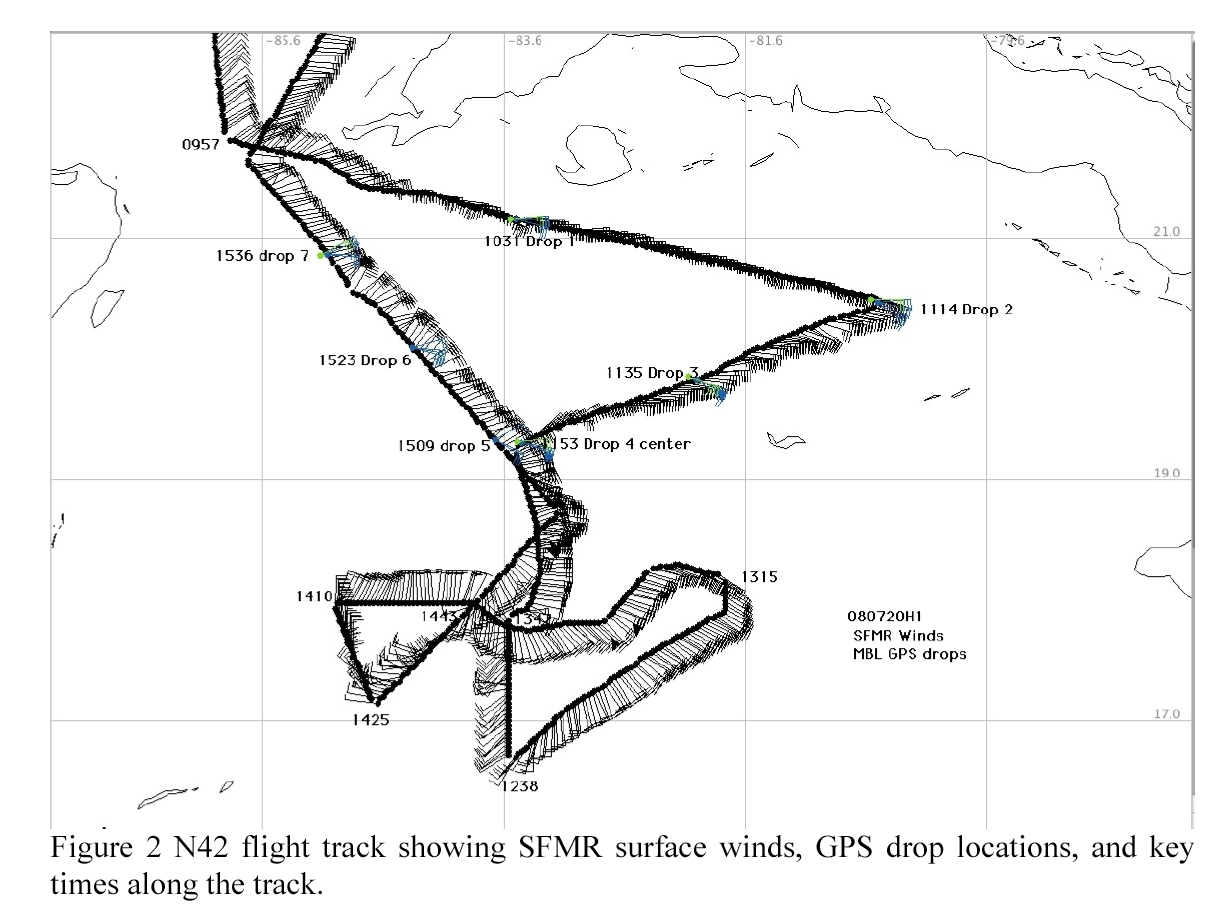
Figure 2 shows the flight-track with SFMR surface wind barbs (kt) along the
track and locations of the 7 dropsondes. Drop 4 at 1153 was at the apparent
center at 600 mb and was significantly displaced from the low-level center
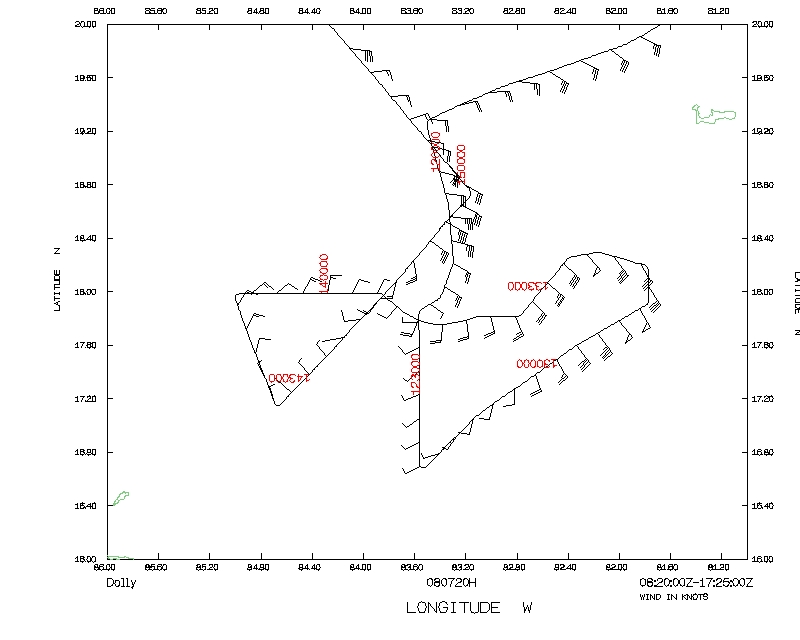
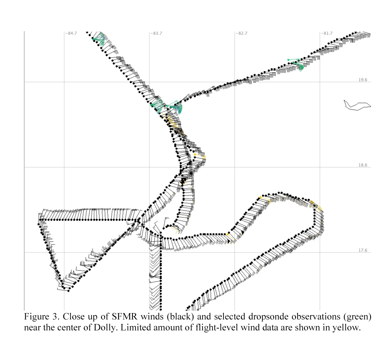
further to the south. Figure 3 is a close up of the SFMR and dropsonde wind
observations near the low-level center.
SFMR and flight-level winds were >50 kt NE and SE of the center but were only
5-15 kt west and south of the center. Nevertheless, the wind data showed a
well-defined low-level circulation center with winds greater than tropical
storm force. It was these observations that caused NHC to upgrade AL94 from
a wave to Tropical Storm Dolly.
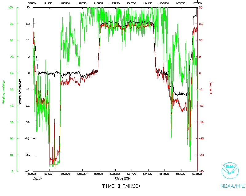
Problems :
The radar, flight-level, SFMR, and dropsonde systems all worked well on this
flight. All seven dropsondes were good. The tasking for a center fix altered
the planned pattern and, more importantly, the altitude that we flew the
mission at. Nevertheless, we were able to collect LF and tail radar data
through almost all of the precipitation areas and collected flight level, SFMR,
and some sonde data in both cloudy and clear areas of this system. We attempted
to perform real-time Doppler analyses on some of the legs, but encountered
problems with the software angle checking due to our low altitude. This
problem was to be addressed before subsequent flights.
Michael Black
07/30/08
Mission Data
NetCDF listing |
Error Summary |
1 second listing<>
Page last updated August 27, 2008
Return to Mission page.