Mission Summary
20050710I1 Aircraft 43RF
Dennis flight 2005
Scientific Crew (43RF)
| Mike Black | LPS |
| Paul Willis | Cloud Physics |
| Eric Uhlhorn | AXBT |
| Krystal Valde | Workstation |
| L. Tucker | Observer |
| G. Sutton | Observer |
Aircraft Crew (43RF)
LCDR Randy TeBeest
LCDR Mark Nelson | Pilots |
| LT Devin Brakob | Navigator |
Marty Mayeaux
Tom Shepherd |
Flight Directors |
| Dewie Floyd | Flight Engineer |
| Terry Lynch | Data Tech |
| Bill Olney | AVAPS |
| Damon San Souci | Avionics |
| Randy Mitchell | Crew Chief |
| James McFadden | Observer |
| LT Eric Berkowitz | Observer |
Mission Plan :
This mission was the first of two consecutive HRD landfall research
missions designed to document intensity and structural changes associated
with the interaction of Dennis with land. NOAA43 should arrive before the
eyewall reaches the northern Gulf coast while NOAA42 would fly right after
43 leaves the area to document the changes in structure while Dennis was
moving inland. Hurricane Dennis had rapidly intensified during the
afternoon and night of July 4 from a Category 2 to Category 4 hurricane.
The deepening ceased during the morning of 10 July but Dennis was forecast
to be a major hurricane at landfall near Pensacola, Florida during the
afternoon. In addition to sampling the highest winds in the eyewall, NOAA
43 would fly a combination of legs along the coast to gather important
SFMR surface wind data near landfall and in support of research wind towers
that were deployed by University colleagues at various coastal locations
along Dennis's projected track. The aircraft would also attempt to release
a series of dropsondes in high winds in a leg oriented perpendiculars to
the coast and with spacing about 5 miles apart from about 25- 5 miles off
the coast. The aircraft track would also take us over Buoys 42036 in the
eastern Gulf and 42039 further to the NW, hopefully during the closest
approach of the eyewall to Buoy 42039. GPS sondes and AXBTs would be
released over the Buoys to compare with the observations collected on 43's
flight the day before. The flight altitude would be 12,000 ft, takeoff and
recovery would be in Jacksonville, Florida and we planned on dropping
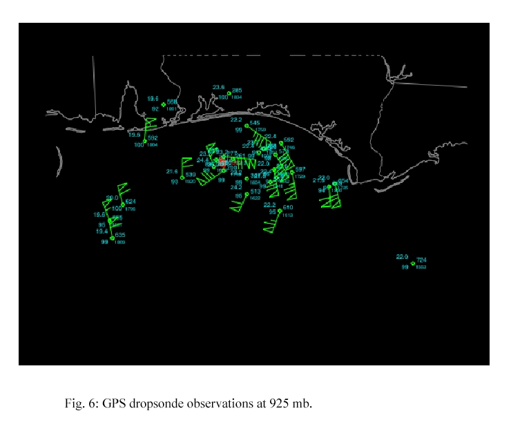
about 35 GPs sondes and 3 AXBTs.
Mission Summary :
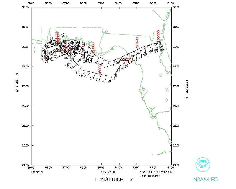
 Takeoff from Jacksonville was at 1501 UTC and NOAA43 headed westward for the
Initial Point (IP) at Buoy 42036. At 1532 UTC the aircraft encountered a
vigorous rainband just offshore from the west coast of Florida and about
175 nmi east of the center of Hurricane Dennis. We reached Buoy 42036 at
1553 UTC and released a GPs sonde and AXBT. The winds failed on the sonde
and the AXBT recorded a SST of 28.5°C. The aircraft then headed NW toward
Buoy 42039 which was reached at 1613 UTC. The buoy was located well
outside of the eyewall and flight-level winds were about 60 kts while a
GPS sonde and the SFMR recoded surface winds of about 50 kts. The AXBT
released over the Buoy measured an SST of 26.5°C, about 2 degrees cooler
then on the daybefore.
Takeoff from Jacksonville was at 1501 UTC and NOAA43 headed westward for the
Initial Point (IP) at Buoy 42036. At 1532 UTC the aircraft encountered a
vigorous rainband just offshore from the west coast of Florida and about
175 nmi east of the center of Hurricane Dennis. We reached Buoy 42036 at
1553 UTC and released a GPs sonde and AXBT. The winds failed on the sonde
and the AXBT recorded a SST of 28.5°C. The aircraft then headed NW toward
Buoy 42039 which was reached at 1613 UTC. The buoy was located well
outside of the eyewall and flight-level winds were about 60 kts while a
GPS sonde and the SFMR recoded surface winds of about 50 kts. The AXBT
released over the Buoy measured an SST of 26.5°C, about 2 degrees cooler
then on the daybefore.
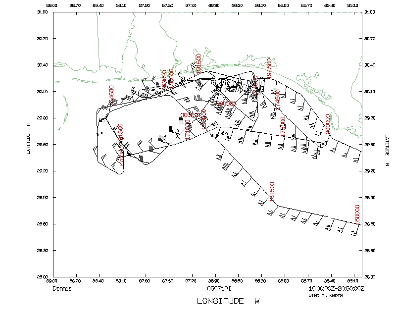
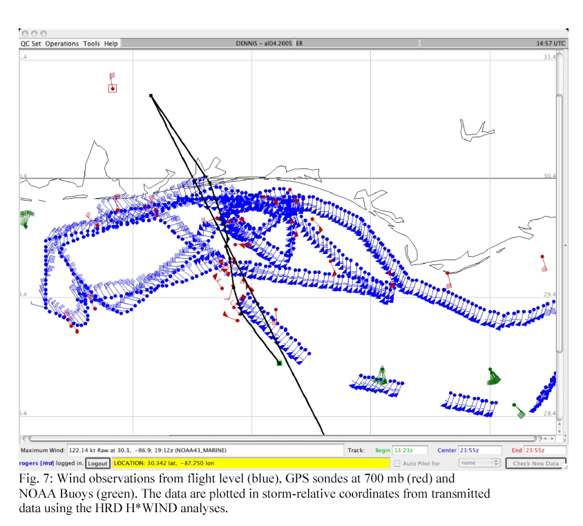
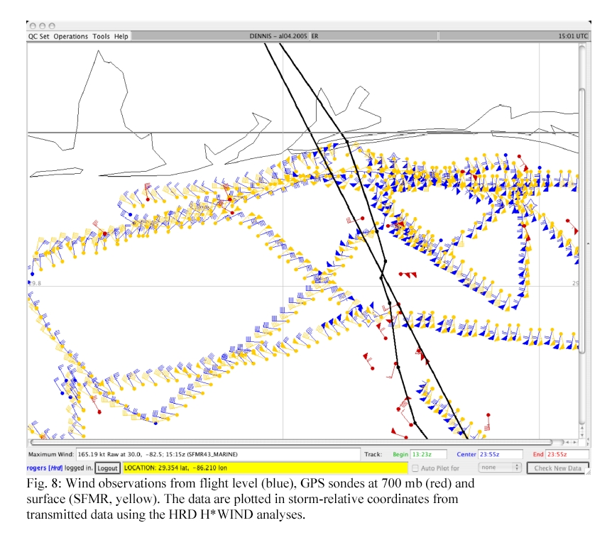
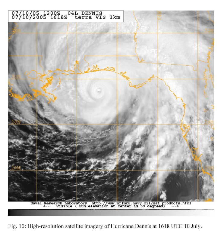
Leaving the buoy, NOAA43 continued NW and was in the eye at 1627 UTC. The eye
was small (~ 10 nmi across) and filled mostly with cloud up to our
flight-level of 12,000 ft. We continued toward the NW toward Louisiana and
through the NW eyewall where the plane encountered a large, strong
downdraft and a heavy graupel shower. Flight level winds were 120 kts in
the SE eyewall and about 105 kt in the NW quadrant. NOAA43 flew over Buoys
42007and 42040 at 1637 and 1657 UTC, respectively, releasing GPS sondes
over them. From there, we headed east back to the eye at 1720 UTC. The western
portion of the storm had unusual wind structure with GPS sondes and the SFMR
reporting surface winds of 50-60 kts while the flight-levels winds were
only about 35 kt in the offshore flow.
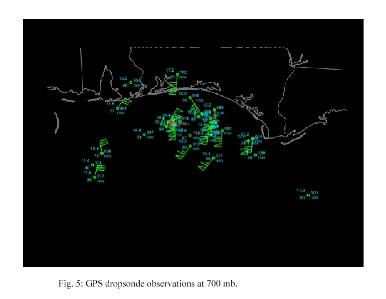
In the east eyewall, maximum surface winds from a sonde measurement and
from the SFMR were about 105 kts while maximum flight-level winds were 120
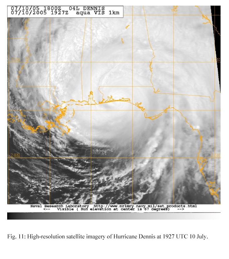
kts. A coastal run, starting about 20 miles offshore from near St. Marks,
Florida and heading to the west just north of the eyewall and ending up NW
of the center was performed from 1737 to 1809 UTC. Several GPs dropsondes
were released at the approximate locations along the coast of the portable
wind towers during this time.
N43 headed south for a short distance before entering the eye again from
the SW at 1833 UTC. From the eye, we exited to the SE to set up a run
perpendicular to the coast to drop 4 regularly spaced sondes in the high
winds just outside the east eyewall. This perpendicular leg was from 1842
to 1847 UTC. At the coast, we turned SW through the NE eyewall and into
the eye again at 1854 UTC.
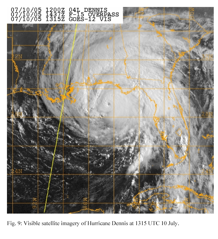
Our final coastal run was performed about 5 miles off of the shoreline
very near the time the northern eyewall of Dennis was making landfall.
Part of this coastal run was from east to west through the northern
eyewall when N43 entered the eye a final time at 1914 UTC. The aircraft
exited out to the SE and headed NE adjacent to the eyewall which was
making landfall. At 1933 the plane headed east about 5 miles offshore and
at 2000 UTC we ended out coastal run about 80 miles east of the center of
landfalling Dennis and headed back to Jacksonville where we landed about
2100 UTC.
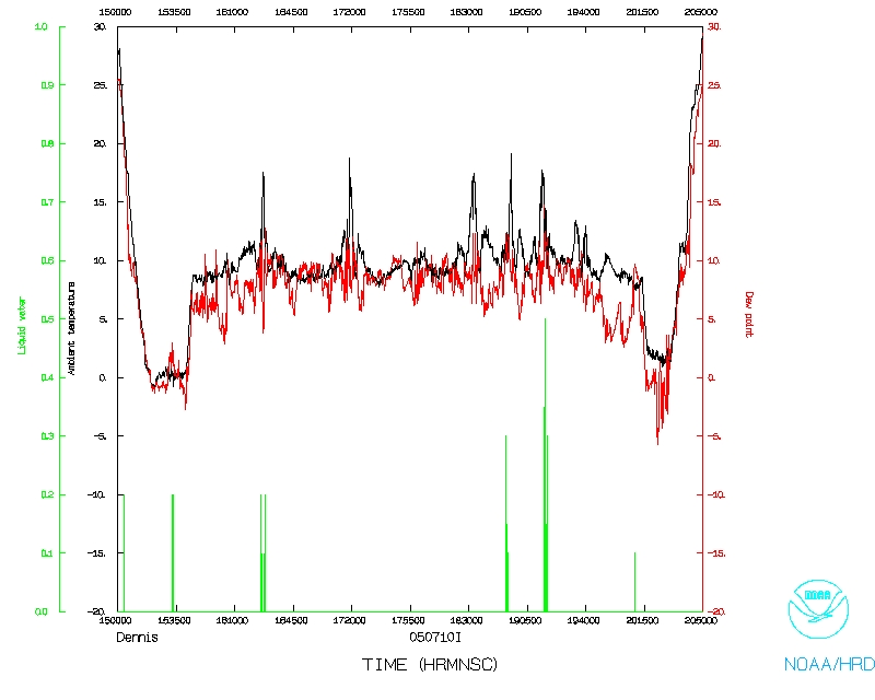
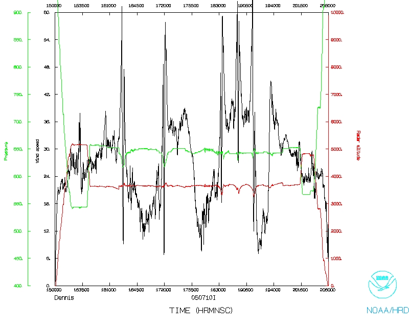
Problems :
A few of the sondes did not have launch detects (no data) and several more had
intermittent winds. The radars system had to be reset once at 1705 UTC,
resulting in a loss of data for a few minutes. The main data system worked
well.
Michael Black
7/9/05
Mission Data :
PDF plots of drop data |
One second listing |
NetCDF file
Page last updated February 15, 2006
Return to Mission page.