| Peter Dodge | Lead Scientist |
| Rob Rogers | Lead Scientist |
| Paul Leighton | Workstation |
| Shirley Murillo | Dropsonde |
| Pilots | CAPT Phil Kennedy CDR Barry Choi LT Mike Silah |
| Flight Director | Paul Flaherty |
| Navigator | LT Tim Gallagher |
| Flight Engineers | Steve Wade Joe Klipel |
| Electronics | Sean McMillan Mark Rogers ?? |
The NOAA N42RF will fly a post-landfall mission into Hurricane Dennis. The P3 will leave Jacksonville, FL at 3:00 PM EDT and will recover at Jacksonville NAS, FL at 10:00 PM EDT. During the conference call on 9 July 2005 to plan the landfall mission for NOAA 43, John Kaplan and Pete Black made the case for a second overland post-landfall flight. John Kaplan and Mark DeMaria have an ongoing research project to refine their inland decay mode and airborne Doppler data collected overland could provide a detailed verification data setl. Hurricane Dennis was forecast to make landfall near Pensacola as at least a strong Category 3 hurricane. Teams from Texas Tech University and the Florida Coastal Monitoring Program had deployed several portable wind towers on the east side of the expected landfall point, near where Hurricane Ivan made landfall last year. After some vigorous discussion...and consultation with AOC... NOAA 42 was put on the hook for a 1-3 pm EDT takeoff. 43 would take off at 11 am, so overlapping flights would give continuous coverage of the storm with sondes, airborne Doppler radar and SFMR surface winds, because we would be flying over land the altitude was set at 14,000'.
Mission Summary :
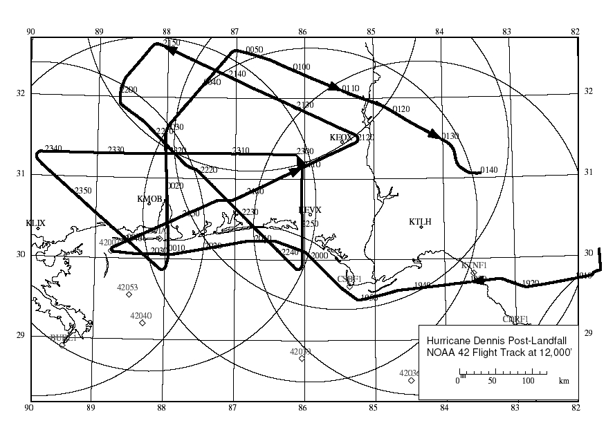
NOAA 42 took off from Jacksonville Naval Air Station at 1853 UTC, 10 July. We reached our IP, just off Cape San Blas, at 1950 and made a run along the coast to Dauphin Island. The flight track is shown in Figure 1. We dropped sondes near the FCMP and TTU tower positions as we passed by. We noted that in the offshore flow the SFMR winds were 45 kts or more while flight level winds, albeit at 14,000', were only 22 kts or so. At 2027 we dropped a sonde to verify this and the surface winds matched the SFMR. It will be interesting to examine the sonde and radar data in more detail to explain this.
The eye was already over land so to save time we turned right at 2036 and tracked 65 deg through the center. We finally saw hurricane force winds in the NE eyewall, where the maximum flight level winds were 78 kts. This pass was followed by a long L shaped track to get us to the Northwest of the storm.
Note that our northerly legs took us right over the KEVX and KMOB radars, which should provide excellent dual Doppler analyses in the onshore and offshore portions of Dennis.
After completing two more passes through the storm, at 0050 we turned to the southeast and headed back to Jacksonville. The aircraft landed back at JAX NAS at 0215 UTC.
Evaluation :
The two flights in Hurricane Dennis presented a rare opportunity to study the decay of a strong hurricane as it moved inland. Doppler data should provide both 3 d wind fields as well as vertical profiles of the wind both offshore and overland. Contributions to the evaluation of SFMR winds near the coast will come from comparing the sonde data, especially in the offshore flow where SFMR winds were 20 kts greater than the flight level winds. Our data will also provide a background context for the tower teams to interpret their detailed time series of wind speed.
Acknowledgments :
Although this pattern was not as complicated as some landfall flight patterns, the flight still required the flexibility and attention to detail that Capt. Kennedy, Paul Flaherty and the rest of the AOC flight and scientific crew provided. This flight was added on at the last moment and we appreciate AOC for once more allowing us to collect data in a hurricane at landfall. Thanks also to John Kaplan and Mark Powell for providing the FCMP tower positions and guidance in flight planning, Pete Black for planting the seeds, and Sim Aberson and Steve Feuer for ground support.
Expendables:
We used 17 GPS sondes, 6 of which failed. We also used 2 DAT tapes (radar, workstation archive) and 4 video tapes.
Problems :
The sonde failure rate was disappointing, evidently the result of a bad batch with launch detect pins that were installed too tightly. AOC is now checking all sondes for this problem. The radar system was down during our last pass through the center. The data display went down, but the data system itself remained up through the flight. In fact, Sean MacMillan wisely decided not to restart the system to restore the display, thus avoiding any interruption to the recorded flight data.
Peter Dodge
Lead Scientist
Mission Data :
Flight Data | ||
 Flight track |
 Temperature and Moisture |
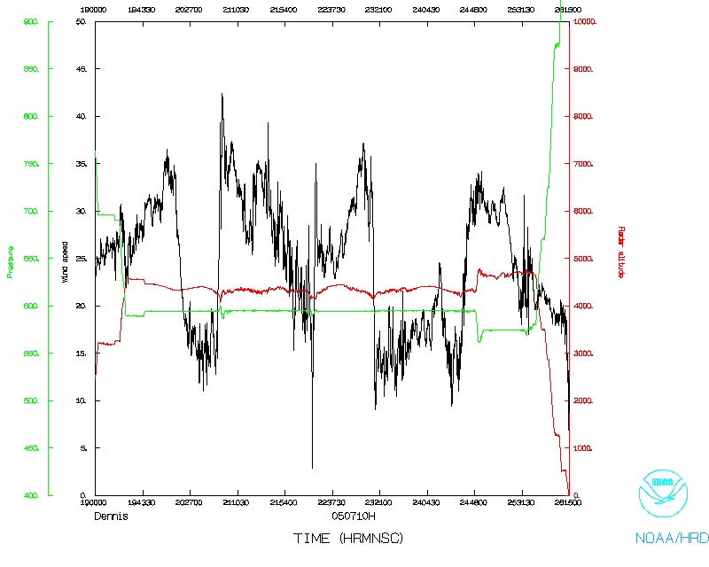 Wind and Atlitude |
| Start | End |
| 19:10:58 Z | 01:44:54 Z |