Mission Summary
20050706I1 Aircraft 43RF
IFEX/TCSP Research flight
Tropical Storm Dennis
Scientific Crew (43RF)
| Mike Black | LPS |
| Shirley Murillo | Workstation |
| Peter Dodge | Radar |
| Paul Willis | Cloud Physics |
| Robbie Hood | TCSP Scientist |
| 3 graduate students | Observers |
Aircraft Crew (43RF)
| Pilots | Randall TeBeest
Mark Nelson
|
| Flight Engineer | Dewie Floyd
|
| Navigator | Devin Brakob
|
| Flight Directors | Marty Mayeaux
Tom Shepherd
|
| Engineers | Terry Lynch
Jim Barr
Damon San Souci
|
Mission Plan :
This mission was a follow on to the flight on the day before. Here, we
wished to examine the structural changes associated with the transition of
Dennis from a TS to a hurricane. The NOAA P3 would once again coordinate
with the NASA ER2 on a modified figure 4 or butterfly pattern with 75 nmi
leg lengths at an altitude of 14,000 ft. We also had hoped to execute a
microphysical module in a stratiform region. Takeoff for the P3 was
scheduled for 1800 UTC for N43 and 1900 UTC for the ER2. Ferry time was
estimated at 2 h, 45 min, allowing for about 3 hours in the in storm
pattern, 2 h for the radial leg portion and about 1 h for the microphysics
module. We planned to drop 20 regularly spaced GPS sondes and 4 AXBTs
during the butterfly pattern.
Mission Summary :
Unfortunately the takeoff from the P3 was delayed by 4 hours due to
crewing issues and a delay on the taxiway due to air traffic. The ER2
could not delay its takeoff because of concerns of limited visibility
forecast for a later landing at San Jose. The mission plan was redesigned
before takeoff and once again in-flight to accommodate the limited amount
of time for a coordinated portion of the mission with the P3 and the ER2.
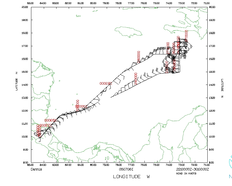
Takeoff from San Jose was at 2156 UTC and NOAA43 headed NE for the Initial
Point (IP) 75 nmi west of the projected center of Dennis. Here, we planned
a south-north pass through the eye of Dennis. The IP was reached at 0041
UTC (07/07) after a descent from the ferry altitude to 14,000 ft. The AOC
navigator communicated directly with the ER2 to coordinate the pass from
south to north across the center of Dennis. The radar signature of Dennis
during the approach to Dennis was well-defined and we adjusted our track
based on the center that was estimated from the LF radar display. The ER2
adjusted its track as well.
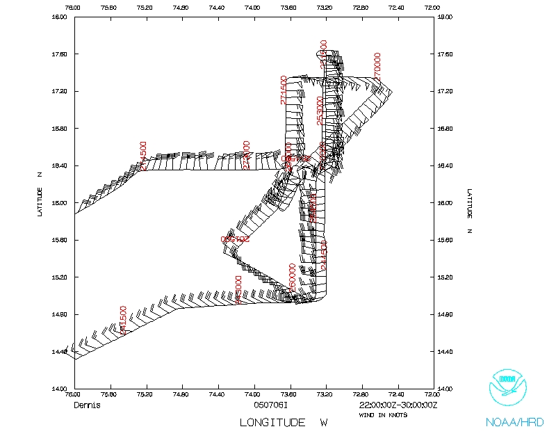
 During the northward leg into the eye, the P3 executed a slow climb
to18,000 ft followed by a slow descent back to 14,000 ft. The
ascent/descent occurred while crossing an extensive region of stratiform
rainbands and rain shield with occasional areas of modest convection. The
ER2 was well coordinated above the P3 during this maneuver. The eye was
reached at 0100 UTC where a sonde measured a surface pressure of 980 mb.
Maximum flight-level winds were about 55 kt on the south side at a radius
of about 15 nmi from the center. The eye and developing eyewall was more
clearly-defined that on the flight the day before, but Dennis was clearly
still in its organizational phase during this early phase of the flight.
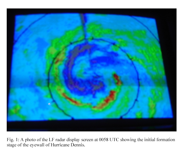
On this first pass into the eye, the eyewall was just now forming,
appearing as a large rainbands that spiraled into the center from the south
to east
During the northward leg into the eye, the P3 executed a slow climb
to18,000 ft followed by a slow descent back to 14,000 ft. The
ascent/descent occurred while crossing an extensive region of stratiform
rainbands and rain shield with occasional areas of modest convection. The
ER2 was well coordinated above the P3 during this maneuver. The eye was
reached at 0100 UTC where a sonde measured a surface pressure of 980 mb.
Maximum flight-level winds were about 55 kt on the south side at a radius
of about 15 nmi from the center. The eye and developing eyewall was more
clearly-defined that on the flight the day before, but Dennis was clearly
still in its organizational phase during this early phase of the flight.
On this first pass into the eye, the eyewall was just now forming,
appearing as a large rainbands that spiraled into the center from the south
to east
The NOAA P3 exited the eye on a northward track with the ER2 aligned
vertically above. We once again performed an ascent/descent through the
melting layer into the ice region between 14 k ft and 18 k ft. Regions of
weak stratiform rainbands populated the north side of the storm, some
areas were nearly rain-free, and a small area contained only isolated
areas of moderate convective cells. Flight-level winds reached about 70 kt
about 14 miles north of the eye associated with the end of the spiral band
that was becoming the northern eyewall. Another wind maximum of about 55
kt was in a rainband about 50 nmi north of the center where we dropped an
AXBT.
 At 0117 UTC the aircraft reached the north point at 75 nmi radius, where
we had hoped to track upwind to a point 75 nmi NE of the center to perform
a NE-SW pass with the ER2. The ER2 pilot informed us that he did not have
enough time on station to accomplish that so we instead mad a north-south
reciprocal track to the eye. Another ascent/descent through and above the
melting level was executed during this leg. Flightlevel winds were 70-75
kt about 16 nmi north of the center which the aircraft reached at 0138
UTC. The pressure had dropped to 979 mb 38 minutes after the first eye pass.
The NOAA P3 continued on the southbound track to a point 75 nmi south of
the center at 0157 UTC. The final ascent/descent was performed during this
leg, but this time we climbed up to 19 kft where the temperature was -3Á
C. Maximum flight-level winds were about 60 kt at 10 nmi radius in the
developing southern eyewall. The ER2 was headed back to base by this time
and N43 proceeded to a point 75 nmi SW of the center to begin a SW-NE pass
though the center. The pass started at 0212 UTC and N43 was in the eye at
0228 UTC. Maximum flight-level winds were about 67 kt in the SW eyewall.
We missed the wind center in the eye and executed an interesting maneuver
back through the southern eyewall before turning back around to reach the
center a second time at 0241 UTC. An eye sounding revealed that the
central pressure had stopped falling temporarily and remained at 979-980
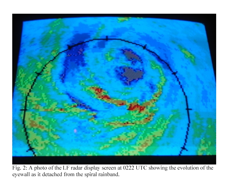
mb. The eye and eyewall continued to organize though with the eye clearing
somewhat and the eyewall becoming detached from the original spiral band
At 0117 UTC the aircraft reached the north point at 75 nmi radius, where
we had hoped to track upwind to a point 75 nmi NE of the center to perform
a NE-SW pass with the ER2. The ER2 pilot informed us that he did not have
enough time on station to accomplish that so we instead mad a north-south
reciprocal track to the eye. Another ascent/descent through and above the
melting level was executed during this leg. Flightlevel winds were 70-75
kt about 16 nmi north of the center which the aircraft reached at 0138
UTC. The pressure had dropped to 979 mb 38 minutes after the first eye pass.
The NOAA P3 continued on the southbound track to a point 75 nmi south of
the center at 0157 UTC. The final ascent/descent was performed during this
leg, but this time we climbed up to 19 kft where the temperature was -3Á
C. Maximum flight-level winds were about 60 kt at 10 nmi radius in the
developing southern eyewall. The ER2 was headed back to base by this time
and N43 proceeded to a point 75 nmi SW of the center to begin a SW-NE pass
though the center. The pass started at 0212 UTC and N43 was in the eye at
0228 UTC. Maximum flight-level winds were about 67 kt in the SW eyewall.
We missed the wind center in the eye and executed an interesting maneuver
back through the southern eyewall before turning back around to reach the
center a second time at 0241 UTC. An eye sounding revealed that the
central pressure had stopped falling temporarily and remained at 979-980
mb. The eye and eyewall continued to organize though with the eye clearing
somewhat and the eyewall becoming detached from the original spiral band
The P3 then tracked NE out of the eye and ended the 75 nmi leg at 0254 UTC.
Maximum flight-level winds in the NE eyewall were 78kt at 12nmi radius. We
had planned a downwind leg to a point NW of the center but fuel and time
constraints would not allow us to perform the downwind leg and
complimentary pass from NW to SE. Instead we tracked west to a point 65
nmi north of the center at 0312 UTC, tracked south to the center at 0324
UTC before heading outbound to the west where we ended our final leg at
0343 UTC, 75 nmi west of DennisÍs eye.
 Dennis began intensifying once again as a sonde in the eye measured a
surface pressure of 976 mb, a drop of 4mb in less than an hour. Maximum
flight-level winds were about 75 kt in the northern eyewall and 65 kt in
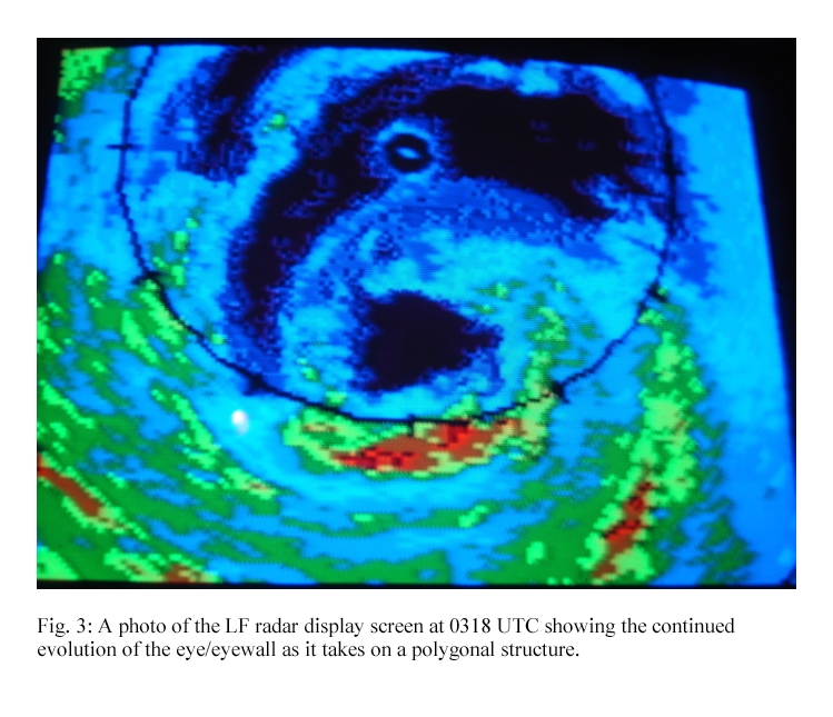
the western eyewall. The eye and eyewall were rapidly evolving as they
took on a polygonal structure during the final pass through the center
Dennis began intensifying once again as a sonde in the eye measured a
surface pressure of 976 mb, a drop of 4mb in less than an hour. Maximum
flight-level winds were about 75 kt in the northern eyewall and 65 kt in
the western eyewall. The eye and eyewall were rapidly evolving as they
took on a polygonal structure during the final pass through the center
 The ferry back took about 2.3 h and the P3 landed at 0600 UTC after
passing through another fog bank at the end of the runway. Although the
mission could not be executed as planned, valuable Doppler radar and cloud
vphysics measurements were made in a rapidly evolving and organizing
hurricane. The combination of this data combined with the concurrent
remotely-sensed instruments on the ER2, especially on the ascent/descent
areas will provide valuable information that addresses both IFEX and TCSP
goals. The flight was performed without any major equipment failures. The
coordination between the NOAA P3 and the NASA ER2 was again excellent.
The ferry back took about 2.3 h and the P3 landed at 0600 UTC after
passing through another fog bank at the end of the runway. Although the
mission could not be executed as planned, valuable Doppler radar and cloud
vphysics measurements were made in a rapidly evolving and organizing
hurricane. The combination of this data combined with the concurrent
remotely-sensed instruments on the ER2, especially on the ascent/descent
areas will provide valuable information that addresses both IFEX and TCSP
goals. The flight was performed without any major equipment failures. The
coordination between the NOAA P3 and the NASA ER2 was again excellent.
A total of 20 dropsondes were deployed during the flight and all of those were
transmitted from the aircraft. Four AXBTs were also released as planned.
The radar systems and cloud physics probes worked exceptionally well.
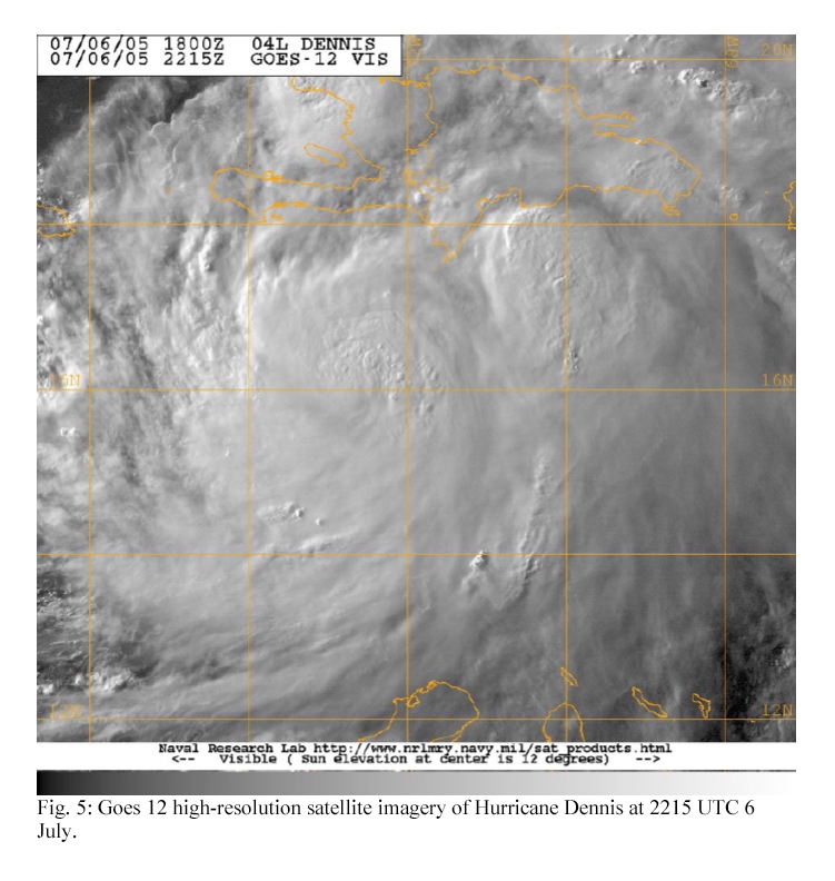
A satellite overview from the SSMI 85 GHz channel is shown in Fig. 4 and
one from the GOEs-12 visible channel is in Fig. 5.
Problems :
The HRD workstation was not operable at the beginning of the flight. The
AOC technical crew was able to remove the workstation from the rack and
perform repairs on it so that it was operating normally during the
in-storm portion of the flight.
Michael Black
July 8, 2005
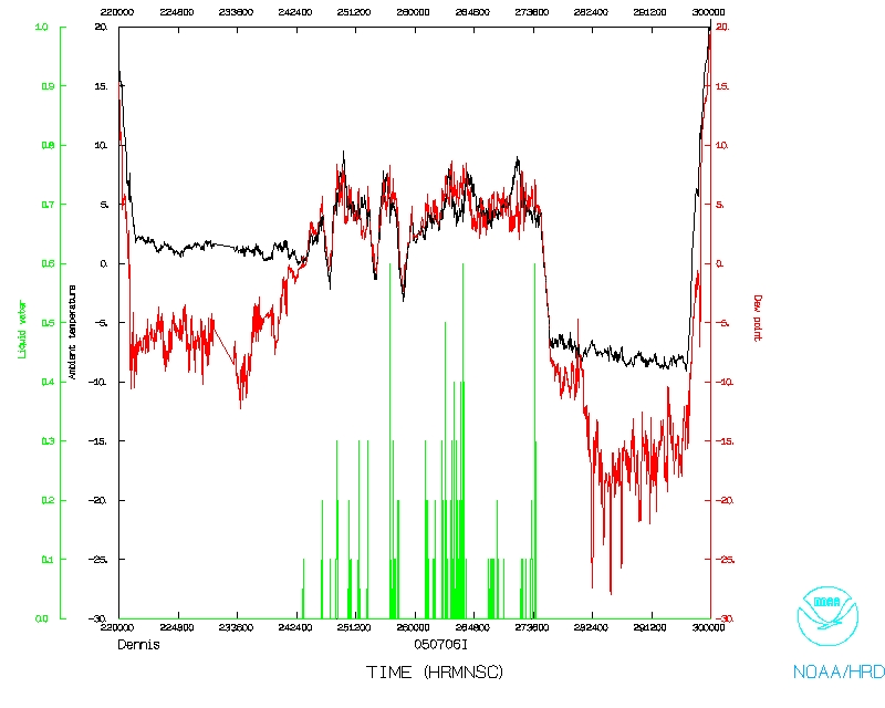
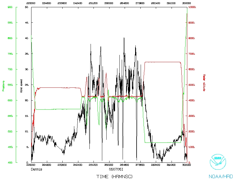
Mission Data :
Ten second listing
PDF plots of drop data
Radar coverage
| Start
| End
|
| 22:10:17 Z
| 04:15:17 Z
|
Page last updated July 11, 2005
Return to Mission page.