 The NOAA N43RF will fly a Genesis mission into Tropical Storm Dennis
in conjunction with the NASA ER2 aircraft. The P3 will leave San Jose,
Costa Rica at 1:00 PM EDT and will recover at San Jose at 9:30 PM EDT.
The NOAA N43RF will fly a Genesis mission into Tropical Storm Dennis
in conjunction with the NASA ER2 aircraft. The P3 will leave San Jose,
Costa Rica at 1:00 PM EDT and will recover at San Jose at 9:30 PM EDT.| Mike Black | LPS |
| Rob Rogers | Workstation |
| Peter Dodge | Radar |
| Paul Willis Aaron Bansamer | Cloud Physics |
| Ed Zipser | TCSP Scientist |
| Pilots | Randall TeBeest Mark Nelson |
| Flight Engineer | Dewie Floyd |
| Navigator | Devin Brakob |
| Flight Directors | Marty Mayeaux Tom Shepherd |
| Engineers | Terry Lynch Jim Barr Damon San Souci |
The NOAA N43RF will fly a Genesis mission into Tropical Storm Dennis
in conjunction with the NASA ER2 aircraft. The P3 will leave San Jose,
Costa Rica at 1:00 PM EDT and will recover at San Jose at 9:30 PM EDT.
Although the main focus of the cooperative IFEX/TCSP project with NOAA and
NASA was planned to be operating mainly in the Pacific, the rare July
formation of TS Dennis in the Eastern Caribbean provided an opportunity to
begin a series of flights into a tropical cyclone in that basin. TD # 4 had
just been upgraded to TS Dennis the morning of the flight. This was the first
opportunity to fly the system while it was in range of our operations base in
San Jose, Costa Rica. Dennis was a minimum TS that should still be in its
 organizational phase during the mission. Since the ferry to the storm would
be about 3 hours for the P3, this would leave about 2 hours to fly within the
storm core before heading back to base. We planned a coordinated flight with
the NASA ER2, which would depart San Jose an hour after the P3 takeoff to
rendezvous 100 nmi west of the Dennis at about the same time. A figure 4 with
100 nmi radial legs was planned, entering from the west and finishing to the
south. On the radials, the ER2 would fly along the same track but offset 12
nmi to the side of the track to facilitate dual Doppler coverage between the
2 aircraft. The ER2 would fly directly overhead of N43 on the downwind leg in
the NE quadrant of Dennis. The flight altitude would be 12,000 ft RA and the
radar would be operated in the F/A scanning mode except during the downwind leg
where we would operate the Doppler radar in continuous mode for comparisons
with the verticallypointing Doppler radar on the ER2. We planned on releasing
about 20 dropsondes, spaced regularly throughout the pattern and 4 AXBTs west
and north of the center.
organizational phase during the mission. Since the ferry to the storm would
be about 3 hours for the P3, this would leave about 2 hours to fly within the
storm core before heading back to base. We planned a coordinated flight with
the NASA ER2, which would depart San Jose an hour after the P3 takeoff to
rendezvous 100 nmi west of the Dennis at about the same time. A figure 4 with
100 nmi radial legs was planned, entering from the west and finishing to the
south. On the radials, the ER2 would fly along the same track but offset 12
nmi to the side of the track to facilitate dual Doppler coverage between the
2 aircraft. The ER2 would fly directly overhead of N43 on the downwind leg in
the NE quadrant of Dennis. The flight altitude would be 12,000 ft RA and the
radar would be operated in the F/A scanning mode except during the downwind leg
where we would operate the Doppler radar in continuous mode for comparisons
with the verticallypointing Doppler radar on the ER2. We planned on releasing
about 20 dropsondes, spaced regularly throughout the pattern and 4 AXBTs west
and north of the center.
Mission Summary :
 Takeoff from San Jose was at 1701 UTC and NOAA43 headed ENE for the
Initial Point (IP) 200 nmi west of the projected center of Dennis. The IP
was reached at 2008 UTC after a descent from the ferry altitude to 12,000
ft. The AOC navigator communicated directly with the ER2 to coordinate the
pass from west to east across the center of Dennis. The radar signature
of Dennis during the approach to Dennis was poorly defined and we adjusted
our track based on winds and what we were estimating the center to be from the
LF radar display. The ER2 adjusted its track as well. We flew just inside
of a large rainband that spiraled in to the center from the south. The Er2
was flying directly over this band before we made the track change. We
dropped 2 AXBTs on the way in, one at 200 nmi radius and the other 100 nmi
out. The SST was about 28.5Á C in this region. N43 reached the
poorly-defined center at 2057 UTC where a GPS dropsonde measure a surface
pressure of 1004 mb. Maximum flight-level winds were about 37 kt at a radius of
20 nmi west of the center. Surface winds, as measured by dropsondes and
the SFMR were about 35 kt.
Takeoff from San Jose was at 1701 UTC and NOAA43 headed ENE for the
Initial Point (IP) 200 nmi west of the projected center of Dennis. The IP
was reached at 2008 UTC after a descent from the ferry altitude to 12,000
ft. The AOC navigator communicated directly with the ER2 to coordinate the
pass from west to east across the center of Dennis. The radar signature
of Dennis during the approach to Dennis was poorly defined and we adjusted
our track based on winds and what we were estimating the center to be from the
LF radar display. The ER2 adjusted its track as well. We flew just inside
of a large rainband that spiraled in to the center from the south. The Er2
was flying directly over this band before we made the track change. We
dropped 2 AXBTs on the way in, one at 200 nmi radius and the other 100 nmi
out. The SST was about 28.5Á C in this region. N43 reached the
poorly-defined center at 2057 UTC where a GPS dropsonde measure a surface
pressure of 1004 mb. Maximum flight-level winds were about 37 kt at a radius of
20 nmi west of the center. Surface winds, as measured by dropsondes and
the SFMR were about 35 kt.
 The P3 and ER2 reached the center at bout the same time and proceeded to
a point 100 nmi east of DennisÍ center. Flight-level winds were slightly
stronger here, with two 40 kt maxima, one at about 15 nmi radius
associated with a spiral band near the center, and the other near 100 nmi
radius in a large, outer rainband. Surface winds on the east side of the
storm were also about 35 kt.
The P3 and ER2 reached the center at bout the same time and proceeded to
a point 100 nmi east of DennisÍ center. Flight-level winds were slightly
stronger here, with two 40 kt maxima, one at about 15 nmi radius
associated with a spiral band near the center, and the other near 100 nmi
radius in a large, outer rainband. Surface winds on the east side of the
storm were also about 35 kt.
 The coordinated, vertically-stacked downwind leg was executed form 2123
UTC to 2148 UTC. Here, the aircraft flew in and just inside of the large
N-S oriented rainband. The north point of the figure 4 was reached at 2148
where the aircraft turned southbound for our second pass through the
center. A large region of 35-44 kt flight-level (12 kft) winds was found
between 75 and 30 nmi radius on the north side. We reached the center at 2213
UTC where the pressure was still about 1004 mb. During our final outbound
leg to the south, the aircraft measured maximum winds of only 20-25 kts in
a broad region 30-60 nmi from the storm center. We ended the 100 nmi leg
at 2232 UTC where we headed WSE back to San Jose. We landed at about 0200
UTC in a fog bank that extended down to 200 feet above the runway.
The coordinated, vertically-stacked downwind leg was executed form 2123
UTC to 2148 UTC. Here, the aircraft flew in and just inside of the large
N-S oriented rainband. The north point of the figure 4 was reached at 2148
where the aircraft turned southbound for our second pass through the
center. A large region of 35-44 kt flight-level (12 kft) winds was found
between 75 and 30 nmi radius on the north side. We reached the center at 2213
UTC where the pressure was still about 1004 mb. During our final outbound
leg to the south, the aircraft measured maximum winds of only 20-25 kts in
a broad region 30-60 nmi from the storm center. We ended the 100 nmi leg
at 2232 UTC where we headed WSE back to San Jose. We landed at about 0200
UTC in a fog bank that extended down to 200 feet above the runway.
 The mission was executed as planned without any major equipment failures. The
coordination between the NOAA P3 and the NASA ER2 was excellent and the P3
navigator and the ER2 pilot should be commended for their fine work. A
total of 17 dropsondes were deployed during the flight and 15 of those were
transmitted from the aircraft. Four AXBTs were also released as planned.
The radar systems and cloud physics probes worked exceptionally well and
both were vital to themission.
The mission was executed as planned without any major equipment failures. The
coordination between the NOAA P3 and the NASA ER2 was excellent and the P3
navigator and the ER2 pilot should be commended for their fine work. A
total of 17 dropsondes were deployed during the flight and 15 of those were
transmitted from the aircraft. Four AXBTs were also released as planned.
The radar systems and cloud physics probes worked exceptionally well and
both were vital to themission.
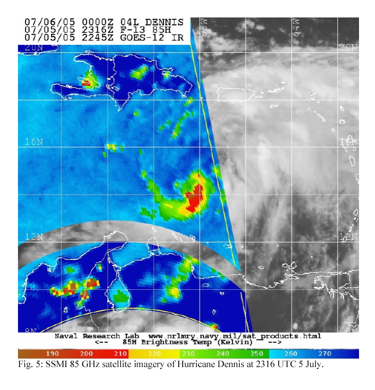
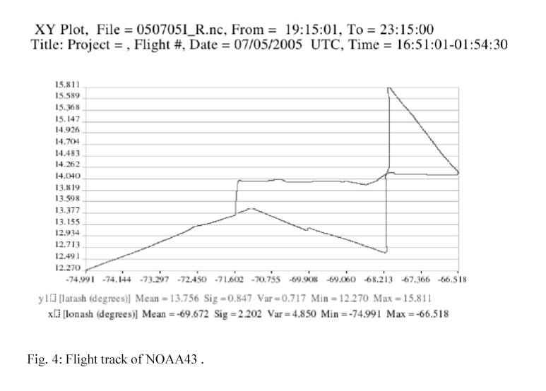
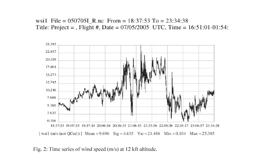
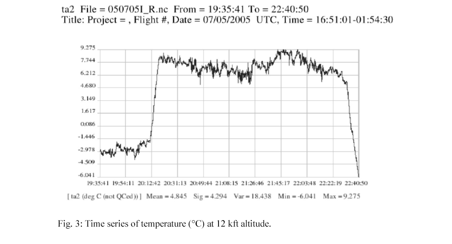
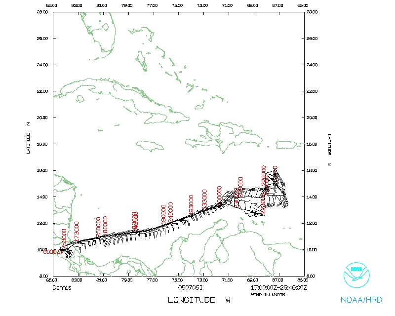
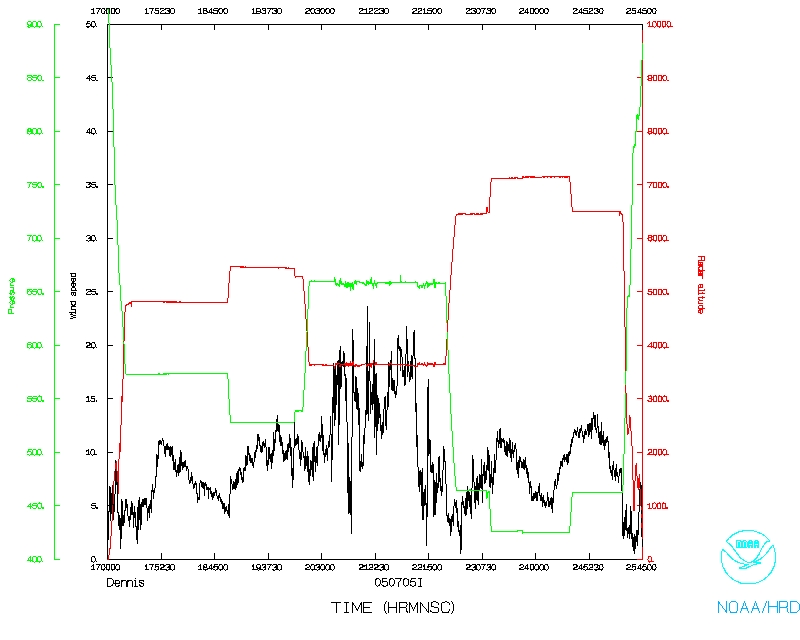
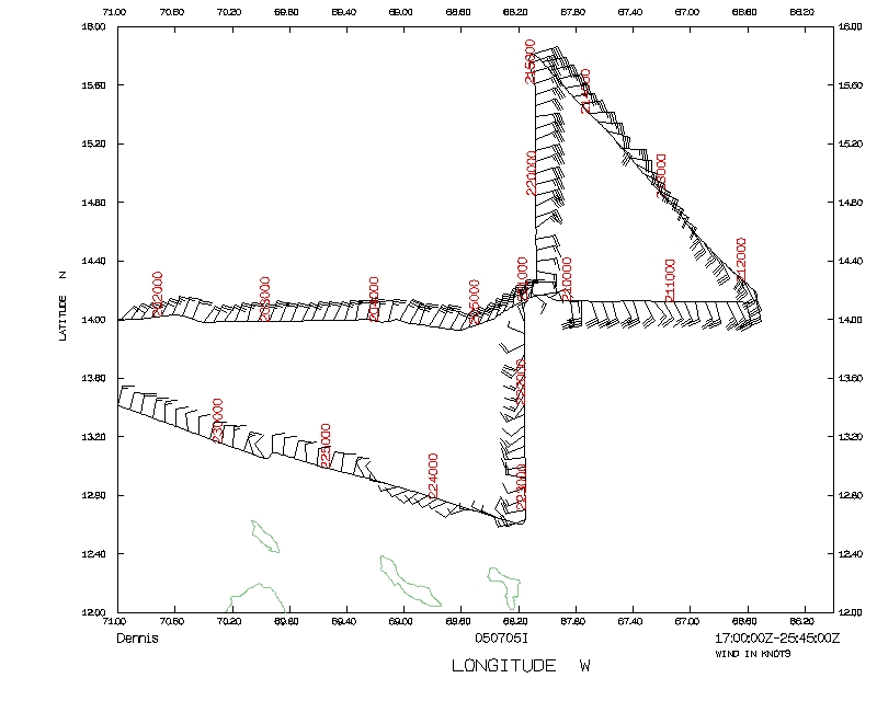
A sample of the radar imagery from the flight is shown in Fig. 1 while the wind speed and temperature trace during the in-storm portion of the flight is in Figs. 2 and 3. The track of the NOAA P3 is in Fig 4.
Problems :
There was one complete failure of a dropsonde and another that had bad
telemetry. There were also some software problems with the dropsonde
system, but this did not appear to affect the data quality. The HRD
workstation was not operable at the beginning of the flight but, after
some work, became operable for the rest of the mission.
Michael Black
7/7/05
Mission Data :
Flight Data | ||
 Flight track |
 Temperature and Moisture |
 Wind and Atlitude |
 Flight track detail |
||
| Start | End |
| 17:10:48 Z | 23:37:15 Z |