| Lead Scientist/Radar | F. Marks (C. Landsea for second half) |
| AXBT | S. Aberson |
| Dropsonde | C. Landsea |
| Workstation | P. Leighton |
| SRA | E. Walsh W. Wright (NASA/GSFC) |
| Observers | J. Lawrence (U. Houston) 2 folks from Scientific American |
On Sunday 29 August N43RF was tasked to do a single plane XCDX/Air-Sea Interaction experiment into Hurricane Dennis while it passed just E of Jacksonville, FL with a takeoff from MacDill AFB at 1730 UTC recovering back in Tampa. The plan called for 150 nm legs at 14,000 ft altitude with AXBT and GPS sonde drops on the ends of the legs, 75 nm from the center, and in the eyewall on all cardinal directions. Two drops were also planned in the eye on the first and fourth (last) passes through the center and near any buoys or CMAN sites (Table 1 1ists locations). We also hoped to collect some wave images with the SRA and to collect some stable water isotope samples. At the same time N49RF was tasked to do a synoptic surveillance mission to sample the environmental circulation surrounding Dennis with a takeoff from MacDill, AFB at 1730 UTC and recovering in Providence, RI.
Mission Synopsis :
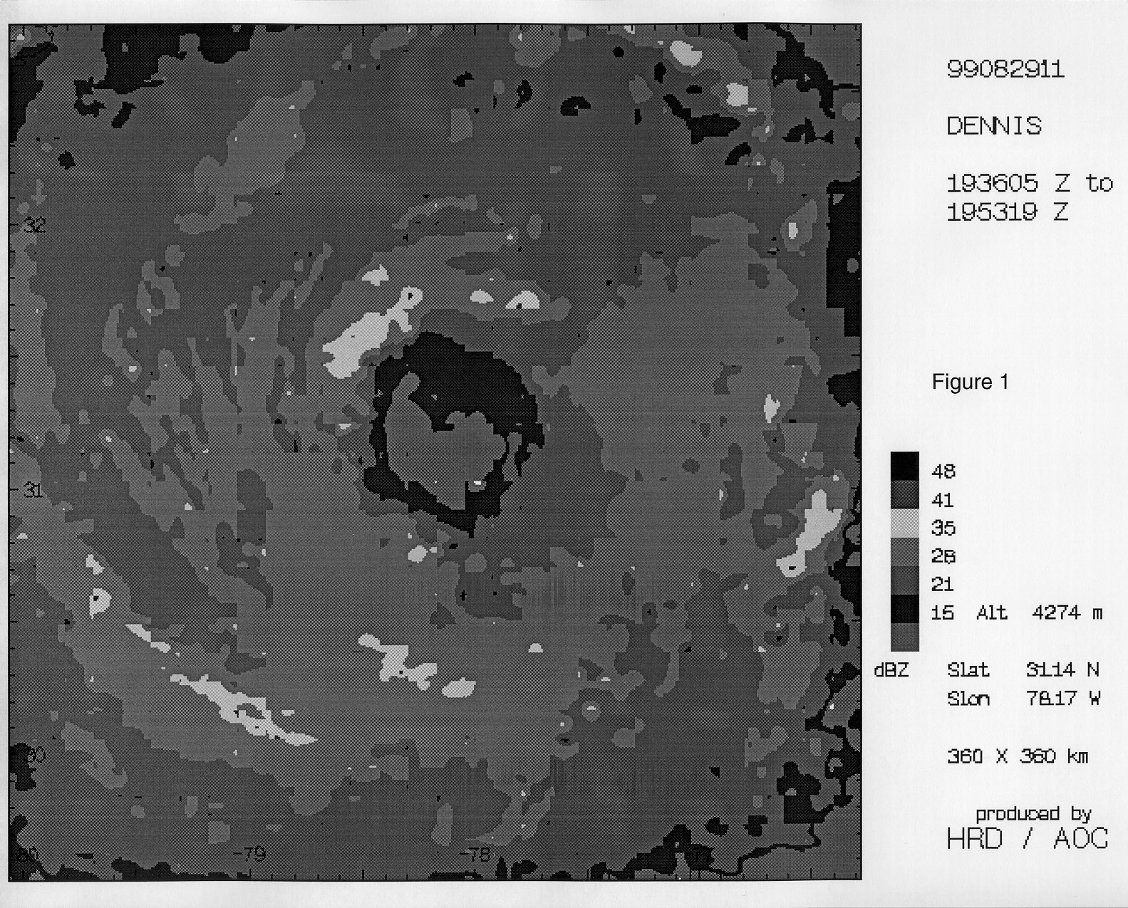
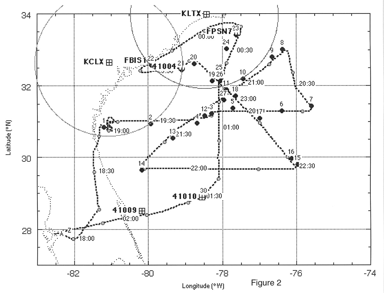
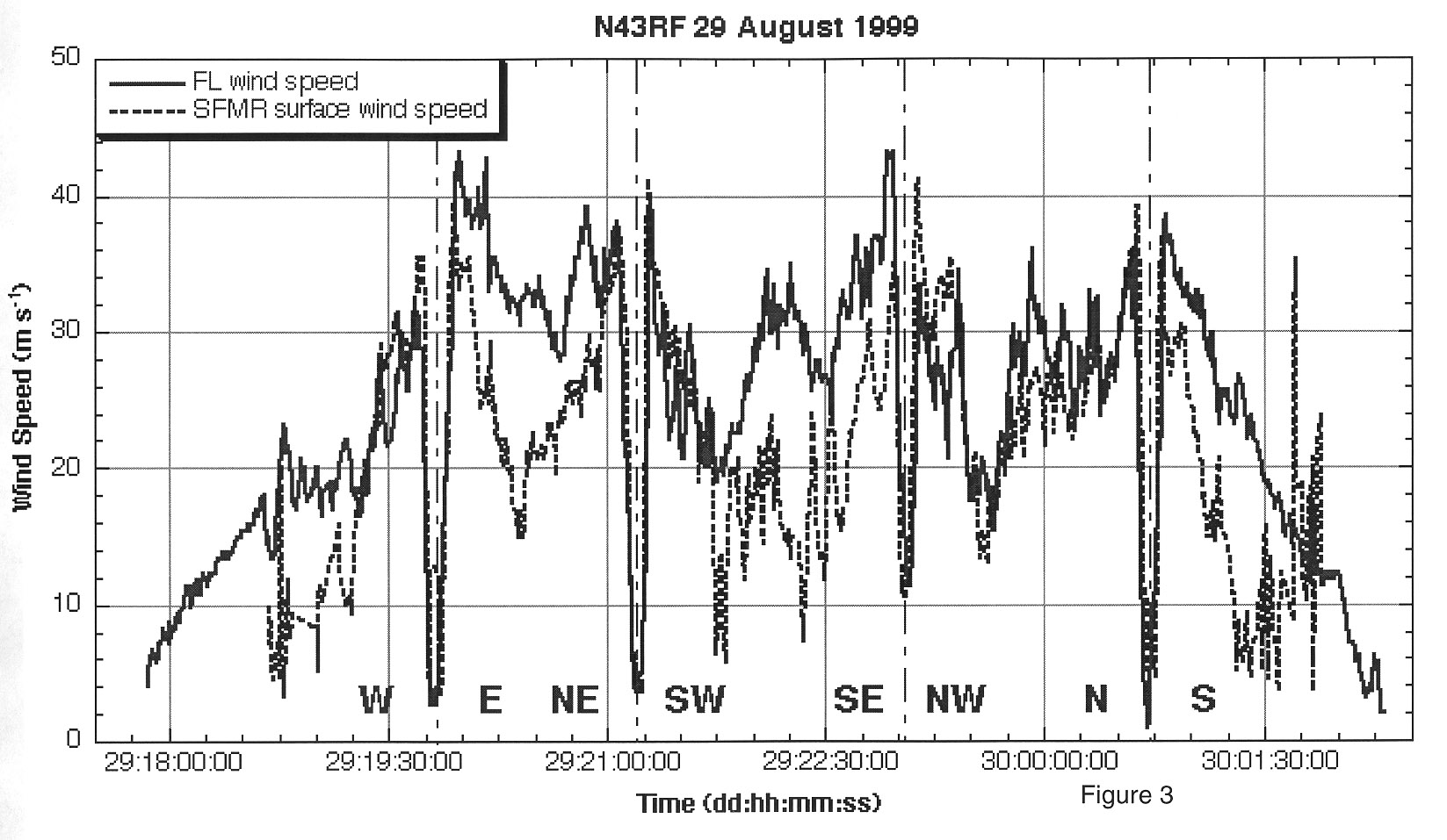
We took off from MacDill AFB at 1752 UTC and landed back at AOC 0224 UTC. After take off we proceeded to our IP roughly 150 nm W of the circulation center, just off the coast N of the FL- GA border. As we approached the IP we had some radar problems (had to swap TA transmitter) so we circled for about 10 minutes, descending to 14000 ft, and then proceeded toward the storm center starting the leg at 1916 UTC. The LF radar showed that Dennis had a ~50 nm eye and a large stratiform rain area to the NW of the center (Fig. 1). W of the center we dropped a combination GPS sonde and AXBT just inside a major rainband, 75 nm W of the center at 1928 UTC (the AXBT was bad), and then another in the W eyewall at 1943 UTC (see flight track in Fig. 2). The SFMR was working great enabling us to call the eyewall drop locations based on the trend in the surface wind estimates (Fig. 3). At the W eyewall drop location the SFMR had a surface wind of 76 kt. We passed through the center at 1949 UTC dropping a sonde with a central pressure of 967 mb (see Table 2 for center fixes and Table 3 for dropsonde splash locations). We continued tracking E dropping a sonde in the E eyewall at 1956 UTC where the SFMR had estimated surface winds >80 kt. We dropped another combo 75 nm E of the center at 2011 UTC just inside the major rainband where the SFMR estimated surface winds of 74 kt and the AXBT had a SST of 27.9°C. We dropped another AXBT 120 nm E of the center at 2016 UTC with a SST of 27.7°C. The end of the leg, 150 nm E of the center, was reached at 2021 UTC dropped a sonde and turned NNW to a point 150 nm NE of the center tracking along the major rainband.
At 2041 UTC, 150 nm NE of the center, we turned and tracked SW to the center and a point 150 nm SW of the storm. Along this leg we dropped 2 AXBTs and 3 dropsondes before we reached the center. The AXBTs showed SSTs of 28.4 -29.6°C. We reached the center at 2112 UTC, but did not drop a sonde in the center this pass. We dropped in the NE eyewall at 2106 UTC and in the SW eyewall at 2117 UTC. At 2120 UTC while we were tracking SW Pete Black called via phone patch to tell us the SFMR data was getting in and it was fantastic!! NHC was ecstatic (Jerry Jarrell said that now he could retire)! We reached 75 nm SW of the center at 2131 UTC, dropped a sonde, and then two AXBTs beyond that point to the end of the leg at 2147 UTC. At this point we tracked E to a point 150 nm SE of the center dropping a string of 6 AXBTs across the positions of the 3 mixed layer floats put out ahead of Dennis by Eric D'Asaro from University of Washington and our AXBTs from the flight the day before. Unfortunately, only 3 AXBTs worked, but they provided a cross section of the upper ocean structure across Dennis' wake where we had other complimentary data sources.
Along the S side of the storm we crossed numerous narrow intense rainbands, crossing the SE end of the major rainband just before our turn 150 nm SE of the center. After turn NW toward the center at 2230 UTC, Sim suggested we drop a sonde in the rainband to contrast with the one at the turn, which we did at 2233 UTC (drops 15 and 16 in Fig. 2). As we tracked NW toward the center we dropped 3 AXBTs and 2 dropsondes, combos 75 nm SE of the center and in the SE eyewall at 2250 and 2300 UTC, respectively. Chris pointed out that the SFMR surface winds and the flight level wind differences were asymmetric, with close agreement between the two estimates N and W of the center, while S and E of the center the flight level winds were much higher than the SFMR surface winds (Fig. 3). I pointed out that the asymmetry was likely related to the wind shear between the surface and 14000 ft, with low-level ENE flow and upper-level SW flow. We passed though the center at 2306 UTC, not dropping a sonde this pass, and proceeded tracking NW to a point 75 nm NW of the center at 2317 UTC. The plan called for us to proceed to the coast, but we turned SW to intersect the coast near the Folly Island CMAN (FBIS1) tracking over buoy 41004. We dropped sondes very close to both sitesat 2321 and 2340 UTC, respectively (drops 21 and 22 in Fig. 2).
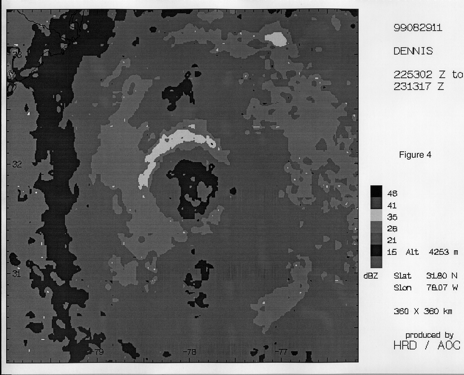
After intersecting the coast we started tracking NE upwind (Pete Black's idea) in heavy stratiform rain mapping the waves and surge along the SC and NC coast. At a point 30 nm S of Myrtle Beach we turned away from the coast around 2350 UTC and proceeded toward a point ~150 nm N of the center and the Frying Pan Shoals CMAN (FPSN7). We passed just S of KLTX at 0000 UTC in heavy ra in, reaching our farthest N point at 0019 UTC, and turned to track S toward the center. As we tracked S toward the center we passed just upwind of FPSN7 at 0023 UTC and dropped a sonde. We dropped a combo 75 nm N of the center at 0030 UTC and proceeded through some convective rainbands toward the center which showed the eye was more elliptical in shape and had shrunk to 40- 45 nm diameter (Fig. 4). We dropped a sonde in the N eyewall at 0039 UTC and then got a good fix and drop in the eye at 0042 UTC with a central pressure of 963 mb. We continued tracking S to a point 150 nm S of the center dropping sondes in the S eyewall at 0049 UTC and a combo drop 75 nm S of the center at 0100 UTC (this sonde and a backup failed to give winds). We reached the 150 nm S point at 0123 UTC and then started climbing to head home. I added a drop over buoy 41010 at 0130 UTC as we were passing very close to it in our transit back to MacDill AFB.
Accomplishments :
A great mission!! A dehmite landmark for HRD (Pete Black in particular) as we provided the first successful transmission and use of the SFMR surface winds at NHC. Not only did the data make it to the hurricane specialists (a major field program objective), but it was used in the HRD surface wind analyses for the first time. Dennis was a slowly intensifying category 2 hurricane (almost category 3) with a ~50 nm eye and a large stratiform rain area to the NW of the center. We observed peak mean boundary layer (MBL) winds of 95 kt and surface winds from GPS sondes of 90 kt. Near the end of the flight the central pressure was 963 mb.
We dropped 30 GPS sondes, 28 of which were processed and sent via ASDL. One sonde had no launch detect and the other no winds. Several others had late launch detects or no winds. We dropped 8 sondes in eyewall situations where we had good comparisons with the SFMR surface wind estimates. Also we dropped a number of sondes close to buoys (41004, 41010) and CMAN sites (FBIS1, FPSN7). We also dropped 21 AXBTs, 15 of which worked providing SST and mixed layer depth (MLD) estimates. The AXBTs provided a nice cross section of the instorm and post-storm upper ocean thermal structure close to the E edge of the Gulf Stream. We transmitted 4 LF radar composites, but no EVTD analyses (eye was too large for a solution).
Penetrations: 4
GPS sondes: 30, 2 failed
AXBTs: 21, 6 failed
Problems:
No significant scientific problems were encountered. GPS sondes that failed to provide winds were quickly replaced. All but two of the sondes were processed and transmitted for use in the models.
Acknowledgments:
Thanks to Peter and Mike Black for help with pre-mission planning. Special thanks to the crew of N43RF for their hard work ankd dedication during the flight.
Frank Marks (with input from C. Landsea)
9/20/99
Return to Dennis mission listing.
Return to Dennis main page.