Mission Summary
20090826N1 Aircraft 49RF
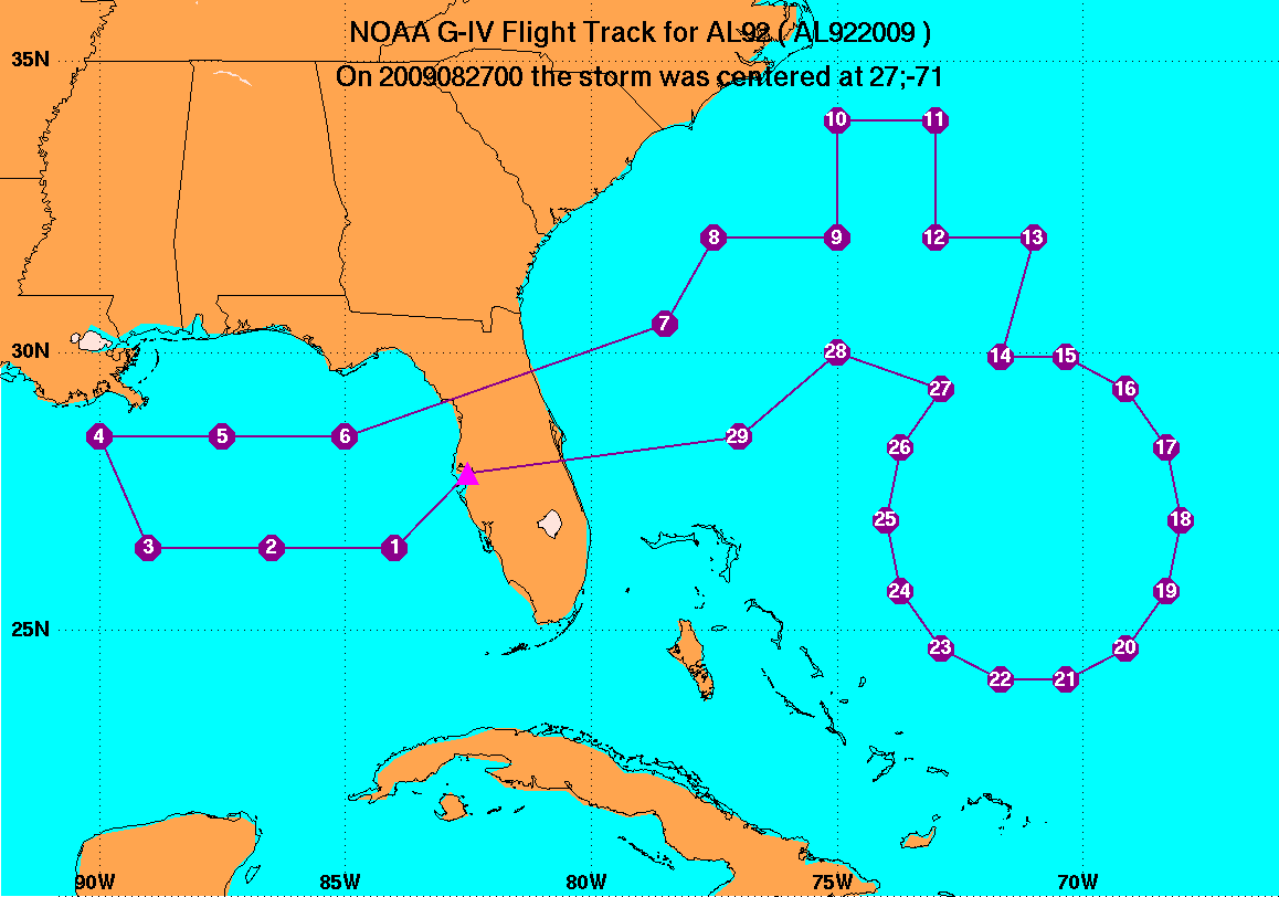
Synoptic surveillance flight about Tropical Storm Danny, 2009
Aircraft Crew (49RF)
| Aircraft Commander | Jeff Hagen |
| Co-pilot | Will Odell |
| Flight Engineer | Angel Negron |
| Flight Director | Nancy Ash |
| Flight Director | Jackie Almeida |
| Dropsonde Operator | Leonard Miller |
| Dropsonde Operator | Steven Paul |
| Dropsonde Operator | Mark Rogers |
| Dropsonde Operator | Jim Roles |
Mission Plan :
The G-IV is tasked by TPC to carry out a Synoptic Surveillance mission around
Tropical Storm Danny east of Florida. The aircraft will depart MacDill
AFB, FL 17:30 UTC and arrive in MacDill AFB, FL by 01:30 UTC.
Drop Plan
TDist 92L
Prepared by the National Hurricane Center
August 25, 2009 4:08:20 PM
Aircraft: N49RF
Altitude: FL410-450
Proposed takeoff: 26/17:30Z
|
DROP
#
| LAT
(deg) (min)
| LON
(deg) (min)
| TIME
(h mm)
|
| 1 | 26 30 | -84 00 | 0:16
|
| 2 | 26 30 | -86 30 | 0:35
|
| 3 | 26 30 | -89 00 | 0:55
|
| 4 | 28 30 | -90 00 | 1:13
|
| 5 | 28 30 | -87 30 | 1:32
|
| 6 | 28 30 | -85 00 | 1:51
|
| 7 | 30 30 | -78 30 | 2:43
|
| 8 | 32 00 | -77 30 | 2:58
|
| 9 | 32 00 | -75 00 | 3:17
|
| 10 | 34 00 | -75 00 | 3:33
|
| 11 | 34 00 | -73 00 | 3:48
|
| 12 | 32 00 | -73 00 | 4:04
|
| 13 | 32 00 | -71 00 | 4:19
|
| 14 | 29 55 | -71 40 | 4:37
|
| 15 | 29 55 | -70 20 | 4:47
|
| 16 | 29 21 | -69 08 | 4:57
|
| 17 | 28 18 | -68 18 | 5:08
|
| 18 | 27 00 | -68 00 | 5:19
|
| 19 | 25 42 | -68 18 | 5:30
|
| 20 | 24 39 | -69 08 | 5:41
|
| 21 | 24 05 | -70 20 | 5:51
|
| 22 | 24 05 | -71 40 | 6:02
|
| 23 | 24 39 | -72 52 | 6:12
|
| 24 | 25 42 | -73 42 | 6:23
|
| 25 | 27 00 | -74 00 | 6:34
|
| 26 | 28 18 | -73 42 | 6:45
|
| 27 | 29 21 | -72 52 | 6:55
|
| 28 | 30 00 | -75 00 | 7:12
|
| 29 | 28 30 | -77 00 | 7:32
|
Mission Summary :
Problems :
Mission Data :
Pressure height maps of dropsonde data
150mb map
200mb map
250mb map
300mb map
400mb map
500mb map
700mb map
850mb map
925mb map
1000mb map
surface map
Pressure height maps of dropsonde data
(Both I2 and N1 flights)
500mb map
700mb map
850mb map
925mb map
1000mb map
surface map
Page last updated August 25, 2009
Return to Mission page.
