Mission Summary
20090825N1 Aircraft 49RF
Genesis/SALEX Mission around Trop. Dist. 92L (pre-Danny)2009
Aircraft Crew (49RF)
| Aircraft Commander | Jeff Hagen |
| Co-pilot | Will Odell |
| Flight Engineer | Angel Negron |
| Flight Director | Nancy Ash |
| Flight Director | Jackie Almeida |
| Electronics Technician | Mark Rogers |
| Dropsonde Operator | Leonard Miller |
| Dropsonde Operator | Steven Paul |
| Dropsonde Operator | Jim Roles |
Scientific Crew (49RF)
| Lead Scientist | Jason Dunion (via XCHAT) |
Mission Plan :
NOAA 49RF will fly a combination Genesis Experiment and Saharan Air Layer
Experiment (SALEX) around AL92 (Pre-Tropical Storm Danny). The G-IV will leave
MacDill at 2000 UTC and will recover back at MacDill by 0430 UTC. The flight
track will take the G-IV on a clockwise circumnavigation of the storm and is
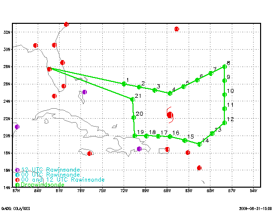
shown in Fig. 1, along with the 21 GPS dropsonde points.
|
|
Fig. 1: Flight track (white line) for Genesis/SALEX mission 20090825N1 overlaid
on GOES visible imagery from 2015 UTC. The GPS dropsonde points (21 total) are
indicated by white circles and hash marks.
|
Drop Plan
TDist 92L
Prepared by the Hurricane Research Division
File: current1.ftk
Aircraft: N49RF
Altitude: FL410-450
Proposed takeoff: 25/20:00Z
|
DROP
#
| LAT
(deg) (min)
| LON
(deg) (min)
| TIME
(h mm)
|
| 1 | 26 00 | -72 00 | 1:28
|
| 2 | 25 38 | -69 52 | 1:44
|
| 3 | 25 16 | -67 44 | 2:00
|
| 4 | 24 54 | -65 36 | 2:16
|
| 5 | 25 36 | -63 24 | 2:33
|
| 6 | 26 18 | -61 12 | 2:50
|
| 7 | 27 00 | -59 00 | 3:07
|
| 8 | 25 28 | -59 42 | 3:21
|
| 9 | 23 56 | -60 24 | 3:34
|
| 10 | 22 24 | -61 06 | 3:48
|
| 11 | 20 42 | -61 18 | 4:02
|
| 12 | 19 00 | -61 30 | 4:16
|
| 13 | 19 27 | -63 33 | 4:32
|
| 14 | 19 54 | -65 36 | 4:48
|
| 15 | 19 56 | -67 54 | 5:06
|
| 16 | 19 58 | -70 12 | 5:24
|
| 17 | 20 00 | -72 30 | 5:41
|
| 18 | 21 12 | -71 03 | 5:56
|
| 19 | 22 24 | -69 36 | 6:11
|
| 20 | 24 12 | -70 48 | 6:28
|
| 21 | 26 00 | -72 00 | 6:45
|
Mission Summary :
a) Synoptic Situation
|
|
|
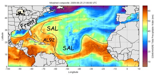
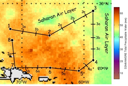
Fig. 2: (Top) TPW imagery (25 Aug 2100 UTC) showing AL92 and a large SAL
outbreak (green to blue shading; ≤45 mm TPW) located east and north of the
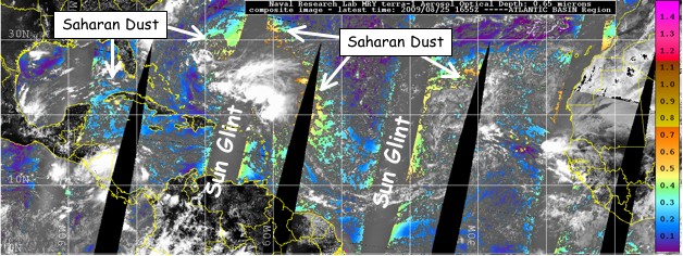
storm. (Bottom) Mosaic of aerosol optical depth from MODIS on the Terra and
Aqua satellites (valid for 25 Aug 1655 UTC) confirming substantial amounts of
dust just east and north of AL92. Images courtesy of NRL-Monterey.
|
The AEW that formed AL92 moved off the African coast on 19 August. On 26
August 0000 UTC, AL92 was associated with a broad, ill-defined circulation
centered near ~24.5oN 64oW (Fig. 2) and was positioned on the southwest side
of a large Saharan Air Layer (SAL) outbreak. Figure 2 (bottom) also shows
that the SAL air mass was located on the east, north and possibly even west
sides of AL92 was associated with aerosol optical depth values ranging from
0.2-0.7. The storm was tracking to the WNW at ~15 kt around the SW periphery
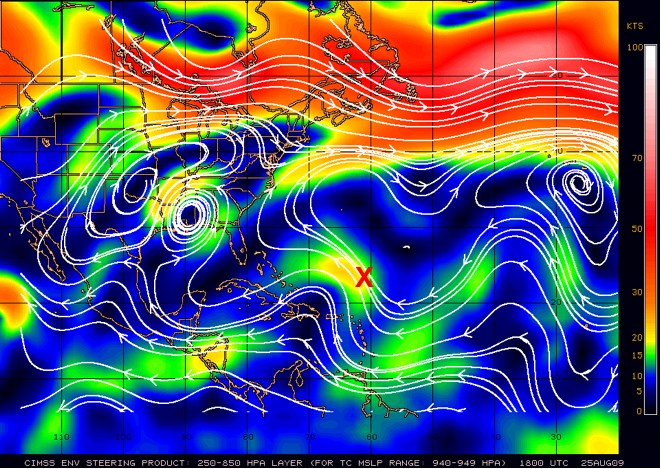
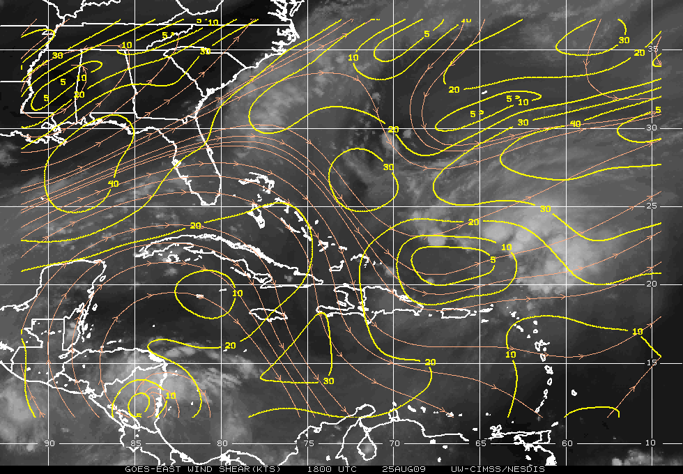
of a deep layer ridge [Fig. 3 (left)]. At this time, AL92 was located in a
region of 10-30 kt of WSW vertical wind shear with significant SW-NE oriented
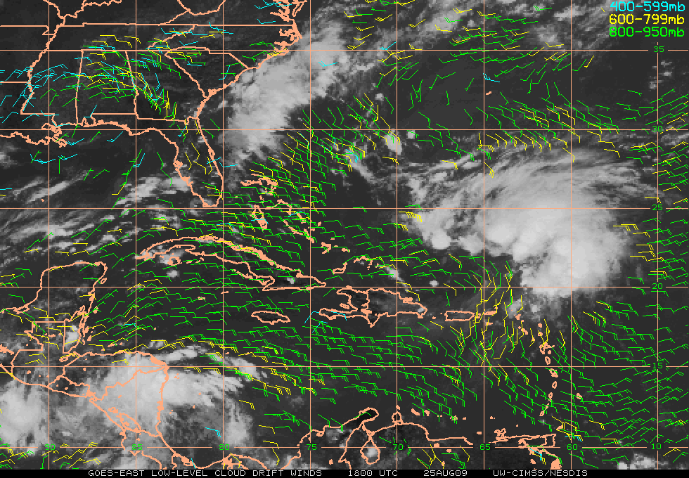
gradients (Fig. 3, right). GOES low-level cloud drift winds indicated moderate
(10-15 kt) low-level easterly flow SE of AL92 and showed that an upper-level
cold low SW of the storm was deep enough to produce a cyclonic signature in the
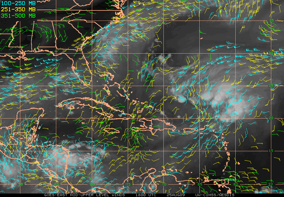
600-950 mb wind field (Fig. 4, left). GOES water vapor winds confirmed that
most of the upper-level outflow associated wit AL92's convection was
generally oriented SW to NE and was being restricted to the southwest by the
upper-level cold low. This cold low was continuing to progress to the SW away
from the storm and eventually moved into the central Caribbean. GPS dropsondes
launched from the G-IV in and around the cold low detected mid to upper-level
dry air, possibly associated with subsidence from this feature (Fig. 4, right).
TPW imagery was suggesting that dry SAL air was positioned around the eastern,
northern, and possibly western semicircles of AL92 (Figs. 2 & 6). During the
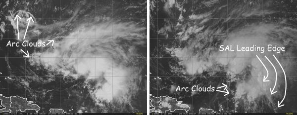
day on 25 August, arc clouds were also seen pushing out from AL92's convection
on the NW and south sides of the storm (Fig. 5). This suggested that low to
mid-level dry SAL air had penetrated these areas of the deep convection and
were likely disrupting AL92's development. Figure 5 (right) also indicates
convective enhancement along the leading edge of the SAL in the SE region of
the storm. This cloud pattern suggests that dry SAL air had also penetrated
under the cirrus canopy and reached some of the deep convection on the east
side of AL92.
|
|
|
Fig. 3: Plots of (left) 250-850 mb deep layer mean steering [magnitude
(direction) of the steering flow is indicated by colored shading (white
streamlines and the red "X" marks the approximately broad circulation center
of AL92] and (right) vertical wind shear for 25 August 1800 UTC. Images
courtesy of UW-CIMSS.
|
|
|
|
Fig. 4: Plots of (left) GOES low to mid-level cloud drift winds and (right)
mid to upper-level water vapor winds for 25 August 1800 UTC. Images courtesy
of UW-CIMSS.
|
|
|
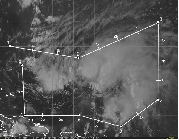
Fig. 5: GOES visible imagery on 25 August showing (left) several arc cloud
events on the NW side of AL92 at 1515 UTC and (right) an arc cloud on the south
side of the storm and convective enhancement along the leading edge of the SAL
southeast of the storm at 1915 UTC.
|
b) Mission Specifics
The flight plan was designed to investigate AL92 with targeted sampling of a
SAL air mass positioned east, north and possibly west of the storm and the
moist tropical environment associated with the storm (Figs. 2 & 6). TPW values
of ≤45 mm (>45 mm) were used to discern the SAL (moist tropical)
environments around the storm. The G-IV pattern that was flown was adjusted
just prior to take-off due to the presence of deep convection that was
concentrated east of the "center". Drop points 3-4a were originally designed
to sample closer to the "center" but were shifted east to avoid the convective
cloud tops that were well above the G-IV flight level.
Takeoff was at 2000 UTC from MacDill. The flight plan called for a clockwise
sampling of the storm at an optimal flight level of 41,000-45,000 ft. Main
targets included the SAL air mass around the eastern, northern and western
semicircles of the storm, the moist tropical atmosphere close to the "inner
core" region and the transitional environment between the SAL and the "inner
core" environments.
Dropsondes launched around the northern semicircle of AL92 (drops 1b-3)
indicated that dry SAL air with collocated 42-64 kt easterly jets had
penetrated quite close to the deep convection in this area of the storm. The
base of the SAL in this area exhibited 2-3oC temperature inversions and there
were also indications that some of this dry air may have been advected well
below the SAL base (~near-surface to 850 mb). The arc clouds (and associated
convectively driven downdrafts) that were noted in the satellite imagery (Fig.
5) may have been responsible for this drying in the lower levels. Drops 3-4
sampled the presence of a classic ~500-850 mb SAL east of the storm. Drops
4-5 indicated that dry SAL air was collocated with 28-32 kt southeasterly jets
and that the SAL had indeed penetrated from the east to the edges of the deep
convection in the SE quadrant of the storm. Drop 6b showed a wedge of dry air
and NW winds from ~600-850 mb suggesting that the SAL on the northern
semicircle of AL92 (Figs. 2 and 6) had advected around the west side of the
storm down to the SW quadrant.
|
|
Fig. 6: TPW imagery showing AL92 on 25 August 2100 UTC. The SAL's dry air is
indicated by values of ≤45 mm (green to blue shading) in the TPW image. The
G-IV flight track (black curve) and dropsonde points (black circles and hash
marks) are overlaid for reference. Imagery courtesy of UW-CIMSS.
|
Problems :
There were no major problems related to this flight. Twenty-one GPS dropsondes
were deployed during the mission, five of which were "fastfalls". No HRD
scientists were onboard. Instead, coordination (e.g. track changes and drop
point changes) was handled via XCHAT. This worked fairly well, though it did
not result in optimal sampling of the storm and its environment.
Mission Data :
Pressure height maps of dropsonde data
100mb map
200mb map
250mb map
300mb map
400mb map
500mb map
700mb map
850mb map
925mb map
1000mb map
surface map
Page last updated October 14, 2009
Return to Mission page.