| Lead Scientist | P. Black |
| Radar | J. Gamache |
| Workstation | P. Leighton |
| GPS sonde scientist | C. Landsea |
| AXBT scientists | J. Cione, D. Jacob |
| Observer | D. Jacob |
Mission Briefing:
This mission was an air-sea interaction mission designed to
measure atmospheric and oceanic boundary layer structure
simultaneously with GPS sondes and AXBTs during the passage of
Danielle over the cold wake left by Hurricane Bonnie one week
earlier. Concurrent flights by the other NOAA P-3 flying an
Extended Cyclone Dynamics pattern (300 nm legs at 500 mb), NASA
DC-8 at 37 kft and the AFRES WC-130 at 10 kft were made. Leg
lengths were 100 nm.
Mission Synousis :
The flight departed Opa Locka at 1935 UTC, 30 August and landed
at Opa Locka at 0345 UTC, 31 August. A total of 30 GPS sondes
and 15 AXBTs were dropped during this mission, from 8 kft. The
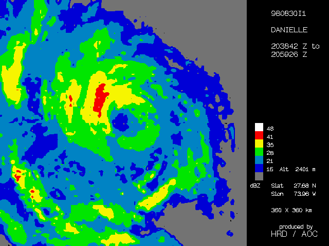
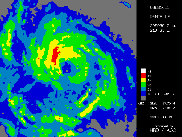
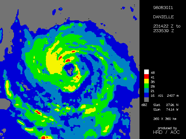
Figure 4 legs were oriented W-E, N-S, SE-NW, SW -NE and E-W. Maximum
flight-level wind in the inner core was 85 kt. Minimum central
pressure was 983 mb and the eye diameter was 25 nm, while the
outer eye/rainband diameter wa 80-90 nm. The storm was stationary.
A major feeder band consisting of several thinner bands was
observed spiraling into the inner core to form an outer eyewall
from the SE, E, through NE, N and NW. Strongest eyewall convective
bands, with cloud turrets extending to 55-60 kft (as observed by
the ER-2),were along the E sector of the inner eyewall (45 dBZ
reflectivities). The eyewall was open to the west. A strong CB
developed within the clear eye region on the south side as we
traversed from N-S, and containing the flight level wind max of 85
kt. 85 kt flight level wind maxima were also observed in the
outer band to the N, NW and W of the center. The inner E
eyewall had only 65 kt winds at flight level, but 105 kt at 925 mb.
GPS dropsonde wind profiles in the W eyewall, where convection was weak, differed dramatically from those in the E eyewall, where convection was very strong. Profiles in the W showed nearly constant 65-70 kt winds with height down to 400 m, near the top of the well- defined boundary layer. Winds decreased linearly from there to the 10-m level where winds were 45 kt. In the E, winds increased downward from 60 kt to 106 kt at 850 mb, maintaining nearly constant wind with height to 60 m, then decreasing rapidly to 70 kt at the 10-m level. In the 106 kt high wind layer, strong inflow was observed with wind direction veering inward by more than 60° between 850 mb and the surface. The convection was therefore associated with an enhanced inflow jet in the lowest levels on the E side of the storm. The strong inflow, enhanced southeasterly horizontal flow and strong convection associated with strong updrafts on the east side coupled with enhanced horizontal flow in the upper levels on the W side, some outflow in the low levels and subsidence in the W suggest the vortex was interacting with westerly or northwesterly shear (strong environmental SE low level winds, weak upper level winds). This notion is supported by hodograph plots of mean storm-domain winds computed from TA Doppler radar data.
Doppler radar showed a strong low level wind max of over 100 kt
on the east side of the center. The 500 mb center seemed to be
displaced about 12 km NE of the surface center, which could be
clearly identified by a swirl in the low clouds within the 500
mb eye.
Excellent tail Doppler and lower fuselage radar data were also
obtained (3 radar composites were
transmitted to NHC in real-time, but no EVTD wind fields were
sent). We also collected some good F/AST data along a N-S line
of convection 10 nm W of the west eyewall. Cloud microphysics
data were also collected (good ice data in the rainbands W of
the center and rain data in the inner core).
The successful AXBT launches in the S, SE and E eyewalls reported SSTs between 27.2-26.2° C, about 2-3° cooler than the 29.0° C SSTs observed 2 days ago. Estimates of ocean mixed layer depth in this region ranged between 60-90 m in this area, about 20-30 m deeper than 2 days ago, suggesting that strong mixing had occurred beneath the storm in the 12-18 hrs that it had remained stationary. This cooling under the eye and E eyewall semicircle may have been primarily responsible for the cessation of the storm deepening and decrease in convection.
Evaluation:
This flight is part of a landmark 5-plane synoptic flow experiment for determining the environmental flow structure of the atmosphere around a developing TC while also determining the oceanic thermal structure beneath the inner core. It marks the first time in history that 5 research aircraft have flown a coordinated pattern simultaneously in a hurricane.
Problems:
Difficulties were again encountered in deploying GPS sonde pairs on either side of the convective eyewall during the SW-NE transit due to a GPS receiver channel failure in the aircraft. This lead to missed drop points in the eyewall.
Peter G. Black
Return to Danielle mission listing.
Return to Danielle main page.