Click here for a PDF version
of this summary.
Mission Summary
Danielle
980829I1 Aircraft 43RF
Scientific Crew (43RF)
| Lead Project Scientist | Frank Marks
|
| Radar Scientist | Neal Dorst
|
| Cloud Physics Scientist | Chris Landsea
|
| Dropwindsonde Scientist | Sim Aberson
|
| WARDS Scientist | Peter Hildebrand
|
| Workstation Scientist | Paul Leighton
|
Mission Briefing:
At 2000 UTC on 29 August Hurricane Danielle was projected to be
a 25.5° N and 71° W, moving WNW at 11 kts. We briefed the
N43RF crew for the Vortex Motion and Evolution Experiment (p. 19 in
HFP) with a take off at 1800 UTC from Opa Locka in Miami. The
initial point (IP) in the pattem was 160 nm SSW of the center.
Flight-level was planned to start at 18,000 ft outside 50 nm
radius from the center, climbing as high as possible throughout
the mission. Inside 50 nm radius flight level would be 16,000 ft to
avoid pstatic effecting the GPS-sonde antenna.
Mission Synopsis :
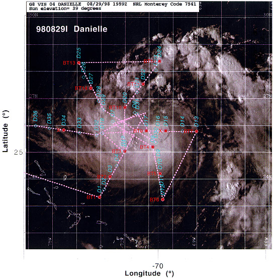
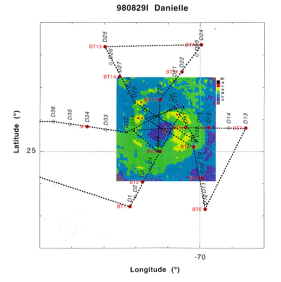
Take off occurred at 1820 UTC and we proceeded to the IP (2005
UTC). Radar revealed that Danielle was trying to form an
eyewall with a radius of 25 nm. The developing eyewall was on
the SE corner of a large hook shaped principal rainband curving
around the center from 200 nm SE of the center through 150 nm N
of the center to 50 nm NW of the center. The principal band
contained active convective cells all along its length.
Initially, the eyewall was characterized by an opening to the
NW, with a large anvil over the inner 50 nm radius. Scatterers
were confined to the convection SW, S, SE, and E of the center
at all levels and at low and high levels to the NW. During the
mission the NE comer of the developing eyewall slowly wrapped
around the center, and by the last pass through the center
convection was growing all around the center.
The first coordinated dual-Doppler pattern was from 2029-2130
UTC. N43RF ran the Doppler radar with single PRF (1600)
scanning perpendicular to the track on all of the radial legs
to produce an EVTD analysis, while N42RF ran the Doppler radar
in dual-PRF (2100/1400) and F/AST on all legs. The EVTD was
completed showing over 80 kt winds at 1 km in the NW side of
the storm and transmitted for the first time back to NHC (it
was received and given to the hurricane specialist). The center
at 1 km altitude was found WNW of the flight level center at
16,000 ft. Peak winds of 70 kts were found at flight level in
the SE quadrant. The EVTD-derived hodograph showed the storm
was embedded in a flow with a low-level (600-850 mb) E jet with
mean winds of 10 kts. The hodograph showed the winds dropped
off both above and below these levels.
The second coordinated dual-Doppler pattem was from 2252-2344
UTC. On this Fig-4 N42RF ran their Doppler radar with single
PRF (1600) scanning perpendicular to the track on all of the
radial legs to produce an EVTD analysis, while N43RF ran the
Doppler radar in dual-PRF (1600/1050) and F/AST on all legs.
N42RF ran an EVTD and successfully transmitted their first
analysis to NHC. Again the center at the surface was found WNW
of the flight-level center at 16,000 ft. Peak winds of 70 kts
were found at flight level in the SE quadrant. At the end of
the outbound leg 160 nm N of the storm the radar system crashed
taking 9 min to be restarted. Fortunately, very little
scatterers were present in this part of the pattern and no data
was lost.
The third coordinated dual-Doppler pattern was from 0105-0201
UTC. As on the last coordinated Fig-4 N42RF ran their Doppler
radar with single PRF (1600) scanning perpendicular to the
track on all of the radial legs to produce an EVTD analysis, while
N43RF ran the Doppler radar in dual-PRF (1600/1050) and F/AST
on all legs. The first leg was very well coordinated with both
planes passing through the eye at the same time (visual
confirmation), and 3-min after the AFRES WC-130 and 1 -min
after the NASA DC-8. The second leg was not as well coordinated
as N42RF cut their downwind leg short to avoid intense
convection, thereby getting to the center 5 min ahead of us.
AXBTs on the first leg showed peak SST 160 nm WSW of the
center of 28.2°, remaining above 27° through the center
to 50 nm NE of the center. The coldest SST was 25.7° 160 nm
SSE of the center in the wake of both Bonnie and Danielle. SSTs
in the precipitation within 100 nm E of the center were typically
hovering near 26-26.5°, while SSTs 160 nm N of the center were
over 28°.
We had one GPS-sonde failure out of 38 total drops on the 75
nm ring E of the center inbound to the second coordinated
Fig-4. We also had one bad AXBT at the 100 nm ring on the same
leg and another at the 100 nm ring W of the center.
We had 6 penetrations.
Evaluation :
Overall the experiment went very well as we completed the whole
pattern as planned. With the addition of the DC-8 dropsondes
from 35,000 ft in the core and the presence of the G-IV
dropsondes surrounding the storm, this experiment should provide
an unprecedented data set to match the inner vortex onto it
environment for use in studies of vortex interaction. The
presence of the DC-8 dropsonde themmodynamic data will provide
an excellent opportunity to derive the potential vorticity
structure of the vortex. The evolution of the eyewall as it
formed during the mission, combined with the missions the next
day should provide an excellent opportunity to study the vortex
evolution.
The coordination with N42RF was pretty good during the
coordinated dual-Doppler legs in the core. We typically passed
through the center within 1 min of N42RF. On the next to last
leg we passed though the eye at the same time as N42RF, 2 min
after the AFRES WC-130 and 1 min after the NASA DC-8. The worst
coordination occurred on the last leg when N42RF crossed the
eye 5 min ahead of us. The GPS sondes perfommed very well, with
only one complete sonde failure out of 38 total drops. 3-4
other dropsondes had partial failures. The radar data system
also performed well, with only one outage along the downwind
leg 160 nm N of the center, where we had no scatterers. The
AXBTs also worked real well with 13 good sondes out of 15
total.
Most of the data systems worked very well. We did have a few
problems:
- 2D-P was not working for almost the whole flight. 2D-C was very
noisy for most of the flight, but did seem to be getting some
good images.
- Radar system crashed at 0011 UTC and was down for 22 min
while we were traversing downwind 160 nm N of the storm.
However, no significant data was lost as there were few
scatterers.
- Two AXBTs failed: one had no launch signal and the second
had no data.
- One total failure of the GPS sondes (D16). 3-4 had partial
winds in the boundary layer.
Frank Marks
3 September 1998
Return to Danielle mission listing.
Return to Danielle main page.