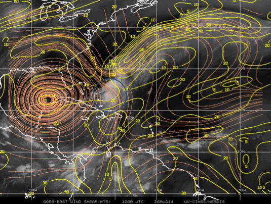
 Figure 1: Environmental shear analysis at 1200 UTC on August 26, 2014 from the Cooperative Institute for Meteorological Satellite Studies (CIMSS) product. The blue circle indicates the storm location. |
| Aircraft Commander | Harris Halverson |
| Co-pilot | Chris Kerns |
| Co-pilot | Pat Didier |
| Navigator | Tim Gallagher |
| Flight Engineer | Ken Heystek |
| Flight Engineer | Paul Darby |
| Flight Director | Rich Henning |
| System Engineer | Jim Roles |
| System Engineer | Joe Bosko |
| Data Technician | Terry Lynch |
| AVAPS | Todd Richards |
| LPS | Jun Zhang (HRD) |
| Radar | Frank Marks (HRD) |
| Sonde | Rob Rogers (HRD) |
| CCN spectra | Luke Ziemba (NASA) |
| Observer | Jonathan Vigh (NCAR) |
| Observer | Ivan Popstefanija (ProSensing) |
Mission Plan :
The goal of this mission is to conduct EMC-tasked TDR pattern in Tropical Storm Cristobal. The system was declared a hurricane 1 day earlier, although it did not resemble the cloud pattern of a typical hurricane. Before taking off, Cristobal is still a sheared storm with linear convective structure. The system is also embedded within the tail of a frontal zone. The Air Force Reserve aircraft before our mission measured flight-level winds of 73 kt supporting the initial intensity of 65 kt. The environmental vertical wind shear is moderate (~15 kt) and still stays from north to northwest (Fig. 1). The storm has a northward motion of ~10 kt and is expected to move north-northeastward. From the IR satellite image it appears that the storm is still connected with a frontal zone north and northeast of the storm (Fig. 2). It appears also that most of the convection is located on the south and south-east side of the storm center. The intensity forecast guidance suggests slowly and steadily intensify with the next 60-72 h with intensity between 65 and 80 kt.
|
Figure 1: Environmental shear analysis at 1200 UTC on August 26, 2014 from the Cooperative Institute for Meteorological Satellite Studies (CIMSS) product. The blue circle indicates the storm location. |
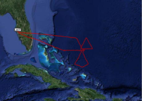
The plan calls for a butterfly TDR pattern, with an initial point on the west side (Fig. 3a). The legs will be 120 nm in length. Drop sondes at the turn, mid, and center points. 2 AXBT's will be deployed. The pattern will be flown at 10,000 ft.Take off is from MacDill AFB, FL at 18:00 UTC and recover at MacDill AFB, FL or MacDill AFB, FL by 02:00 UTC the follwing day.
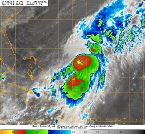 Figure 2: Infrared satellite image from GOES-13 taken between 6-12 Z on August 26, 2014. |
Mission Summary :
| Take off | Landing
| MacDill AFB, FL
| 05:47 UTC
| MacDill AFB, FL
| 13:13 UTC
| Penetrations
| 3
| | ||||
|
|
| Figure 3: (left) Planned flight track. | (right) actual flight track. |
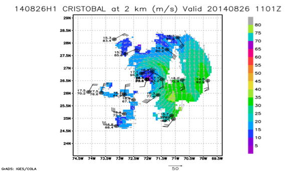
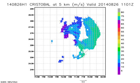
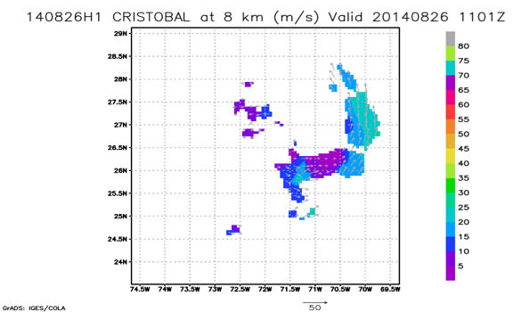
The actual flight track in shown in Fig. 3b. Takeoff was at 0547 UTC from Tampa. The winds at flight level showed a broad circulation, with peak winds of ~75 kt on the southeast side of the storm where SRMF winds of 60 kt. The center pressure remained ~984 mb during the flight. Aircraft fixes suggest that the storm motion speed is ~10 kt with motion direction of 12 degree. Real-time Doppler radar analyses (Fig. 4) showed that the circulation was displaced about 50-70 km between 2 and 5 km altitude. The wind field at 8 km shows limited data coverage indicting the vortex of Cristobal is shallow. The storm intensity remains steady (~70 kt) during the mission. The aircraft landed at Tampa at 1313 UTC. 22 sondes were launched and 2 AXBTs released, all were transmitted.
Mission Evaluation :
 |
 |
 |
|
Figure 4: Real-time Doppler radar analysis of the wind speed at 2, 5, and 8 km. Dropsonde measured wind speed and direction are also shown. |
A total of three radar analyses were created and transmitted in real time, as well as 21 dropsondes and 2 AXBTs. HD ob software went off several times during the flights. Radar analysis software was working well till the third analysis. The problem was fixed till the landing time and super-obs were sent out the plane successfully in the end. Dewpint sensor reading was wrong at the beginning of the flight and was fixed. The IR sonde and AXBT were not dropped at the highest wind region. The sea surface temperature (SST) measured by the IR sonde and AXBT match excellently well for surface wind speed of ~40 kt outside the convective region.
Problems :
The primary problem with this flight was the failure of the radar software during the third radar analysis. However, this problem was fixed at the end of the flight and the radar analysis of the last leg was successfully transmitted.
Jun Zhang
Nov. 6, 2014
Mission Data :
serial data |
Flight Director's manifest |
Flight Director's log