Mission Summary
20030821H Aircraft 42RF
inter-comparison and calibration flight
between NOAA43/NOAA 43
Scientific Crew (42RF)
'
| Lead Project Scientists
| Paul Chang
Sim Aberson
John Gamache
|
| Radar Scientist | John Gamache
|
| Flight Director | Tom Shepherd
|
Mission Briefing :
- Fly out to buoy
- Do 12-sonde (4 on 43, followed by 8 on 42) drop sequence inbound
to simulated storm center at buoy. All drops except one sonde (at
handover from 43 to 42, i.e. 42's first sonde) and one AXBT
(innermost drop i.e. 42's last inbound drop) are simulated drops.
One real sonde drop, one real AXBT drop. To simulate real flying
the leg through the center was flown from the NE to SW, instead of the
cardinal heading on N to S as on the 19th.
- Circling while simulated sondes drop to surface
- Do another 12-sonde sequence in reverse during 'outbound' leg
(8 on 42, followed by 4 on 43). Again the handover sonde (42's 8th
outbound sonde) and the innermost AXBT (42's first outbound drop
point).
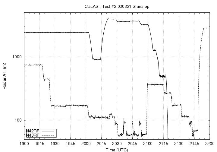
- Find spot near convection to simulate flying stairstep patterns
in hurricane 'moat' (or clear) region between eyewall and rainband.
- Fly above 43 during its first 'L' pattern in its shorter 3-level
stairstep pattern. Coordinate to stay several nm behind 42. Launch
sonobuoys at three points of 'L' pattern.
- Find clear spot for Bob Black to run his field mill calibration
at 5, 10, and 15,000 ft.
- Return to Base
Mission Synopsis :
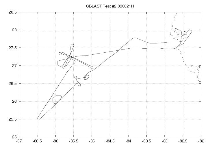 NOAA42 took off from MacDill AFB at 170522 UTC. After some maneuvering
for weather and coordination, 42 began its inbound 12-sonde run at
181457 at 26° 21'N, 85° 32' W. A real GPS sonde was dropped
(marking the handover of drops from NOAA42 to NOAA43) at 181717 at
26° 16'N, 85° 38'W. 7 more simulations of sonde drops were
made at 181747, 181816, 181846,181916,181933,181945, and 182000 UTC.
Also at 182000, a real AXBT was dropped at the innermost drop point
of the leg. About 14 minutes of simulated circling followed while
the simulated sondes were made ready. The AXBT on the outbound leg
was dropped at 183548 UTC at 26° 54'N, 85° 0'W(along with a
simulated GPS sonde). Six more simulated sondes were dropped at
183505, 183616, 183636, 185103,183733, and 183802. Finally a real
sonde was dropped at NOAA42's outermost sonde drop (where the
handover from 42 t° 43 occurred). Time of the drop was 183836
and position was 25° 47'N 86° 8'W. The end of the leg occurred
at 184720 at position 25° 29'N, 86° 32'W. From there the
aircraft headed to the stairstep IP.
NOAA42 took off from MacDill AFB at 170522 UTC. After some maneuvering
for weather and coordination, 42 began its inbound 12-sonde run at
181457 at 26° 21'N, 85° 32' W. A real GPS sonde was dropped
(marking the handover of drops from NOAA42 to NOAA43) at 181717 at
26° 16'N, 85° 38'W. 7 more simulations of sonde drops were
made at 181747, 181816, 181846,181916,181933,181945, and 182000 UTC.
Also at 182000, a real AXBT was dropped at the innermost drop point
of the leg. About 14 minutes of simulated circling followed while
the simulated sondes were made ready. The AXBT on the outbound leg
was dropped at 183548 UTC at 26° 54'N, 85° 0'W(along with a
simulated GPS sonde). Six more simulated sondes were dropped at
183505, 183616, 183636, 185103,183733, and 183802. Finally a real
sonde was dropped at NOAA42's outermost sonde drop (where the
handover from 42 t° 43 occurred). Time of the drop was 183836
and position was 25° 47'N 86° 8'W. The end of the leg occurred
at 184720 at position 25° 29'N, 86° 32'W. From there the
aircraft headed to the stairstep IP.
 After coordination the 'L' pattern began at 192948 27° 15'N,
85° 35'W, with a sonobuoy launch and a track heading for the
first leg of 120. A sonobuoy drop was also attempted at 193520 at
27° 4'N, 85° 4'W, but the buoy was not launched (failure to
launch). Several other launch attempts were made to launch this buoy,
but without success. After some maneuvering the reverse (downwind)
legs was started at 193840 26° 57'N, 85° 0'W, and the track
was 300°. The official leg was not started until 194405.
After coordination the 'L' pattern began at 192948 27° 15'N,
85° 35'W, with a sonobuoy launch and a track heading for the
first leg of 120. A sonobuoy drop was also attempted at 193520 at
27° 4'N, 85° 4'W, but the buoy was not launched (failure to
launch). Several other launch attempts were made to launch this buoy,
but without success. After some maneuvering the reverse (downwind)
legs was started at 193840 26° 57'N, 85° 0'W, and the track
was 300°. The official leg was not started until 194405.
The third sonobuoy launch was made at 194950 at 27° 13N, 85°
38'W as the planes turned to 210° track to begin the crosswind
leg. At 195800 the last sonobuoy was launched at 27° 0'N, 85°
43'W. At 200311 NOAA 42 descended to 3000 ft RA. The 3,000 ft
calibration run began at 200955 at 27° 25'N, 85° 36'W, with
a track of 200°. At 201420 27° 11'N, 85° 42'W, the
aircraft began its ascent to 13,000 ft. The 13,000 ft run began at
202332 27° 7'N, 85° 55'W, with a track of 075°, and ended
at 202920 27° 14'N, 85°N 28'W. Both legs were successful, as
NOAA 42 found clear air for the calibration. The 8,000 ft calibration
was accomplished during other parts of the mission. Thus the desired 3
heights with 5,000 ft separation was accomplished. This ended the
calibration mission. NOAA42 landed at MacDill AFB at 2120 UTC.
Evaluation :
The calibration flight was a great success. Coordination worked well.
AOC equipment as well as CBLAST specific equipment worked better than
expected, considering many instruments had been recently installed.
Peter Black considered the missions successful enough to consider the
aircraft and instruments ready for the CBLAST science missions.
Problems :
Old workstation could not be used since it was incompatible with flat
screen monitor at that station. Old monitor will be reinstalled.
Too much (legitimate) concern was regularly voiced by pilots about
possible dropping on lower aircraft. I suggest a little more horizontal
distance between upper and lower aircraft. Otherwise the 12 drop sonde
will be completely fouled up by safety concerns. Only very minor
problems with radar. No radar reboots required. Turning off
transmit and turning back on was all that was necessary.
John Gamache
Lead Project Scientist
Last update August 26, 2003
Return to Mission page.