Mission Summary
20030819H Aircraft 42RF
inter-comparison and calibration flight
with NOAA 43
Scientific Crew (42RF)
| Lead Project Scientist(s)
| Paul Chang
Sim Aberson
John Gamache
|
| Radar Scientist
| John Gamache
|
| Flight Director | Tom Shepherd
|
| Umass (IWRAP) Scientists
| Danny Feteran
Beth Kerr
|
Mission Briefing:
Flying to Buoy 42030, which will serve as 'hurricane center'. Will
practice Emanuel inspired 12-drop rapid-GPS-drop sequence. NOAA43 does
exterior four dropsondes (low-aircraft). Then NOAA 42 does interior
eight drops, but we only mark most locations instead of actually
dropping, to conserve sondes for science missions. Real BT will be
dropped at 42
'
s innermost drop point, and real GPS sonde will be
dropped at the outermost (switch off) point, to test how well the
two aircraft sonde patterns map onto each other.
Mission Synopsis:
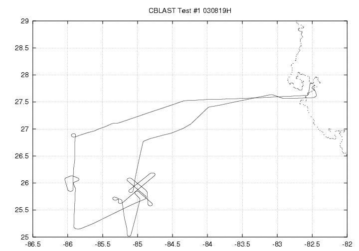 NOAA42 sortie began with a take off from MacDill AFB at 15:14:35 UTC,
and ended with a landing at MacDill at 19:07:10 UTC. The first
dropsonde run began at 160745 UTC at 26° 50'N, 85° 56'W,
with a track of 180° toward the buoy. NOAA42 launched its first
real sonde at 161620 UTC at 26° 17'N, 85° 57'W. It was
followed by simulated drops at 161650, 161720, 161745, 161805, 161820,
and 161835
UTC. At 161850 UTC 26° 5'N, 85° 57'W, simulated
GPS sonde was dropped and a real AXBT and sonobuoy. SST was 29°C
from BT. Circling began at 162810 to simulate the time for a new set
of 12 sondes to be initialized for an outbound run. The buoy 'eye' was
attained at 163220 AND 26° 0'N, 85° 55'W. NOAA42's portion
of the outbound run began with a simulated GPS drop and a real AXBT
drop at 163336 UTC and 25° 55'N, 85° 54'W. SST from this drop
was also 29°C. Six simulated GPS drops followed at 163350, 163405,
163420, 163435, 163450, and 163520 UTC. The final drop of a real GPS
sonde was made at 163650 and 25° 46'N, 85° 54'W. The
coordinated passes with NOAA43 in its 6-level stair-step pattern began
NOAA42 sortie began with a take off from MacDill AFB at 15:14:35 UTC,
and ended with a landing at MacDill at 19:07:10 UTC. The first
dropsonde run began at 160745 UTC at 26° 50'N, 85° 56'W,
with a track of 180° toward the buoy. NOAA42 launched its first
real sonde at 161620 UTC at 26° 17'N, 85° 57'W. It was
followed by simulated drops at 161650, 161720, 161745, 161805, 161820,
and 161835
UTC. At 161850 UTC 26° 5'N, 85° 57'W, simulated
GPS sonde was dropped and a real AXBT and sonobuoy. SST was 29°C
from BT. Circling began at 162810 to simulate the time for a new set
of 12 sondes to be initialized for an outbound run. The buoy 'eye' was
attained at 163220 AND 26° 0'N, 85° 55'W. NOAA42's portion
of the outbound run began with a simulated GPS drop and a real AXBT
drop at 163336 UTC and 25° 55'N, 85° 54'W. SST from this drop
was also 29°C. Six simulated GPS drops followed at 163350, 163405,
163420, 163435, 163450, and 163520 UTC. The final drop of a real GPS
sonde was made at 163650 and 25° 46'N, 85° 54'W. The
coordinated passes with NOAA43 in its 6-level stair-step pattern began
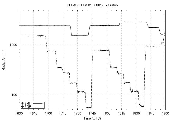 at 170137 UTC at 25° 47'N, 84° 52'W with a track at 320°.
NOAA42 then turned toward 140° to do a coordinated race track
pattern at 170706 UTC at 26° 4'N, 85° 8'W. At this time a
simulated sonobuoy was launched. At 171710 and 25° 36'N, 84°
50'W, the coordinated pattern ended. NOAA42 then broke off from
NOAA43 and performed calibration manuevers for IWRAP and testing and
calibration at 8,000 and 5,000 ft, which consisted of roll maneuvers
back and forth at 172040, and a straight and level flight path for
10 minutes from 172634 at 25° 40'N, 85° 0'W to 173613 at
25° 3'N, 85° 10'W. The IP for the crosswind coordination
was at 175540 UTC and 25° 49'N, 85° 5'W. The aircraft then
turned to 220°, after a simulated sonobuoy splash at 180222 and
26° 9'W, 84° 46'W. The 220° legs began at 180500 at
26° 7'N, 84° 53'W, and ended at 181008 and 25° 50'N,
85° 5'W. NOAA42 began its return home at 181255 at 25° 56'N,
85° 3'W.
at 170137 UTC at 25° 47'N, 84° 52'W with a track at 320°.
NOAA42 then turned toward 140° to do a coordinated race track
pattern at 170706 UTC at 26° 4'N, 85° 8'W. At this time a
simulated sonobuoy was launched. At 171710 and 25° 36'N, 84°
50'W, the coordinated pattern ended. NOAA42 then broke off from
NOAA43 and performed calibration manuevers for IWRAP and testing and
calibration at 8,000 and 5,000 ft, which consisted of roll maneuvers
back and forth at 172040, and a straight and level flight path for
10 minutes from 172634 at 25° 40'N, 85° 0'W to 173613 at
25° 3'N, 85° 10'W. The IP for the crosswind coordination
was at 175540 UTC and 25° 49'N, 85° 5'W. The aircraft then
turned to 220°, after a simulated sonobuoy splash at 180222 and
26° 9'W, 84° 46'W. The 220° legs began at 180500 at
26° 7'N, 84° 53'W, and ended at 181008 and 25° 50'N,
85° 5'W. NOAA42 began its return home at 181255 at 25° 56'N,
85° 3'W.
Evaluation :
Coordination went well. Equipment (radar, GPS, BT, IWRAP,
flight-level data) seemed to work well. Peter Black was very pleased
at how well things went considering the new pattern and that it was
the first attempt of the season to do the CBLAST pattern.
Problems :
Workstation was not aboard the aircraft. Radars had to be reset a
couple of times, but came right back up. The pace of the drops was
intense. Communication between flight director and sonde launched
was difficult since drops came so fast. It was decided a different,
third person should tell the GPS sonde operator when to launch
(Note: this seemed to go well two days later on 20030821H1).
John Gamache
Lead Project Scientist
Last update August 26, 2003
Return to Mission page.