| Lead Project Scientists |
Rob Rogers and Michael Black |
| Radar Scientist |
Peter Dodge and Michael Black |
| Workstation Scientist |
Peter Dodge |
| Dropwindsonde Scientist |
Michael Black |
| AXBT Scientists |
Joe Cione and Eric Uhlhorn |
| Observer | Mark Croxford (U Hawaii) |
Mission briefing:
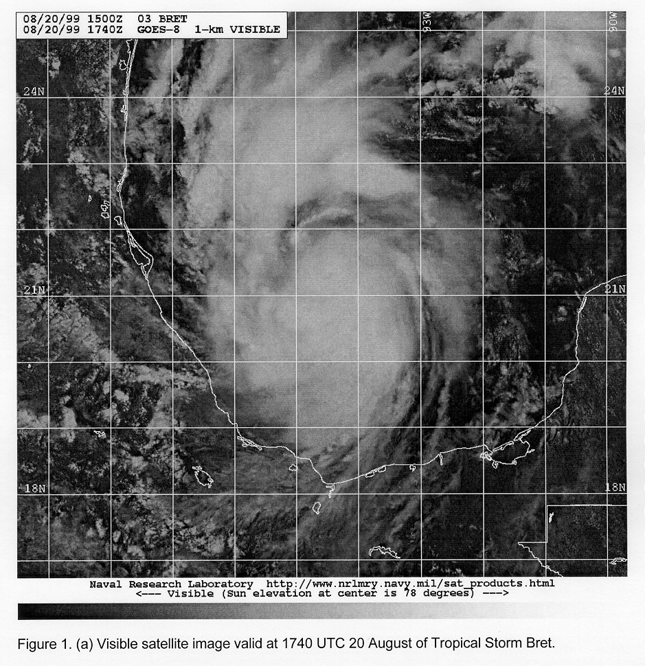
Tropical Storm Bret had its origins as a low-level circulation that developed underneath and to the west of a pronounced mid-level cyclonic circulation over the Yucatan Peninsula. Convection initially developed on the western side of the low-level circulation and then quickly wrapped around the system, at which point the system was named a depression. Intensification to a tropical storm soon followed (Fig. 1a). With low values of vertical shear and high sea-surface temperatures, it was decided that Tropical Storm Bret had the potential to rapidly intensify. Consequently, aircraft 43RF was tasked to investigate the system, with the goal of sampling the inner core environment of a tropical storm before it underwent rapid intensification. Additionally, an air-sea interaction component was included to map out the oceanic thermal profiles both undemeath and in the near-environment of the storm. Because Bret was expected to remain relatively stationary and close to land, the G-IV was not tasked to fly.
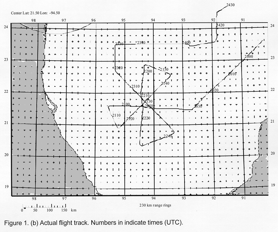
The flight plan called for a mod)fied XCDX experiment with 75-nm flight legs (Fig. 1 b). To fly at levels as close to 500 mb as possible, the mission was designed to operate at 16,000 ft, unless icing became a problem, at which point the P-3 would descend to 14,000 ft. Approximately 20 dropsondes and 20 AXBTs were planned to be dropped within the storm's circulation and in the path of the storm's expected track.
Mission synopsis:
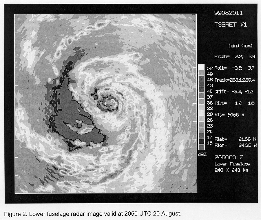
The flight departed from MacDill AFB at 1800 UTC 20 August and returned to MacDill at 0217 UTC 21 August. By the time the initial point was reached (2031 UTC), Bret was moving north at about 8 kt. Lower fuselage radar (Fig. 2 ) showed distinct bands of convection beginning on the north side and wrapping around the east and south of the storm. Maximum flight-level winds within this convection were 56 kt, while GPS sondes dropped along this leg measured a low-level wind of 60 kt. The center appeared quite small (~ 5-10 nm) on radar, making it difficult to get a position fix. These difficulties were further evident from the fact that a drop in the center produced a surface wind of 35 kt.
Later in the mission (2230 UTC), the core of the system took on more of a stratiform character, with precipitation wrapped from the northwest and north to the east of the center. Some convective elements were embedded within this rain, but most of the deep convection was in an east- west oriented band about 100 nm to the north of the center. During the final leg, which passed through this convection, the plane was struck by lightning and lost its HF antenna.
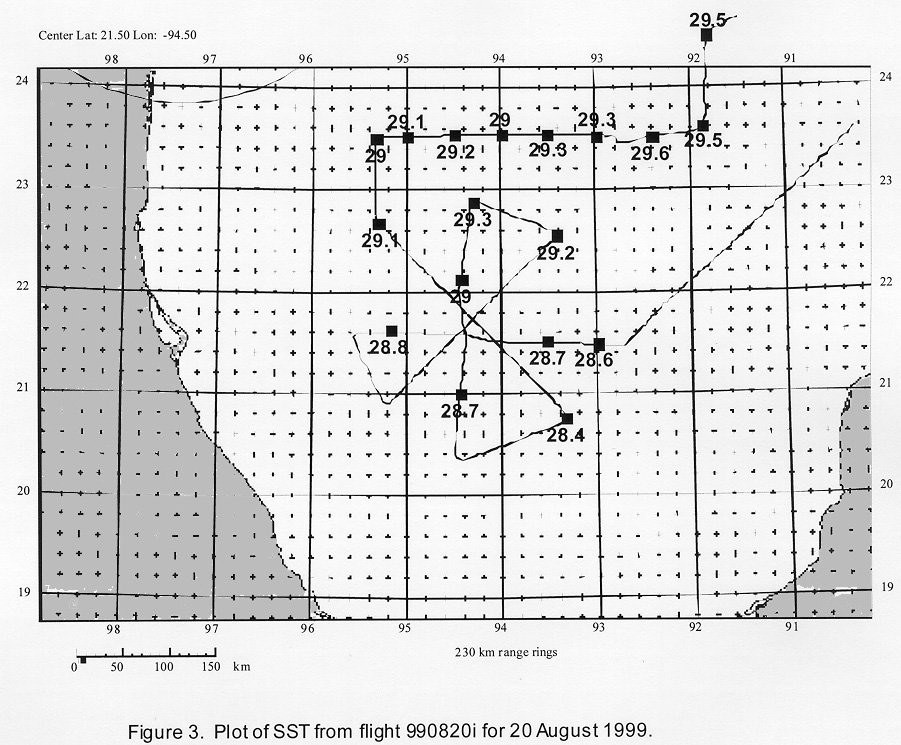
Sea-surface temperatures within the system ranged between 28° and 29°C (Fig. 3), with a minimum of 28.4°C in the right-rear quadrant to 29.3°C to the north of the storm. SSTs within the core were an impressive 28.7-29.0° C. Further to the north and northeast of the storm, SSTs were between 29° and 29.5°C with deep mixed layers, suggesting a favorable oceanic environment for continued intensification, provided the storm moved at more than 5 kts.
Evaluation:
This mission was successful in capturing the inner-core structure and mapping out the oceanic thermal profiles of a tropical storm before undergoing rapid intensification. A total of 19 GPS sondes were dropped, with only 3 partial failures, while 20 of the 22 AXBTs that were dropped worked properly. Other than a 10-min period between 1952 and 2002 UTC when the tail radar was down, both the lower fuselage and tail radar worked well.
Rob Rogers
5 September 1999