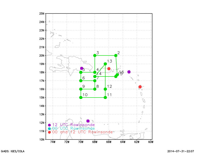
Proposed track
| Aircraft Commander | Justin Kibbey |
| Co-pilot | Chris Kerns |
| Co-pilot | Adam Abitbol |
| Navigator | Tim Gallagher |
| Flight Engineer | Ken Heystek |
| Flight Engineer | Chris Lalonde |
| Flight Director | Ian Sears |
| Flight Director | Mike Holmes |
| System Engineer | Terry Lynch |
| System Engineer | Bill Olney |
| Data Technician | Joe Bosko |
| AVAPS | Todd Richards |
| LPS | Eric Uhlhorn (HRD) |
| Radar | Rob Rogers (HRD) |
Mission Plan :
NOAA42 will conduct an HRD-tasked Ocean Survey mission ahead of Bertha. Take off is from St. Croix, USVI at 18:00 UTC and recover at St. Croix, USVI by 02:00 UTC the follwing day.
|
Hurricane Research Division August 01, 2014 9:12:15 AM Aircraft: N42RF Proposed takeoff: 02/1400Z
TURN LOCATIONS
| #
| LAT
| LON
| LEG
| TOTAL
| TIME
|
| deg min
| deg min
| nm
| nm
| hr:mm
| 2 | 20 00 | 65 00 | 139. | 139. | 0:36
| 3 | 20 00 | 68 00 | 169. | 308. | 1:19
| 4 | 18 00 | 68 00 | 120. | 428. | 1:50
| 5 | 18 00 | 70 00 | 114. | 543. | 2:20
| 6 | 17 00 | 70 00 | 60. | 603. | 2:35
| 7 | 17 00 | 68 00 | 115. | 718. | 3:05
| 8 | 16 00 | 68 00 | 60. | 778. | 3:21
| 9 | 16 00 | 70 00 | 116. | 893. | 3:51
| 10 | 15 00 | 70 00 | 60. | 954. | 4:06
| 11 | 15 00 | 66 30 | 203. | 1157. | 4:58
| 12 | 16 00 | 66 30 | 60. | 1217. | 5:13
| 13 | 19 00 | 66 30 | 180. | 1397. | 5:57
| 14 | 17 30 | 68 00 | 124. | 1522. | 6:28
| 15 | 17 30 | 65 00 | 172. | 1694. | 7:10
| | ||||||||||||||
Mission Summary :
| Take off | Landing
| St. Croix, USVI | 17:32 UTC
| St. Croix, USVI | 01:29 UTC
| | ||
Mission Data :
 Flight track |
 Temperature and Moisture |
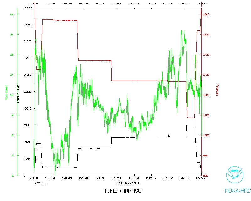 Wind and Atlitude |