Proposed track
| Aircraft Commander | Harris Halverson |
| Co-pilot | Cathy Martin |
| Co-pilot | Pat Didier |
| Navigator | Chris Sloan |
| Flight Engineer | Ken Heystek |
| Flight Engineer | C. Lalonde |
| Flight Director | Ian Sears |
| Flight Director | Mike Holmes |
| System Engineer | Terry Lynch |
| Data Technician | Dana Naeher |
| Data Technician | James Wernecke |
| LPS | Sim Aberson |
| Dropsondes/AXBT | Kathryn Sellwood |
| Radar | Jun Zhang |
| Observer | Joseph Patton (Univ. Okla.) |
| Observer | Kelly Nuñez (Univ PR) |
| Observer | Randall Hergert (USF) |
Mission Plan :
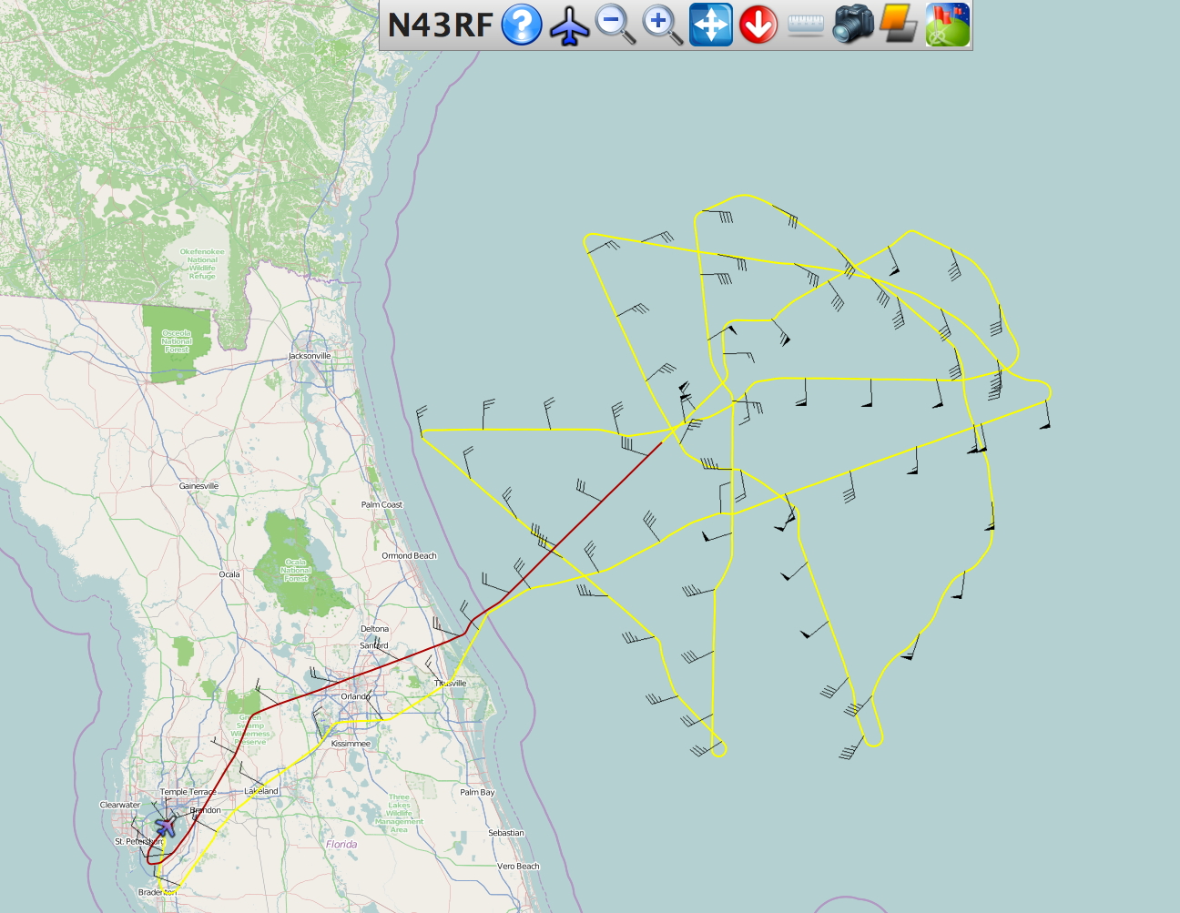
Conduct EMC-tasked TDR mission into Tropical Storm Arthur, which was moving slowly off the east coast of Florida. The mission was conducted at nearly the same time as an NHC-tasked synoptic surveillance mission around Arthur, allowing for exceptional data coverage in the environment. The proposed flight pattern was for an initial figure-4 pattern followed by a circumnavigation of the storm outside the radius of maximum wind speed, and ending with a second, rotated, figure 4.
Mission Summary :
| Take off | Landing
| MacDill AFB, FL | 18:12 UTC
| MacDill AFB, FL | 01:27 UTC
| | ||
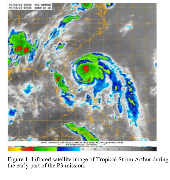
Tropical Storm Arthur was strengthening slowly during the morning as convection started to develop in all quadrants of the tropical cyclone (Fig. 1). Dry air previously seen over the western semicircle of the storm and over Florida was gradually moistening, though some remained in the circulation. Arthur was also encountering weak shear, as shown by the nearly circular shape of the central dense overcast.
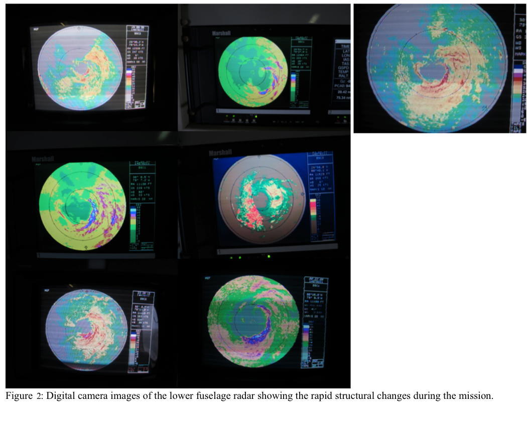
During the first figure-4 pattern, the convective structure of Arthur was as expected from satellite, with convection surrounding the core, but with a large wavenumber-1 pattern as well (Fig. 2). The intensity of the convection was in the 40-dBZ range, what is usual for a tropical cyclone of this intensity and structure. However, during the flight, the structure changed rapidly a number of times: a very asymmetric structure with very strong (50-55-dBZ) convection in the eastern semicircle and little convection on the west side developed, then returned to the more symmetric pattern initially seen. This change happened three times during the mission. The periods of time with the intense convection were accompanied by moderate turbulence. The very strong convection caused the circumnavigation of the storm to be canceled.
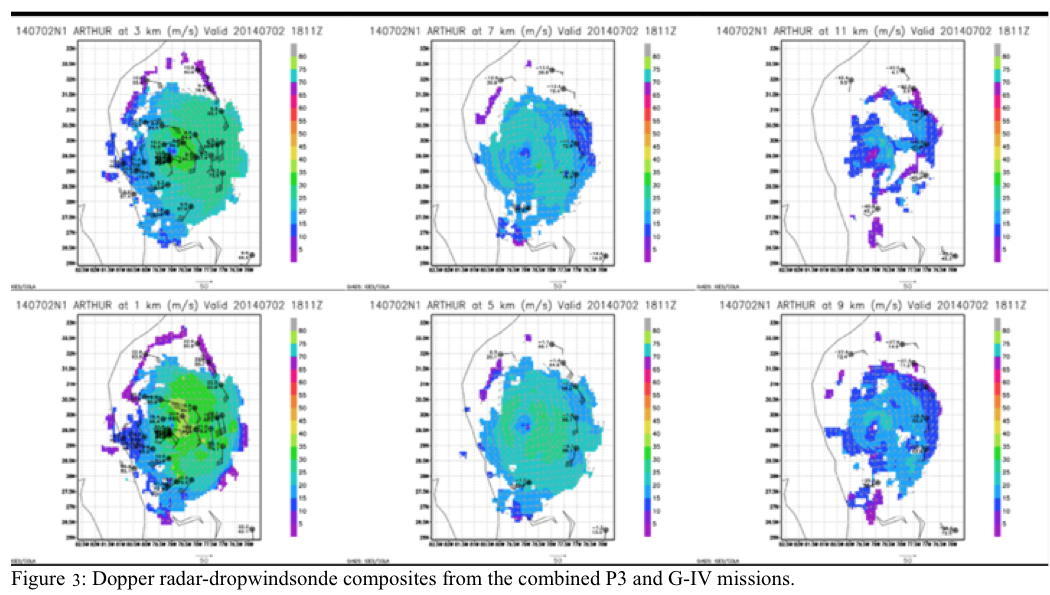
Five radar analyses were successfully completed and transmitted from the plane with the help of John Gamache and Sonia Otero on the ground. The Doppler radar-dropwindsonde composites from the P3 and G-IV missions show that there were wind speeds approaching 80 kt at 1-km altitude, confirming estimates that Arthur was approaching hurricane intensity during the mission. The wind field became more symmetric with altitude into mid-levels. Due to the very strong convection, the analysis was able to extend above 16 km, a rarity for tropical cyclones in the Atlantic subtropics.
Due to the very strong convection experienced during the mission, the mission may be very useful as a long convective-burst mission.
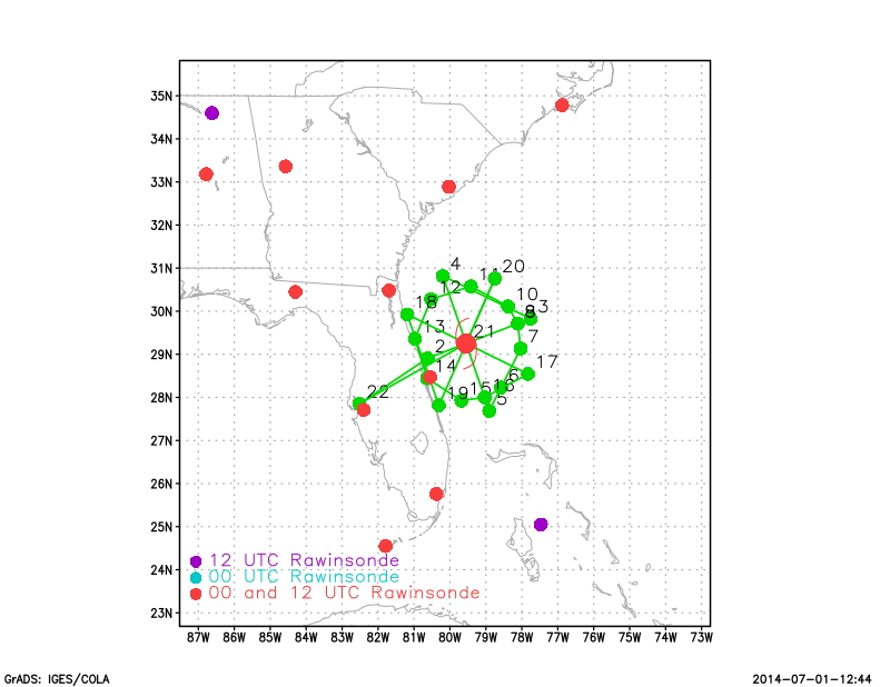
22 dropsondes launched, 21 good, 1 bad.
Problems :
The circumnavigation was canceled due to the convective structure of the tropical cyclone. The goal was to fly around the core outside the radius of maximum wind speed. In mature hurricanes, this region is usually a 'most' with relatively low-reflectivity scattering and little convection. In this case, the strong convection on the east side that periodically developed prohibited the aircraft from completing the pattern. This pattern will be easier to complete in a mature tropical cyclone.
There were some problems with the dropwindsonde-processing system. The data did not go the correct directory on the processing computer, and some data had to be input manually.
No dropwindsonde data from the radius of maximum wind speed were successfully gathered. One time, the AVAPS operator did not have a dropwindsonde ready despite being notified. The second time, we had to turn to avoig 50+-dBZ convection in the eyewall. By the time we got out of the turn and the SFMR returned, we were well inside the radius of maximum wind speed. An anticyclonic turn of the aircraft would have prevented this problem, but the LPS did not realize that at the time.
The LPS-radar station was very warm during the flight, even though the rest of the aircraft was relatively cool.
The LPS computer had no situational awareness software on it, only Xchat. This was corrected for the subsequent flight.
Sim Aberson
July 31, 2014
Mission Data :
 Flight track |
 Temperature and Moisture |
 Wind and Atlitude |
Flight Director's log | Lead Scientist's log | Radar log | Dropsonde log
NetCDF data | 1 second data | serial data