Two predictor and predictand data sets were utilized. The years from 1950 through 1994 were chosen as the dependent data set from which the multiple regression equations were derived. 43 years of data are used to create the predictors for each equation, but because of the variation of lead times the predictand data sets vary as shown in Table 1. The SOI data set was computed as the standardized Tahiti minus Darwin (Fig. 1) sea level pressure difference, analyzed as monthly values. Following Trenberth and Shea (1987) the SOI was created from monthly sea level pressure anomalies relative to 1950-1979 mean values, and standardized by dividing by climatological standard deviation, yielding the difference between the standardized Tahiti minus the standardized Darwin sea level pressure anomalies. These data were retrieved from the Climate Prediction Center's anonymous ftp site (140.90.50.22).
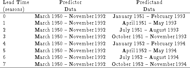
Table 1: Description of data time series used to create
the predictor and predictand data sets for the
ENSO-CLIPER at each of the lead times.
The SST data were the high-resolution global SSTs (Smith et al. 1996), which are based upon optimal interpolation of in situ ship and buoy data, supplemented by satellite SST retrievals as available. The SSTs are monthly values on a 2° grid spacing for 1950-1990. Areal-averaged anomalies were computed from a 1950-1979 monthly climatology to derive the four standard SST indices commonly utilized for ENSO monitoring (e.g. Barnston and Ropelewski (1992)). These were supplemented with a more detailed (1° x 1°) data set described in Reynolds and Smith (1995) which is available for the period 1991-present. These areas, shown in Fig. 1, include ``Niño 1+2" (0-10°S, 80-90°W), ``Niño 3" (5°N-5°S, 90-150°W), ``Niño 4" (5°N-5°S,150°W-160°E), and ``Niño 3.4" (5°N-5°S, 120-170°W). The Niño 3.4 index has been identified as the SST region having strongest concurrent association with mid-latitude and tropical ENSO-forced circulation variations (Barnston et al. 1996).