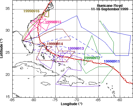
On 9 September NHC tasked N49RF for a synoptic surveillance mission in Hurricane Floyd east of the Leeward Islands. N49RF took off at 1730 UTC from MacDill AFB and landed in St. Croix at 0230 UTC. The dropsondes should provide excellent documentation of the weakness in the ridge to the NW of Floyd.
GPS dropsonde (HSA) data format
| Storm/ Date | Aircraft (Duration) | Altitude | Experiment/ Pattern | Comments (expendables) |
| Floyd | ||||
| 9 September | N49RF (9 h) GPS dropsondes | 45 kft | Synoptic Surveillance Experiment
N49RF sampled environmental circulation. |
|
| Storm/ Date | Aircraft (Duration) | Altitude | Experiment/ Pattern | Comments (expendables) |
| Floyd | ||||
| 11 September | N42RF (9 h) mission summary
One minute listing N43RF (9.2 h) mission summary
WC-130 |
14-22 kft
14-22 kft 5 kft |
2-Plane Synoptic Surveillance Experiment
N43RF sampled environment NW of Floyd, passed through storm center, and returned to Miami. N42RF sampled environment N and NE of storm to within 200 km NW of center, recovering in Bermuda. AFRES recon. |
|
On 12 September NHC tasked N49RF and N42RF for a 2-plane synoptic surveillance mission. N49RF would depart from MacDill AFB at 1730 UTC and fly to the northeast covering the oceanic areas north and west of Hurricane Floyd, and re turn to Miami. Meanwhile, N42RF, after recovering the night before in Bermuda, would takeoff at 1730 UTC, cover the area northeast of Floyd, fly a figure four pattern through Floyd's center, and land in St. Croix, USVI. The two aircraft surveillance missi on provided important information from both the periphery and inner core regions of an intense hurricane. The flights were conducted a couple of days before a potential landfall in the SE United States, including Florida.
| Storm/ Date | Aircraft (Duration) | Altitude | Experiment/ Pattern | Comments (expendables) |
| Floyd | ||||
| 12 September | N49RF (9 h) GPS dropsondes
N42RF (9.2 h) mission summary
WC-130 |
45 kft
14-22 kft 10 kft |
2-Plane Synoptic Surveillance Experiment
N49RF sampled environment N and W of Floyd recovering in Miami. N42RF sampled environment E of Floyd, did figure-4 with 75 nm legs in Floyd's core, and recovered in St. Croix, USVI at 0251 UTC. AFRES recon. |
|
On 13 September NHC tasked N49RF and N42RF for a 2-plane synoptic surveillance mission in Floyd, while N43RF did Extended Cylone Dynamics eXperiment (XCDX) mission with added oceanographic observations. N42RF took off from St. Cr oix, USVI at 1730 UTC and recovered at Tampa International at 0245 UTC. N49RF and N43RF took off from Miami at 1730 UTC and N49RF landed in Savannah, GA at 0230 UTC. N43RF landed in Miami at 0230 UTC changed HRD crews and then ferried to MacDill AFB landi ng at 0345 UTC.
| Storm/ Date | Aircraft (Duration) | Altitude | Experiment/ Pattern | Comments (expendables) |
| Floyd | ||||
| 13 September | N49RF (9 h) GPS dropsondes
N42RF (9.2 h) mission summary
N43RF (9.2 h) mission summary
WC-130 |
45 kft
14-22 kft 12 kft 10 kft |
2-Plane Synoptic Surveillance Experiment
N49RF and N42RF sampled Floyd environment. N42RF figure-4 with 60 nm legs in Floyd's core. N43RF Extended Cyclone Dynamics Experiment (XCDX) rotating figure-4 with 130 nm legs in Floyd's core. GPS drops on ends of legs, 65 nm from center, and in eyewall on all cardinal directions. Stopped in Miami then recovered at MacDill AFB AFRES recon. |
|
On 14 September N49RF synoptic surveillance mission in Floyd with takeoff from Savannah, GA at 1730 UTC and recovering in St. Croix, USVI at 0305 UTC. N43RF was tasked to do a two-plane synoptic surveillance mission with N49RF in to Hurricane Floyd as it passed Nassau, Bahamas with a takeoff from MacDill AFB at 1730 UTC and landing at Tampa International Airport around 0230 UTC.
| Storm/ Date | Aircraft (Duration) | Altitude | Experiment/ Pattern | Comments (expendables) |
| Floyd | ||||
| 14 September | N49RF (9 h) GPS dropsondes
N43RF (9.2 h) mission summary
WC-130 |
45 kft
14-22 kft 10 kft |
2-Plane Synoptic Surveillance Experiment
N49RF sample environment of Floyd and Gert. N43RF sample environment S and E of Floyd and figure-4 with 50 nm legs in Floyd's core. GPS drops on ends of legs and in eyewall on cardinal directions. One drop in eye on first pass through center with backup on second pass. Final leg E-W pass N of storm over buoys E of Cape Canaveral, FL. Dropped string of AXBTs to sample SST and MLD in front of storm in region where Dennis passed. Dropped GPS-sonde near buoys and C-MAN sites AFRES recon. |
|
On Wednesday 15 September N43RF was tasked to do a single plane XCDX/Air-Sea Interaction experiment into Hurricane Floyd while it passed E of Jacksonville, FL with a takeoff from Tampa International at 1948 UTC recovering back in Tampa.
| Storm/ Date | Aircraft (Duration) | Altitude | Experiment/ Pattern | Comments (expendables) |
| Floyd | ||||
| 15 September | N49RF (9 h) GPS dropsondes
N43RF (9.2 h) mission summary
WC-130 |
45 kft
8 kft 10 kft |
Modified Extended Cyclone Dynamics (XCDX)/Air-sea Interaction/Windfields at Landfall Experiment.
N49RF Synoptic Surveillance of Hurricane Gert. N43RF did 3 rotated figure-4 with 120 nm legs. AXBT and sonde drops on ends of legs, 60 nm from center, near any C-MAN or buoys, and in eyewall on all cardinal directions. 3 drops in eye on first, fourth, and sixth passes through center. Also two legs along coast NW of storm for storm surge mapping and to drop sondes in offshore flow and near 3 instrumented towers and DOW. AFRES recon. |
|
On Thursday 16 September N42RF scheduled for Windfields at Landfall mission with take off time 0300 UTC. At briefing time, the pilots expressed concern about operating over land where mesovortex signatures had earlier been report ed north of Floyd. Therefore, over land portion of the flight plan was eliminated. The remaining portions of the landfall experiment included an initial "figure 4", a series of coastal legs and a box pattern.
| Storm/ Date | Aircraft (Duration) | Altitude | Experiment/ Pattern | Comments (expendables) |
| Floyd | ||||
| 16 September | N42RF (9.2 h) mission summary
GPS dropsondes AXBT data One minute listing WC-130 |
8 kft
10 kft |
Windfields at Landfall Experiment
N42RF 100 nm legs with GPS drops at C-MAN sites, buoys, and portable towers and mesonets from OU and TTU, on ends of legs, and in eyewall. Flight legs had radials off KLTX, KMHX, and the DOW. AXBT deployments were made along Gulf Stream. AFRES recon. |
|