WHAT's NEW
 US Weather Research Program (USWRP)


NOAA is pleased to have NASA as a partner in the 1998
hurricane research program. This collaboration is the beginning of a renewed
effort to unravel the mysteries of these devastating storms under a multi-agency
(DoD, NASA, NOAA, and NSF) effort over the next 5-6 years, the U.S. Weather Research Program (USWRP).
USWRP is focused on the meteorological research community's contribution
to the reduction in the impacts of disastrous weather on the nation, in
particular hurricane landfall. Addition of CAMEX-3
(Third Convection and Moisture Experiment) to the NOAA hurricane research
program is a prototype for this interagency cooperation.
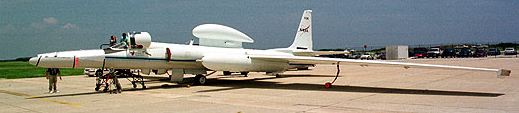
The NASA DC-8 and ER-2
research aircraft are available for hurricane research flights in the Atlantic
basin for the first time under the CAMEX-3 (NASA aircraft last flew in hurricanes
over 19 years ago). These research aircraft provide a unique capability
to sample the hurricane at altitudes we haven't sampled in over 20 years.
The DC-8 provides a high altitude research platform for a variety of remote sensors,
dropsondes and microphysics measurements in the inner core of the storm,
while the ER-2 provides in situ data in the lower stratosphere, and remote sensed measurements
through the troposphere. The research plans for this season include flight
tracks for the NASA aircraft to take advantage of their unique observational
capabilities. All of these experiments have been flown in past years, but
new emphasis is put on adding the enhanced capabilities of the DC-8 and
ER-2 to that of the WP-3Ds.
The most important CAMEX-3 contribution to hurricane research is improved
understanding of the distribution of moisture and precipitation in the inner
portion of the storm. In particular, three specific areas deserve mention:
- the addition of in-situ microphysics
observations at 8-10 km altitude (where we lack it the most), together
with the remote sensing observation of precipitation in the vertical will
greatly increase our knowledge of the precipitation processes active in
the storm. NASA brings a lot of expertise in interpretation of remote sensing
data for rainfall estimation needed to improve hurricane precipitation
forecasting.
- an addition that may prove to be equally valuable is remote sensed
humidity data collected by the LASE
instrument within and surrounding the storm. These profiles will be
invaluable to understanding the role environemental humidity plays in storm
structure and intensity changes. As a side benefit, the profiles will aid
calibration of altitude assignments for the GOES water vapor winds developed
at NOAA/CIMSS at
the University of Wisconsin.
- airborne Doppler laser measurements from MACAWS
will enable study of eye dynamics, leading to a better understanding of
the air flow into and out of the eyewall. Combined with NOAA WP-3D chaff
drops in the eye, these data should revolutionize our understanding of
eye circulation evolution.
Finally, DC-8 flights into the hurricane core provide invaluable experience
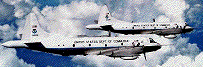
for future NOAA G-IVSP flights into the storm.


©1998 NOAA/AOML Hurricane Research Division
 Back to index
For information about NOAA Hurricane Field Program
marks@aoml.noaa.gov
For information about NASA CAMEX-3 Robbie.Hood@msfc.nasa.gov
For information about USWRP carbone@ncar.ucar.edu,
or snelson@nsf.gov
Updated Tuesday, 15 September 1998