FLORIDA BAY RAINFALL
Principal Investigator:
Frank Marks
Collaborating scientist(s):
Paul Willis (CIMAS)
Dean Churchill (UM/RSMAS)
Peter Dodge
Objective:
This research attempts to provide fields of rainfall accumulation over Florida Bay and the Everglades
using the National Weather Service WSR-88D radars in South Florida (Melbourne, Miami, Tampa,
and eventually Key West) in support of the Florida Bay Program.
Rationale:
We are evaluating a number of methods to produce the rainfall accumulations, together with
techniques to fine tune the radar reflectivity/rainfall algorithms, and assess the accuracy of the radar
rainfall estimates.
Method:
HRD has developed a probability matching method (PMM) to derive the relationship between
observed radar reflectivities (Ze) and concurrently measured rainfall rates from drop size distributions
(DSD) from an aircraft disdrometer (Marks et al 1993). This method constrains the Ze-R function so
that the probability density functions of the radar data and the drop size distribution(or gage) data
match. The method allows actual radar data to be compared to simultaneous rainfall data, even at large
ranges.
Accomplishment:
Through one month of effort in FY 95 HRD has collected 18 h of NOAA P-3 aircraft drop size
distributions (DSD) over three days (26, 28, and 29 September) in range of two South Florida
WSR-88D radars.(figure 1)
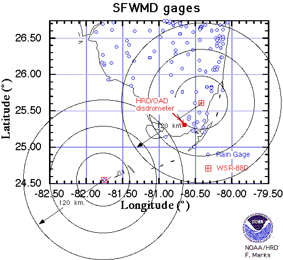
HRD has also established a high temporal resolution rain gage and disdrometer site in the Everglades
at the US National Park Service Research Center with the help of NOAA/AOML Ocean Acoustics
Division (OAD).(figure 2)
The efforts over the next year will focus on five activities:
- Produce daily and monthly accumulated precipitation atlases for Florida Bay and adjacent areas
on a demonstration basis. Update the atlases based on improvements of the Z-R relationship
using the PMM methodology. Produce higher resolution products for special cases and projects,
i.e. heavy precipitation events, onset of wet season, etc. Make these data available via the Internet
to other federal, state and local groups performing research in Florida Bay.
- Collect a sample of NOAA WP-3D DSD in range of the South Florida WSR-88D radars and
apply these data within a PMM methodology to refine the rainfall algorithm as a function of
range and rainfall type.
- Instrument a van using an aircraft PMS optical hydrometeor spectrometer (borrowed from
NOAA AOC) and PC-based data system and make transects of DSDs across the Everglades
during precipitation events as input to the PMM methodology.
- Collaborate with OAD to analyze disdrometer measured DSD and high resolution gage data at
an Everglades site.
- Use available rain gage data to assess the accuracy of the WSR-88D surface rainfall estimates.
High time resolution (1-5 min) gage data will be used in the PMM methodology if available
from OAD, or other source.
Key reference:
Marks, F.D., D. Atlas, and P.T. Willis, 1993: Probability-matched reflectivity-rainfall relations
for a hurricane from aircraft observations. J. Appl. Meteor., 32, 1134-1141.
Click here to return to the AOML project overview page.
Click here to return to the Coastal Ecosystems Health page.