The previous chapter discussed the great destructive potential of a hurricane. But even though hurricanes can be very destructive, anomalies on climatic scales can bring devastation that equals, or even exceeds, that of hurricanes. In terms of loss for the U.S. alone, a drought/heatwave which occurred during the summer of 1988, is estimated to have caused 5,000 to 10,000 deaths and 40 billion in damages. During June-September 1980, a similiar event caused an estimated 1,300 deaths and 20 billion in damages. Just as too little precipitation can be terribly destructive, so can too much. During the summer of 1993, the estimated toll of the prolonged flood in the U.S. midwest was 43 deaths and more than 12 billion in damages. On a global scale, the 1982-1983 El Niño is estimated to have caused more than 8 billion in economic damages. Over the millennia, the waxing and waning of entire cultures is believed, in part, to be related to regional climatic change.
Human activities are attuned to normal conditions; examples include agriculture, fishing, water management (irrigation, hydroelectric power) and planning of fuel oil allotments. As the climatic anomalies noted above demonstrate, departures from normal conditions can cause severe disruption, loss of life and substantial economic dislocation. The impact of an anomaly will be magnified if it develops without warning because preparation will be minimal. So it is easy to appreciate the value of an accurate forecast of occurrence, extent, and intensity. Unfortunately, this is a difficult chore, because the coupled ocean-atmosphere system is chaotic and its evolution is extremely complex.
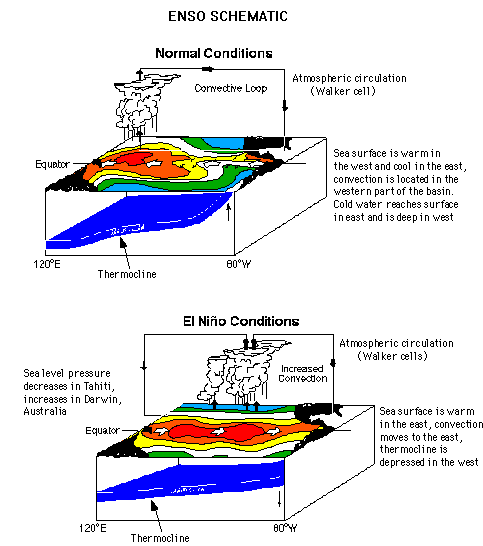
Nevertheless, the enormous inherent value of accurate climatic predictions induces many organizations to undertake this demanding chore. One recent success includes studies in the Pacific that connect the sea surface temperature variability in this region to large-scale climatic variations. Often termed ENSO (El Niño-Southern Oscillation), this variation is distinguished both by an oscillation (see-saw) between eastern and western regions of the atmosphere that overlays the tropical Pacific Ocean, and to a corresponding warming and cooling of the upper ocean temperature in the eastern and central Pacific. The temporal scale of these oscillations varies roughly between three and nine years, and the effects propagate well beyond the tropical Pacific.
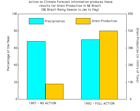
Predicting the occurrence of sea surface temperature anomalies associated with the ENSO has great value. For example, Brazil has used such predictions to provide guidance to farmers regarding choice of crop, planting date, etc. In northeast Brazil, results show that previous to the availability of forecasts, precipitation below normal by more than 20% could lead to crop production of more than 80% below normal. With forecast information, the same drop in rainfall led to crop production only about 20% below normal--a substantial improvement.
ENSO also affects the U.S. During an El Niño, the northwest is warmer and drier than usual while the southeast experiences cooler and wetter weather. In the southeast, some crops (cotton) prefer these conditions while others (corn) do not. Recent economic assessments of increased forecast accuracy for El Niño suggest that U.S. agriculture could benefit by 100 million dollars or more. El Niño conditions are also used to predict the expected number of hurricanes in a given year.
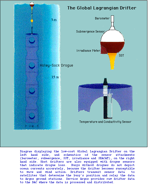
The sea surface temperature and the underlying thermal structure of the ocean are believed to hold the key to forecasting ENSO variations. Recently, the National Weather Service has begun using such information to prepare experimental climate forecasts that are being issued to the public. AOML provides many of the observations that are essential to the climatic forecast activities of the National Weather Service. Using cost-effectiveness as a principal criterion, AOML has concentrated on refining and extending the use of drifting buoys and expendable bathythermographs (XBT's) to probe the evolution of the temperature structure of the upper ocean. A drifting buoy is an inexpensive, autonomous device which is deployed by ships of opportunity. Distributed throughout the oceans of the world, it is designed to drift freely with the ocean surface currents, has an average lifetime of more than a year, and can measure sea surface temperature, surface currents, and sea level pressure. These data are then transmitted back to shore via satellite. The Global Drifter Center at AOML has responsibility for the logistics of drifter deployment and quality control of the resulting data. In July 1995, data were logged from more than 750 buoys.
An expendable bathythermograph (XBT) is another inexpensive device which is also deployed by ships of opportunity. An XBT is a small instrument that is dropped into the ocean from a ship. During its descent at a constant rate, an XBT measures the temperature of the seawater through which it descends, and sends these measurements back to the ship through two fine wires that connect the ship to the instrument. XBTs generally have a depth limit of 750 meters, but some reach depths of 1800 meters. Many ships relay summaries of the vertical profiles of temperature back to the shore by satellite. Meteorological centers throughout the world receive data from both the XBTs and the buoys via a global communications network, and use it to prepare the analyses that are essential for forecasts of weather and climate. The complete vertical temperature profiles are sent to data collection centers after the ships reach port. The Upper Ocean Thermal Center at AOML has responsibility for quality control of an average of 2,000 XBTs per month.
Observations from buoys and XBTs have other uses as well. AOML scientists have used the data to verify the models being developed for climatic forecasts, and to study climatically important upper ocean processes. In particular, these data showed that the climatological, upper-ocean current structure at the equator disagreed with that calculated by the analysis/forecast model. This led to an intensive examination of model parameterization, which is still ongoing. In another study, the heat flux due to tropical instability waves was shown to be an important contributor to oceanic heat balance at the equator. Buoy data from the eastern Pacific also revealed that intense vortices, which were believed to develop primarily in western boundary currents (Gulf Stream, Kuroshio), also occur in eastern boundary currents. Propagating westward from the Central American coast, these vortices provide a mechanism for transporting nutrient-rich coastal water out to the open ocean, thereby having the potential to impact biological productivity and pelagic fisheries, e.g., tunas.
The ENSO is not the only atmospheric pattern that is known to impact weather and climate. A similar phenomenon called the North Atlantic Oscillation (NAO) occurs over the Atlantic Ocean. The NAO is characterized by an oscillation, or mass exchange, between a low pressure region over Iceland and a broad high pressure belt centered at about 40°N in the North Atlantic. The high pressure region is sometimes termed the Bermuda or Azores High. Analogous to the ENSO, the NAO is associated with sea surface temperature anomalies in the North Atlantic. These exhibit their strongest signature in a region south of Newfoundland. The climatic impact of changes in the NAO is expressed, in part, by the severity of winters between Greenland, Labrador and northwest Europe, where one will be cold while the other is warm. In the U.S., changes in the NAO are correlated with winter temperatures and precipitation over the eastern part of the country.
In the tropical Atlantic, sea surface temperature anomalies correlate with the regional climates of Africa and South America. Recent studies at AOML also show correlations between tropical sea surface temperature and U.S. rainfall. Although historical practice has been to investigate anomaly structures in the tropics independently of the NAO, current directions of research suggest that improvements in predictability will demand consideration of the entire northern hemisphere basin.
To this end, the Upper Ocean Thermal Center at AOML is working closely with the National Centers for Environmental Prediction to develop experimental forecast models. The Upper Ocean Thermal Center is a cooperative venture between AOML and other NOAA elements (National Centers for Environmental Prediction, National Ocean Service). Scientific expertise at the Upper Ocean Thermal Center is used to establish grids for cost-effective sampling of the upper ocean using XBTs in the Atlantic basin; quality control of the data is also provided.
The Upper Ocean Thermal Center conducts model verification studies and scientific investigations that seek to improve model physics and assimilation procedures. Preliminary studies indicated that the model accurately simulates upper ocean temperature structure except in the vicinity of the Gulf Stream. Here it was found that not using observations from this vicinity in the assimilation procedure resulted in less representative simulations. Another important fact has emerged from an examination of the observations. Sea surface temperature anomalies in the Atlantic can persist for more than a decade and propagate throughout the entire northern basin. Propagation speeds are slow (1 to 4 kilometers/day) and some of the anomalies can have a substantial depth expression. A review of the limited historical upper ocean temperature data indicates that sea surface temperature anomalies on decadal temporal scales can extend to 400 meters depth. These decadal signals appear correlated with decadal signals in the NAO.
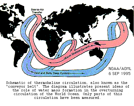
On decadal and longer temporal scales, the transport of heat by the ocean is central to understanding climatic variability. An important transport mechanism is a meridional overturning circulation driven by temperature and salinity variations. The thermohaline circulation in the North Atlantic consists of warm water which flows across the equator and toward the North Pole, whereas cold water in the northern regions sinks to great depths and flows back toward the equator. These flows are part of the global ocean thermohaline circulation, which extends into other ocean basins. The pathways of the thermohaline circulation in the Atlantic are complicated.
AOML has studied the upper and lower limbs of the overturning circulation with emphasis on the inter-gyre exchanges from the tropics to the subtropics. In the upper layer, the conventional notion of transport is northward from the tropical to the subtropical gyre. However, AOML has found significant flows in the opposite sense that are concentrated along the western boundary. Further downstream, measurements in the southern passages of the Caribbean Sea (between the lesser Antilles) suggest that throughflow from the southern hemisphere is about one-half the conventionally accepted value. These results are consistent with recent model simulations of the basin.
AOML has studied the deep equatorward flow along the western boundary and associated recirculation gyres. These studies indicate that the deep flow, known as the Deep Western Boundary Current, is indeed continuous from the subtropics to the equator and that local as well as larger-scale, deep recirculation gyres are located offshore of the Deep Western Boundary Current. The latter features have a significant effect on ventilating the ocean interior.
The increased understanding of these features will continue to improve the forecast models that are so essential to the successful prediction of climatic variability.
Click here to continue.