Real-Time Analyses of Hurricane Surface Winds
Principal Investigators: Mark D. Powell and
Samuel H. Houston (HRD/AOML)
Collaborating Scientist: Ignacio Ares , Florida Power and Light Co.
Rationale: Monitoring tropical cyclone intensity is essential to accurate forecasts and warnings. Despite accurate warnings, Hurricane Andrew of 1992 left 200,000 Americans homeless and demolished more than $25 billion worth of property. Had landfall occurred only 30 km further north the loss would have approached $65 billion. Timely evacuations and preparations before the storm help to save lives and property but losses are inevitable even with perfect forecasts. It may be possible to mitigate the losses by effective use of monitoring information during and after the event. As the hurricane approaches, real-time analyses assist forecasters in determining the location of wind maxima and the extent of hurricane and gale force winds. In the event, real-time analyses help identify communities experiencing the most severe winds and storm surge. Afterwards, correlations of damage with meteorological predictors allow timely modeling of damage patterns before evaluation on the ground is possible.
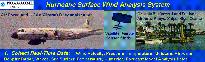
Method: As the hurricane approaches, reconnaissance aircraft, ships, buoys, and land stations gather measurements in real time (Figure 1). These winds are then standardized to a common exposure, height and averaging period based on documented methods; the role of modeling is limited to adjustments of flight-level aircraft measurements to the surface. Adjustment methods are subject to continuous verification involving independent comparisons with ground truth. The observations undergo interactive quality control before objective analysis. Once analyzed, the wind field is represented as streamlines and isotachs, which may be combined with radar reflectivity and high resolution geography (Figure 2). The analysis readily identifies locations that should expect the highest winds. The information is invaluable as input to damage assessment models, storm surge models, and geographic information systems where it can provide emergency managers with decision-making tools and guidance for planning response and recovery.
Accomplishment: During the 1995 and 1996 hurricane seasons, the surface wind analysis system was evaluated in an operational setting at the National Hurricane Center. In 1995, 86 real-time analyses were prepared, including the landfalls of Hurricanes Allison, Erin, and Opal in Florida, Luis, Marilyn, and Roxanne in the Caribbean, and the approach of Hurricane Felix to the U.S.east coast. In 1996 the total was 111, including landfalls of Hurricanes Bertha and Fran and Tropical Storm Josephine in the southeastern U.S. Work continues on automating the analysis, fine tuning the output to the forecasters' needs, developing new products for assessment of damage, and generating an archive of analyses to be made available on the world wide web. (This work was supported in part by a research Grant from Florida Power and Light Co.)
Key references:
Powell, M. D., S. H. Houston, and I. Ares, 1995: Real-time damage assessment in hurricanes.
21st Conference on Hurricanes and Tropical Meteorology, April 24-28, Miami, FL. American
Meteorological Society.
Powell, M. D., S. H. Houston, and T. Reinhold, 1996: Hurricane Andrew's landfall in south Florida. Part I: Standardizing measurements for documentation of surface wind fields. Weather and Forecasting, Sept. 1996.
Powell, M. D., and S. H. Houston, 1996: Hurricane Andrew's landfall in south Florida. Part II: Surface wind fields and potential real-time applications. Weather and Forecasting, Sept. 1996 .