NOAA/AOML - CARICOOS Underwater Gliders Successfully Monitor the different ocean conditions during the strongest 2017 Atlantic Hurricanes
NOAA/AOML completed three underwater glider missions in support of the 2017 Hurricane Field Program.
Two gliders operated in the Caribbean Sea, and one glider in the Tropical North Atlantic, both off Puerto Rico (panel A). Underwater gliders continually provided temperature and salinity profiles from July to November 2017 from areas where hurricanes commonly travel and intensify, totaling over 4,000 profiles of each parameter during the 2017 Hurricane Season. During the 2017 season, major Atlantic hurricanes travelled directly above, or very close to the location of the gliders, including hurricanes Maria, Jose, Irma (panel A). Ocean conditions before, during and after the passage of these tropical cyclones were monitored by NOAA/AOML gliders that included over 2,250 temperature and salinity profiles from 08/17/2017 to 09/30/2017 (Harvey to Maria). Together with glider observations, 30 XBT temperature profiles, 242 Argo temperature and salinity profiles, and surface temperature observations from 15 drifters were also available in the regions off Puerto Rico. Glider observations were continually transmitted in real-time and into the Global Telecommunications System (GTS) and used by operational forecast models.
Analysis of the ocean response to hurricanes winds based on these observations is currently underway. Preliminary results for Hurricane Irma show that one of the gliders was located in the area of maximum upper ocean cooling forced by the hurricane winds (panel B), with cooling anomalies sampled by the glider reaching values close to 1 o C (panel C), which is consistent with values reported for tropical cyclone induced cold wakes in the Atlantic. The immediate work also includes: (a) assessing the impact of assimilating glider observations within the HYbrid Coordinate Ocean Model (HYCOM); and (b) evaluating the impact of glider underwater observations in the hurricane intensity forecasts using the Hurricane Weather Research and Forecast ? HYCOM (HWRF-HYCOM) model. Scientists from NOAA/AOML, NOAA/EMC, CARICOOS, and Rutgers University are currently working together to explore opportunities to design and implement a sustained ocean observing system based on gliders in support of hurricane intensity forecasts. For more information, please visit the gliders website
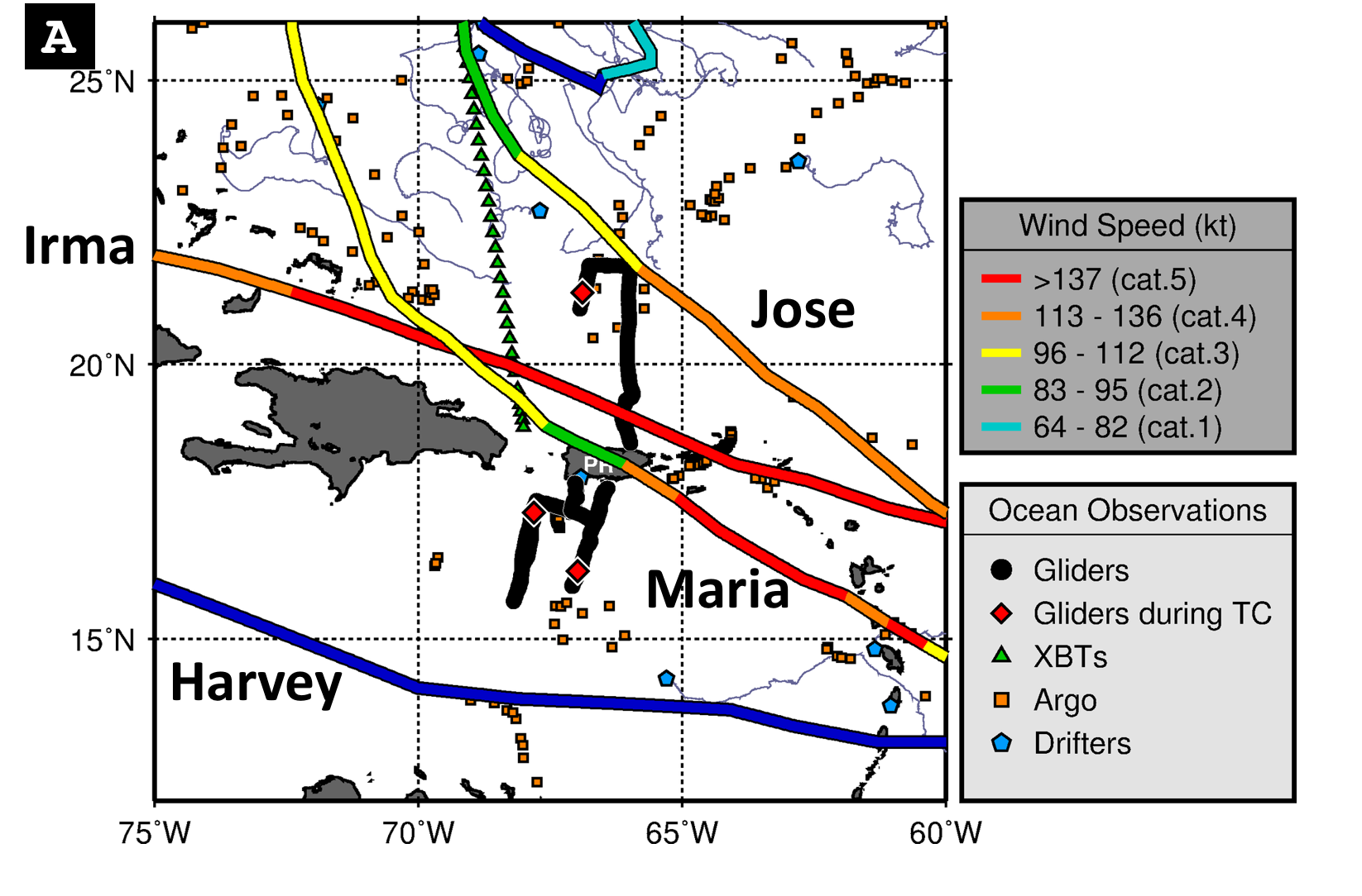
(A) Location of tropical cyclone tracks and ocean observations available for the period from 08/17/2017 to 09/30/2017, covering the time-frame from Hurricane Harvey and Hurricane Maria
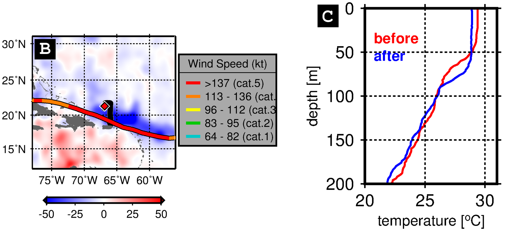
(B) Satellite-derived changes in the upper ocean heat content shown as the difference between conditions observed after the storm on 09/10/2017 minus conditions observed before the storm on 09/05/2017. (C) Subsurface the upper ocean temperature conditions sampled the glider before and after the passage of Irma.