Upper Ocean Observations during Tropical Storm Bertha (August, 2014)
In a joint effort between AOML, NDBC, the University of Miami, and the University of Puerto Rico Mayaguez, AOML deployed two underwater gliders off Puerto Rico, one in the Caribbean Sea and another one in the Atlantic Ocean, in mid July. These two gliders measure temperature and salinity profiles to 1000m 10 times a day and their data are transmitted in real-time into the GTS and distributed through AOML web pages. These gliders have already provided data from more than 500 profiles since their deployment. Late in July, the glider in the Caribbean Sea started surveying a cyclonic eddy. On August 2, 2014, while still surveying the eddy, this glider was located less than 100km from tropical storm Bertha, and able to keep providing ocean observations in real-time, which were incorporated in ocean models used to initialize operational tropical cyclone intensification models. Temperature and salinity section obtained during the first week of August is being used to assess the impact of the wind field in surface mixing and upper ocean dynamics in the Caribbean Sea. The goal of this two year-long project includes joint work with the NOAA Environmental Modeling Center and with the NOAA IOOS office to collect and distribute ocean data from similar events in order to assess the impact of upper ocean temperature and salinity observations in TC intensity forecasts.
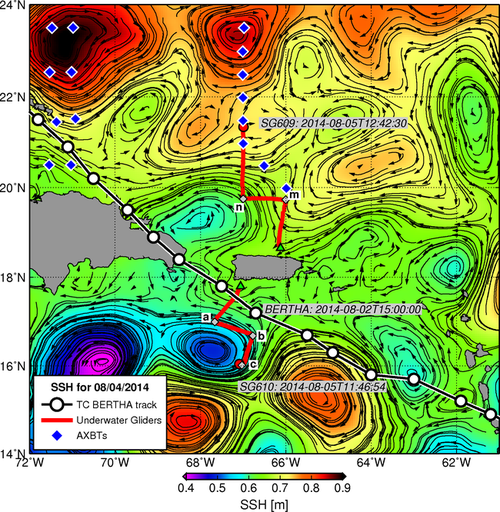
Figure. tracks of two AOML underwater gliders (red lines) deployed in mid July, track of tropical storm Bertha (black line, circles every 3hs intervals), and NOAA AXBT deployments (blue diamonds), superimposed to the altimetry-derived sea surface height (SSH) and geostrophic currents (arrows).
Underwater glider observations and research are made possible through funding from the Disaster Relief Appropriations Act of 2013, also known as the Sandy Supplemental.