

3.3 Interpretation of output fields from a Primitive Equations Model
The limitations of simulation 4 will be discussed in comparison with observations
and results from the Semtner/Chervin Parallel Ocean Climate Model (POCM;
Semtner_Chervin, 1992; Stammer et al., 1996). In the LPS model the inflowing
water is transported straight to the west. This is partly the cause of
the southward displacement of the subtropical gyre center and of the excessive
width of the westward current in the northern branch of the subtropical
gyre. It is well known from observations that the Benguela Current flows
along the African shelf before it turns westward between 30oS
and 25oS. If water reaches the South Atlantic via the Agulhas
leakage it will most probably be injected into the Benguela Current. This
source is thought to be of minor importance for the interoceanic exchange
in comparison with the role of the Agulhas rings (Lutjeharms and Van Ballegooyen,
1988). The rings can be observed between 40oS and 25oS.
They initially propagate in a northwesterly direction before they propagate
westward near 30oS (Gordon and Haxby, 1990; Garzoli et al..,
1999). Sometimes they were observed farther west than 40oW (Byrne
et al., 1995). The Agulhas rings in the output fields of the POCM (Fig.
19 ) are consistent with observations.
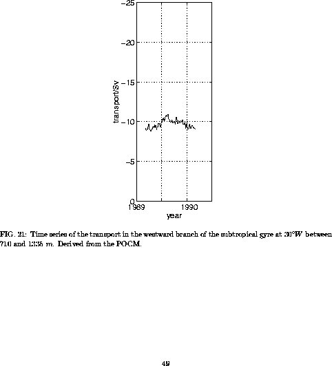
The transport in the subtropical gyre of the POCM is in good agreement
with observations (Fig. 20 ). There is no
significant transport deviation in the eastward current. The westward transports
are about 10% less than observed. The simulated gyre is only slightly south
of the observed gyre.
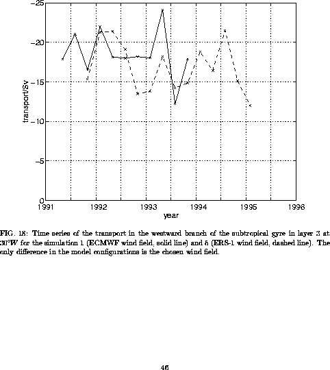
As expected the temporal variability of the POCM over one model year
is weaker than in simulations 1 and 5 of the LPS model (Figs. 18
and 21 ). At 30oW the seasonal
mean transports vary between 8 Sv and 11 Sv over the shown
year. While the simulations with the LPS model indicate that the minimum
of the westward transport mostly occurs in the second half of the year,
this does not seem to be the case in the POCM. The time series in Fig.
21 has a maximum in the second half of 1989, with
indications of two minima in the first half of the years 1989 and 1990.