|
Subject: A7) What is an extra-tropical cyclone ? Contributed by Stan Goldenberg (HRD)
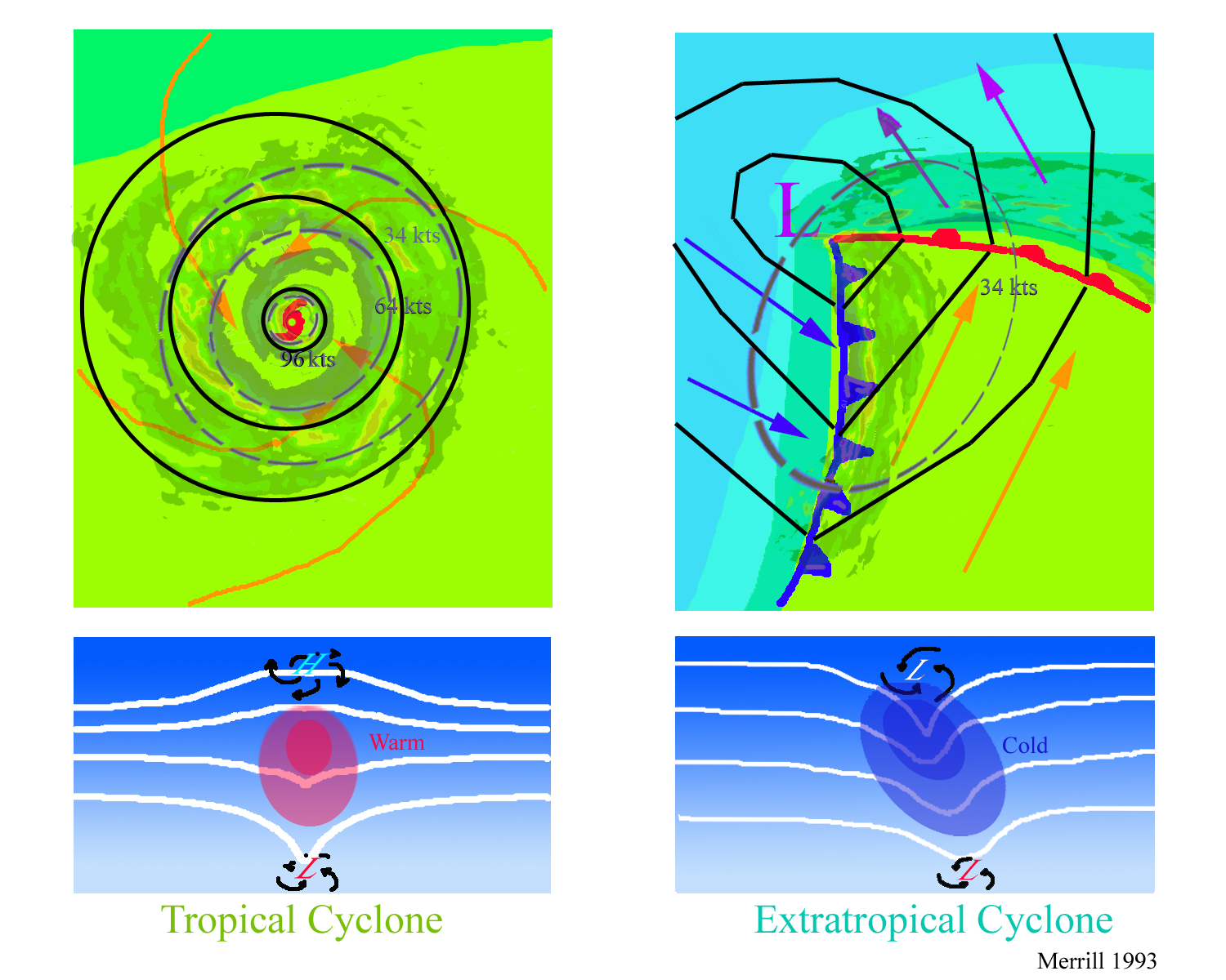
An extra-tropical cyclone is a storm system that primarily gets its energy from the horizontal temperature contrasts that exist in the atmosphere. Extra-tropical cyclones (also known as mid-latitude or baroclinic storms) are low pressure systems with associated cold fronts, warm fronts, and occluded fronts. Tropical cyclones, in contrast, typically have little to no temperature differences across the storm at the surface and their winds are derived from the release of energy due to cloud/rain formation from the warm moist air of the tropics ( Holland 1993, Merrill 1993).
Structurally, tropical cyclones have their strongest winds near the earth's surface , while extra-tropical cyclones have their strongest winds near the tropopause - about 8 miles (12 km) up. These differences are due to the tropical cyclone being "warm-core" in the troposphere (below the tropopause) and the extra-tropical cyclone being "warm-core" in the stratosphere (above the tropopause) and "cold-core" in the troposphere. "Warm-core" refers to being relatively warmer than the environment at the same pressure surface ("pressure surfaces" are simply another way to measure height or altitude). Often, a tropical cyclone will transform into an extra-tropical cyclone as it recurves poleward and to the east. Occassionally, an extra-tropical cyclone will lose its frontal features, develop convection near the center of the storm and transform into a full-fledged tropical cyclone. Such a process is most common in the North Atlantic and Northwest Pacific basins. The transformation of tropical cyclone into an extra-tropical cyclone (and vice versa) is currently one of the most challenging forecast problems (i.e., Jones et al. 2003).
References:
Merrill, R. T., (1993): "Tropical Cyclone Structure" - Chapter 2,
Global Guide to Tropical Cyclone Forecasting, WMO/TC-No. 560,
Report No. TCP-31, World Meteorological Organization; Geneva,
Switzerland
Last updated August 13, 2004
|
TC FAQ
Links of Interest
AOML Tools & Resources
Employee Tools
Stay Connected
|

| ||