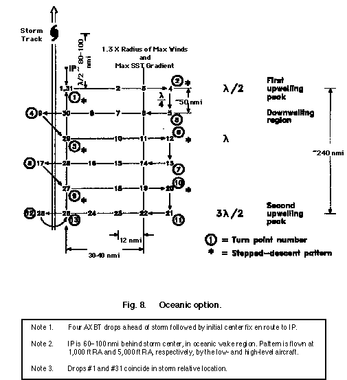
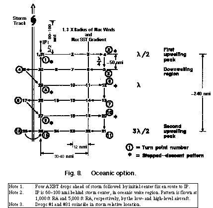
Option 2: Oceanic Processes
The oceanic option will be flown with two aircraft flying in "elephant line" formation, one behind the other. The lead aircraft will fly at 5,000 ft deploying AXCP's and minidrifting buoys ahead of and behind the storm along legs oriented at right angles
to the storm path as shown in Fig. 8. The second following aircraft will fly at a lower level measuring turbulent fluxes and deploying AXCP's or AXBT's at selected locations. Box patterns oriented along and across wind will be flown by both aircraft at
minibuoy locations to measure flux.
Option 3: Eastern Pacific PBL Processes
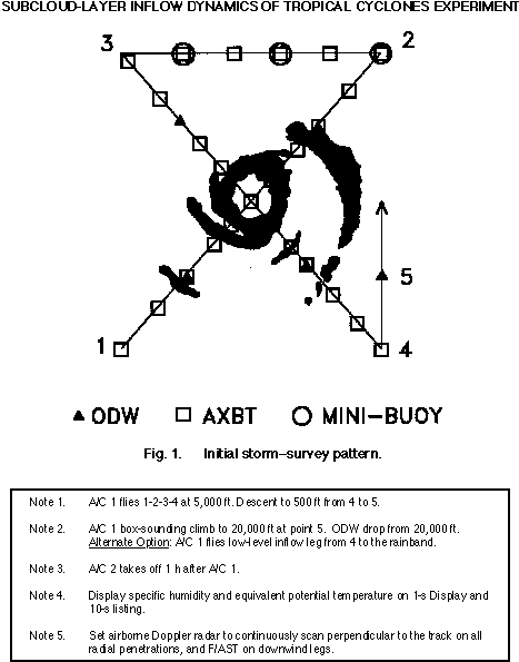
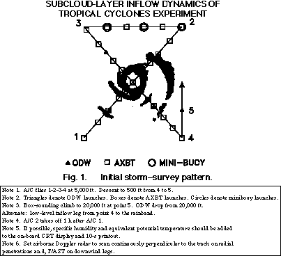
This option involves one aircraft that is equipped with the SFMR and C-SCAT deploying to La Paz on the Baja Peninsula and then flying a series of three missions into an EPAC hurricane beginning near the 26 C isotherm. Each flight involves a figure-4 patt
ern, similar to Fig. 1, flown at 5,000 ft and at 1,000 ft. AXBT's are to be dropped while at 5,000 ft.
The objective of the surface wind calibration option is to obtain in-situ surface wind measurements to compare with the airborne remote-sensing estimates of surface wind from the SFMR and C-SCAT. These comparisons need to be made under various air-sea tem
perature difference conditions and under various wave conditions (fully developed and fetch-limited).
Option 4: Remote Sensing
The remote sensing option is designed to obtain simultaneous surface directional wave spectra and surface wind speed and direction measurements. This experiment is best flown using the survey pattern in Fig. 1. The C-SCAT and SFMR aircraft are flown at
5000 ft., just behind the low-level aircraft, in trail formation. This pattern should be repeated a second time, but rotated 45 degrees.
A complement of 18 expendable probes on each aircraft is required to map SST. The low aircraft does the drops during the first figure-4 pattern, while the high aircraft drops ODWs; the high plane does the AXBT drops during the second figure-4.
Back to the Hurricane Field Program Experiment page.