Flight and scientific coordination will be important.
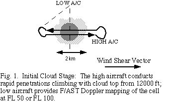
The high aircraft will make rapid repeated penetrations of the cloud, attempting to stay a fixed distance below the cloud top, sampling the microphysical and electric field development at a constant distance below the cloud top. The attempt will be to do cument the microphysics and electric field development near cloud top from first condensation through a mature cloud stage. At each pass through the cloud, vertical incidence Doppler data will be collected to document the evolution of the vertical velocit y field as the cloud matures. These patterns, or penetrations, will be oriented based upon the environmental wind shear vector. The high-level aircraft will release an Omega dropwindsonde (ODW) in the environment of each cloud sampled (in the clear, upwin d of the cloud). The times and locations of each ODW drop will be coordinated between aircraft.
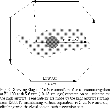
The second aircraft will fly near cloud base (~1 km), primarily documenting the kinematics of the cloud with in sit and Doppler radar data. The low-level aircraft will fly a circumnavigation pattern around each cloud, repeating the pattern until the high aircraft completes it's penetrations. During the circumnavigation the airborne Doppler radar will make observations covering the interior portion of the flight track to an altitude above cloud top. Emphasis will be placed on forward-aft scanning (FAST) o f the airborne Doppler radar on alternate sweeps to map the three-dimensional wind field. The FAST data will be collected in a sector mode, thereby doubling the along track resolution, as the aircraft circumnavigates the target cloud. This aircraft will a lso sample the boundary layer air flow, rainfall characteristics, the warm cloud microphysics, and photo-document the cloud behavior. The patterns will be repeated in each cloud sampled.
1. Miami to Barbados 1405 nm
2. One or more flights from Barbados involving down trajectory legs in the dust layer, with the emphasis on vertical profiles.
3. Barbados to Miami.
Flight legs are essentially direct, but along dust trajectories insofar as possible, with minor deviations for cloud penetrations and periodic vertical profiles. The vertical profiles would consist of an along track sounding from the flight level of 3 k m to the base of the dust layer (as low as 1.5 km), up to the top of the dust layer (~4.5 km), and back to flight level to sample the vertical profile of radiation, temperature, and aerosols through the dust layer. The location of the profiles will be sp ecified by the lead project scientist.