Effects of Synoptic Surveillance on model forecasts for
20 October 2005 0600 UTC
Wilma.
Quicktime movie of AVN DLM wind model
forecast
Quicktime movie of DLM wind data
increment
| TRACK (km) | ||||||||||||||||||||||||||||||||||||||||||||||||||||||||||||||||||||||||||||||||||||||||||||||||||||||||||||||||||||||||||||||||||||||||||||||||||||||||||||||||||||
| MODEL | 12 h | 24 h | 36 h | 48 h | 60 h | 72 h | 84 h | 96 h | 108 h | 120 h
| AVNN | 92 | 103 | 84 | 108 | 170 | 317 | 390 | 534 | 811 | 1054
| AVNO | 104 | 109 | 77 | 56 | 89 | 187 | 167 | 142 | 140 | 213
| %IMP | -13% | -6% | 8% | 48% | 48% | 41% | 57% | 73% | 83% | 80%
| GFNO | No forecast available
| GFDL | No forecast available
| %IMP |
| INTENSITY (kt)
| MODEL | 12 h | 24 h | 36 h | 48 h | 60 h | 72 h | 84 h | 96 h | 108 h | 120 h
| AVNN | -67 | -61 | -55 | -46 | -16 | -16 | -23 | -35 | -30 | -44
| AVNO | -54 | -55 | -59 | -49 | -27 | -20 | -25 | -36 | -27 | -37
| %IMP | r9% | 10% | -7% | -7% | -69% | -25% | -9% | -3% | -10% | -16%
| GFNO | No forecast available
| GFDL | No forecast available
| %IMP |
| | ||||||||||||||||||||||||||||||||||||||||||||||||||||||||||||||||
| 21/2145 UTC 20.6N 86.8W on Cozumel, Mexico, 39.75 h into the forecast | ||||||||||||||||||||||||||||||||||||||||||||||||||||||||||||||||||||||||||||||||||||||||||||||||||||||||||||||||||||||||||||||||||||||||||||
| MODEL | LAT | LON | TIME | ERROR | LOCATION
| AVNN | 20.56 | 86.77 | 28.0 | 5.4 | Punta Molas del Norte, Qintana Roo, Mexico
| AVNO | 20.49 | 87.24 | 32.0 | 47.4 | Playa del Carmen, Qintana Roo, Mexico
| %IMP | 34% | -678%
| GFNO | No forecast available
| GFDL | 20.56 | 86.75 | 27.0 | 6.8 | Punta Molas del Norte, Qintana Roo, Mexico
| %IMP |
|
22/0330 UTC 20.8N 86.9W near Puerto Morelos, Mexico 45.5 h into the forecast
| MODEL | LAT | LON | TIME | ERROR | LOCATION
| AVNN | 20.78 | 86.93 | 34.0 | 3.8 | Puerto Morelos, Qintana Roo, Mexico
| AVNO | 20.49 | 87.24 | 32.0 | 49.4 | Playa del Carmen, Qintana Roo, Mexico
| %IMP | -17% | -1200%
| GFNO | No forecast available
| GFDL | 20.84 | 86.87 | 29.5 | 5.4 | Puerto Morelos, Qintana Roo, Mexico
| %IMP |
|
24/1030 UTC 25.9N 81.7W near Cape Romano, FL 100.5 h into the forecast
| MODEL | LAT | LON | TIME | ERROR | LOCATION
| AVNN | 25.77 | 81.29 | 88.0 | 43.5 | Marco Island, FL
| AVNO | 25.65 | 81.20 | 98.0 | 57.2 | Chokoloskee, FL
| %IMP | 80% | -31%
| GFNO | No forecast available
| GFDL | 25.92 | 81.43 | 83.5 | 27.1 | Marco Island, FL
| %IMP |
| | ||||||||||||||||||||||||||||||||||||||||||||||
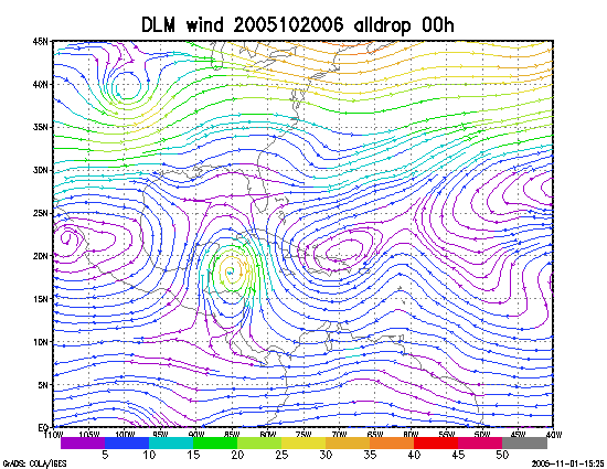
Figure 1. NCEP 850 - 200 hPa mean wind analysis for 20 October 2005 0600 UTC (Hurricane Wilma).
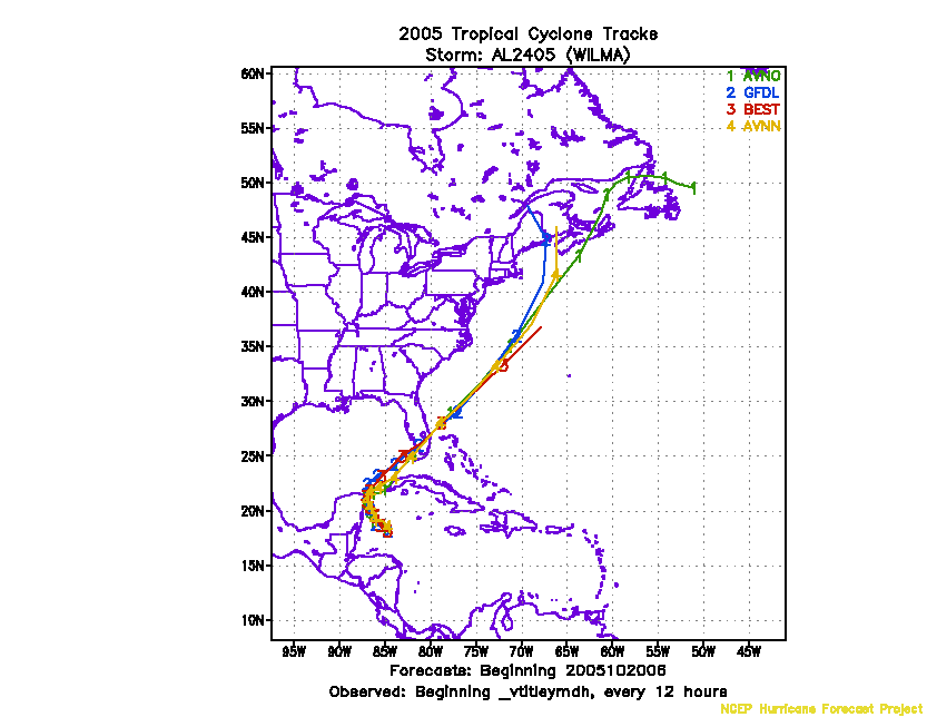
Figure 2. Track forecasts for the no dropwindsonde (NO or NN) and the all dropwindsonde (AL) runs for the AVN and GFDL models initialized on 20 October 2005 0600 UTC.
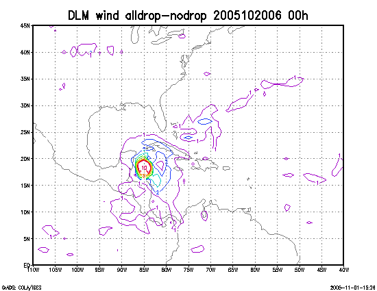
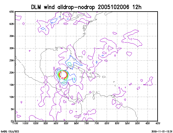
Figure 3. Initial condition differences in the 850 - 200 hPa mean wind between the no and all dropwindsonde cases for 20 October 2005 0600 UTC.