Effects of Synoptic Surveillance on model forecasts for
04 November 2001 0600 UTC
Michelle.
Quicktime movie of AVN DLM wind model forecast Quicktime movie of DLM wind data increment
| TRACK (km) | |||||||||||||||||||||||||||||||||||||||||||||||||||||||||||||||||||||||||||||||||||||||||||||||||||||||||||||||||||||||||||||||||||||||||||||||||||||||||||||||||||||||||||||||||||||||||||||||||||||||||||||||||||||||||||||||||||||
| MODEL | 12 h | 24 h | 36 h | 48 h | 60 h | 72 h | 84 h | 96 h | 108 h | 120 h
|
| AVNN | 141. | 192. | 9999. | 9999. | 9999. | 9999. | 9999. | 9999. | 9999. | 9999.
| AVAL | 127. | 126. | 9999. | 9999. | 9999. | 9999. | 9999. | 9999. | 9999. | 9999.
| %IMP | 10% | 34%
|
| GFNO | 121. | 131. | 283. | 418. | 565. | 9999. | 9999. | 9999. | 9999. | 9999.
| GFAL | 144. | 158. | 348. | 429. | 613. | 9999. | 9999. | 9999. | 9999. | 9999.
| %IMP | -19% | -21% | -23% | -3% | -8%
|
| VBNO | 94. | 189. | 318. | 281. | 240. | 9999. | 9999. | 9999. | 9999. | 9999.
| VBAL | 94. | 197. | 337. | 301. | 259. | 9999. | 9999. | 9999. | 9999. | 9999.
| %IMP | 0% | -4% | -6% | -7% | -8%
| INTENSITY (kt)
| MODEL | 12 h | 24 h | 36 h | 48 h | 60 h | 72 h | 84 h | 96 h | 108 h | 120 h
|
| AVNN | -80. | -43. | 9999. | 9999. | 9999. | 9999. | 9999. | 9999. | 9999. | 9999.
| AVAL | -68. | -33. | 9999. | 9999. | 9999. | 9999. | 9999. | 9999. | 9999. | 9999.
| %IMP | 15% | 23%
|
| GFNO | -9. | 19. | 36. | 25. | 36. | 9999. | 9999. | 9999. | 9999. | 9999.
| GFAL | -9. | 16. | 27. | 25. | 29. | 9999. | 9999. | 9999. | 9999. | 9999.
| %IMP | 0% | 16% | 25% | 0% | 19%
|
| SHNO | -8. | 12. | 3. | -16. | -13. | 9999. | 9999. | 9999. | 9999. | 9999.
| SHAL | -9. | 10. | 1. | -18. | -13. | 9999. | 9999. | 9999. | 9999. | 9999.
| %IMP | -13% | 17% | 67% | -13% | 0%
|
| DSNO | -8. | -9. | -18. | -37. | -33. | 9999. | 9999. | 9999. | 9999. | 9999.
| DSAL | -9. | -10. | -19. | -38. | -33. | 9999. | 9999. | 9999. | 9999. | 9999.
| %IMP | -13% | 17% | -6% | -3% | 0%
| | ||||||||||
04/1800UTC 21.5N 81.8W Cayo Largo, Cuba 12 h into forecast
| MODEL | LAT | LON | TIME | ERROR | LOCATION
|
| AVNN | 21.46 | 82.46 | 17.0 | 68.4 | Isla de la Juventud, Cuba
| AVAL | 21.23 | 81.12 | 19.0 | 76.5 | Approach to Cayo Largo, Cuba
| %IMP | -40% | -12%
|
| GFNO | 21.62 | 81.57 | 19.0 | 27.2 | Cayo Largo, Cuba
| GFAL | 21.71 | 81.70 | 19.5 | 25.5 | Cayo Largo, Cuba
| %IMP | -7% | 6%
|
| VBNO | 21.48 | 82.42 | 14.5 | 64.1 | Isla de la Juventud, Cuba
| VBAL | 21.51 | 82.44 | 14.5 | 66.2 | Isla de la Juventud, Cuba
| %IMP | 0% | -3%
|
|
| 04/2300UTC 22.1N 81.2W at Bahia de Cochinos, Cuba 17 h into forecast
| MODEL | LAT | LON | TIME | ERROR | LOCATION
|
| AVNN | Tracker lost center
| AVAL | 21.82 | 80.23 | 23.0 | 104.7 | Near Cienfuegos, Cienfuegos, Cuba
| %IMP
|
| GFNO | 22.12 | 81.10 | 22.0 | 10.5 | Bahia de Cochinos, Matanzas, Cuba
| GFAL | 22.13 | 81.35 | 22.0 | 15.8 | Bahia de Cochinos, Matanzas, Cuba
| %IMP | 0% | -50%
|
| VBNO | 22.49 | 81.68 | 22.5 | 65.7 | Near Bahia de Cochinos, Matanzas, Cuba
| VBAL | 22.66 | 81.71 | 23.0 | 81.3 | Near Surgidero de Batabano, Habana, Cuba
| %IMP | -9% | -24%
|
|
| 05/1200UTC 24.3N 78.0W at Andros Island, Bahamas 30 h into forecast
| MODEL | LAT | LON | TIME | ERROR | LOCATION
|
|
| AVNN | Tracker lost center
| AVAL | 23.98 | 77.84 | 32.5 | 39.1 | Southern Bight, Andros Island, Bahamas
| %IMP
|
| GFNO | 25.66 | 78.59 | 40.0 | 162.4 | Approach to Nicholls' Town, Andros Island, Bahamas
| GFAL | 25.66 | 78.57 | 42.0 | 161.6 | Approach to Nicholls' Town, Andros Island, Bahamas
| %IMP | -20% | 0%
|
| VBNO | 25.23 | 78.17 | 40.5 | 104.7 | Nicholls' Town, Andros Island, Bahamas
| VBAL | 25.30 | 78.23 | 41.0 | 113.5 | Nicholls' Town, Andros Island, Bahamas
| %IMP | -5% | -8%
|
|
| 05/1800UTC 25.4N 76.4W at Eleuthera Island, Bahamas 36 h into forecast
| MODEL | LAT | LON | TIME | ERROR | LOCATION
|
| AVNN | Tracker lost center
| AVAL | 25.29 | 76.32 | 37.5 | 14.6 | James Cistern, Eleuthera, Bahamas
| %IMP |
|
| GFNO | 26.39 | 77.21 | 46.5 | 136.6 | The Marls, Abaco Island, Bahamas
| GFAL | 26.42 | 77.05 | 47.5 | 130.6 | Snake City, Abaco Island, Bahamas
| %IMP | -10% | 4%
|
| VBNO | 25.73 | 77.18 | 43.5 | 86.3 | Southwest Point, Abaco Island, Bahamas
| VBAL | 25.80 | 77.21 | 44.0 | 92.5 | Southwest Point, Abaco Island, Bahamas
| %IMP | -7% | -7%
| | |||||||||||||||||||||||||||||||||||||||||||||||||||||||||||||||||
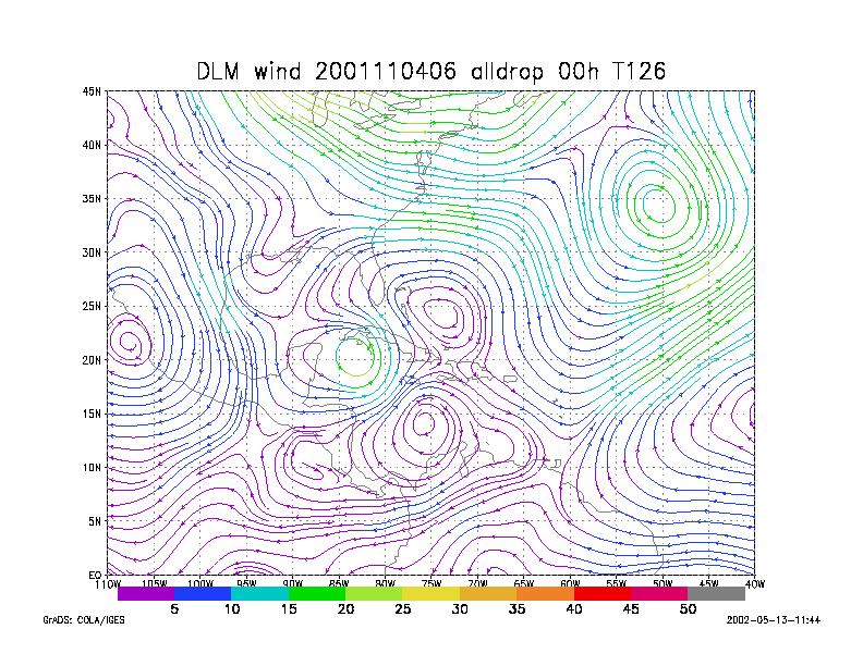
Figure 1.
NCEP 850 - 200 hPa mean wind analysis for 04 November 2001 0600 UTC
Tropical Depression #15.
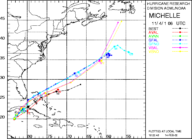
Figure 2. Track forecasts for the no dropwindsonde (NO or NN) and the all dropwindsonde (AL) runs for the AVN, GFDL, and VBAR models initialized on 04 November 2001 0600 UTC. The best track is shown in black.
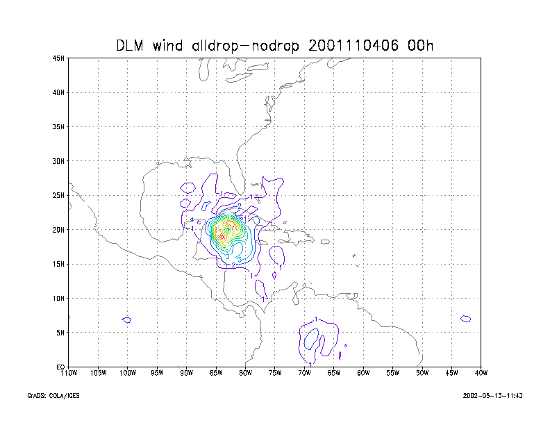
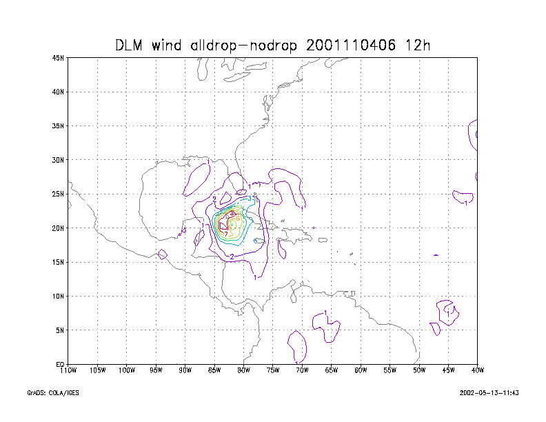
Figure 3.
Initial condition differences in the 850 - 200 hPa mean wind between the
no and all dropwindsonde cases
for 04 November 2001 0600 UTC.