Effects of Synoptic Surveillance on model forecasts for
04 November 2001 0000 UTC
Michelle.
Quicktime movie of AVN DLM wind model forecast Quicktime movie of DLM wind data increment
| TRACK (km) | |||||||||||||||||||||||||||||||||||||||||||||||||||||||||||||||||||||||||||||||||||||||||||||||||||||||||||||||||||||||||||||||||||||||||||||||||||||||||||||||||||||||||||||||||||||||||||||||||||||||||||||||||||||||||||||||||||
| MODEL | 12 h | 24 h | 36 h | 48 h | 60 h | 72 h | 84 h | 96 h | 108 h | 120 h
|
| AVNN | 123. | 9999. | 9999. | 9999. | 9999. | 9999. | 9999. | 9999. | 9999. | 9999.
| AVAL | 165. | 9999. | 9999. | 9999. | 9999. | 9999. | 9999. | 9999. | 9999. | 9999.
| %IMP | -34%
|
| GFNO | 119. | 186. | 425. | 679. | 1012. | 9999. | 9999. | 9999. | 9999. | 9999.
| GFAL | 99. | 144. | 334. | 564. | 858. | 9999. | 9999. | 9999. | 9999. | 9999.
| %IMP | 17% | 23% | 21% | 17% | 15%
|
| VBNO | 125. | 257. | 438. | 531. | 571. | 9999. | 9999. | 9999. | 9999. | 9999.
| VBAL | 126. | 257. | 416. | 485. | 496. | 9999. | 9999. | 9999. | 9999. | 9999.
| %IMP | -1% | 0% | 5% | 9% | 13%
| INTENSITY (kt)
| MODEL | 12 h | 24 h | 36 h | 48 h | 60 h | 72 h | 84 h | 96 h | 108 h | 120 h
|
| AVNN | -88. | 9999. | 9999. | 9999. | 9999. | 9999. | 9999. | 9999. | 9999. | 9999.
| AVAL | -72. | 9999. | 9999. | 9999. | 9999. | 9999. | 9999. | 9999. | 9999. | 9999.
| %IMP | 18%
|
| GFNO | -11. | -10. | 22. | 4. | 17. | 9999. | 9999. | 9999. | 9999. | 9999.
| GFAL | -5. | 4. | 27. | 12. | 9. | 9999. | 9999. | 9999. | 9999. | 9999.
| %IMP | 55% | 60% | -23% | -100% | 47%
|
| SHNO | -12. | -9. | 2. | -9. | -19. | 9999. | 9999. | 9999. | 9999. | 9999.
| SHAL | -12. | -11. | 0. | -10. | -20. | 9999. | 9999. | 9999. | 9999. | 9999.
| %IMP | 0% | -22% | 100% | -11% | -5%
|
| DSNO | -12. | -23. | -18. | 9999. | -38. | 9999. | 9999. | 9999. | 9999. | 9999.
| DSAL | -12. | -24. | -19. | 9999. | -39. | 9999. | 9999. | 9999. | 9999. | 9999.
| %IMP | 0% | -4% | -5% | -3%
| | |||||||||||
04/1800UTC 21.5N 81.8W Cayo Largo, Cuba 18 h into forecast
| MODEL | LAT | LON | TIME | ERROR | LOCATION
|
| AVNN | 21.33 | 82.26 | 25.0 | 56.3 | Isla de la Juventud, Cuba
| AVAL | Tracker lost center
| %IMP
|
| GFNO | 21.43 | 82.93 | 19.5 | 117.1 | Punta del Guanal, Isla de la Juventud, Cuba
| GFAL | 21.52 | 82.65 | 19.5 | 87.9 | Isla de la Juventud, Cuba
| %IMP | 0% | 25%
|
| VBNO | 22.30 | 83.30 | 24.0 | 178.3 | Playa Dayaniguas, Pinar del Rio, Cuba
| VBAL | 22.17 | 83.43 | 21.5 | 183.8 | Near Playa Dayaniguas, Pinar del Rio, Cuba
| %IMP | 42% | -3%
|
|
| 04/2300UTC 22.1N 81.2W at Bahia de Cochinos, Cuba 23 h into forecast
| MODEL | LAT | LON | TIME | ERROR | LOCATION
|
| AVNN | 22.30 | 81.23 | 31.0 | 22.4
| AVAL | Tracker lost center
| %IMP
|
| GFNO | 22.69 | 82.49 | 26.5 | 147.8 | Guira de Melena, Habana, Cuba
| GFAL | 22.68 | 82.03 | 26.0 | 106.9 | Surgidero de Batabano, Habana, Cuba
| %IMP |
|
| VBNO | 22.30 | 83.30 | 24.0 | 217.2 | Playa Dayaniguas, Pinar del Rio, Cuba
| VBAL | 22.17 | 83.43 | 21.5 | 229.6 | Near Playa Dayaniguas, Pinar del Rio, Cuba
| %IMP | -50% | -6%
|
|
| 05/1200UTC 24.3N 78.0W at Andros Island, Bahamas 36 h into forecast
| MODEL | LAT | LON | TIME | ERROR | LOCATION
|
|
| AVNN | Tracker lost center
| AVAL | Tracker lost center
| %IMP
|
| GFNO | 25.35 | 81.14 | 48.5 | 337.4 | Ponce de Leon Bay, FL
| GFAL | 24.70 | 81.18 | 37.5 | 324.5 | Marathon, FL
| %IMP | 88% | 4%
|
| VBNO | 24.70 | 81.11 | 42.5 | 317.5 | Marathon, FL
| VBAL | 24.63 | 81.37 | 40.0 | 344.0 | Big Pine Key, FL
| %IMP | 38% | -8%
|
|
| 05/1800UTC 25.4N 76.4W at Eleuthera Island, Bahamas 42 h into forecast
| MODEL | LAT | LON | TIME | ERROR | LOCATION
|
| AVNN | Tracker lost center
| AVAL | Tracker lost center
| %IMP |
|
| GFNO | 28.48 | 79.60 | 85.5 | 466.4 | Approach Cape Canaveral, FL
| GFAL | 26.60 | 77.88 | 63.0 | 199.0 | Sweetings Cay, Grand Bahama Island, Bahamas
| %IMP | 52% | 57%
|
| VBNO | 25.98 | 77.40 | 55.0 | 119.1 | Sandy Point, Abaco Island, Bahamas
| VBAL | 26.21 | 77.23 | 54.0 | 122.4 | Crossing Rocks, Abaco Island, Bahamas
| %IMP | 8% | -3%
| | |||||||||||||||||||||||||||||||||||||||||||||||||||||||||||||||||||||||||
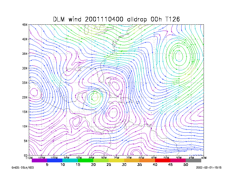
Figure 1.
NCEP 850 - 200 hPa mean wind analysis for 04 November 2001 0000 UTC
Tropical Depression #15.
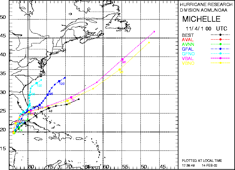
Figure 2. Track forecasts for the no dropwindsonde (NO or NN) and the all dropwindsonde (AL) runs for the AVN, GFDL, and VBAR models initialized on 04 November 2001 0000 UTC. The best track is shown in black.
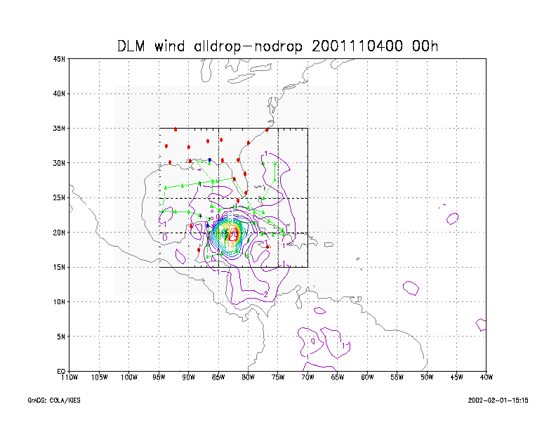
Figure 3.
Initial condition differences in the 850 - 200 hPa mean wind between the
no and all dropwindsonde cases
for 04 November 2001 0000 UTC.