Effects of Synoptic Surveillance on model forecasts for
03 November 2001 0000 UTC
Michelle.
Quicktime movie of AVN DLM wind model forecast Quicktime movie of DLM wind data increment
| TRACK (km) | |||||||||||||||||||||||||||||||||||||||||||||||||||||||||||||||||||||||||||||||||||||||||||||||||||||||||||||||||||||||||||||||||||||||||||||||||||||||||||||||||||||||||||||||||||||||||||||||||||||||||||||||||||||||||||||||||||||||||||||||||||||
| MODEL | 12 h | 24 h | 36 h | 48 h | 60 h | 72 h | 84 h | 96 h | 108 h | 120 h
|
| AVNN | 32. | 42. | 146. | 183. | 151. | 9999. | 9999. | 9999. | 9999. | 9999.
| AVAL | 95. | 22. | 0. | 39. | 33. | 9999. | 9999. | 9999. | 9999. | 9999.
| %IMP | -197% | 48% | 100% | 79% | 78%
|
| GFNO | 32. | 147. | 291. | 443. | 642. | 809. | 1124. | 9999. | 9999. | 9999.
| GFAL | 39. | 139. | 253. | 390. | 573. | 789. | 1085. | 9999. | 9999. | 9999.
| %IMP | -22% | 5% | 13% | 12% | 11% | 2% | 3%
|
| VBNO | 39. | 169. | 364. | 570. | 801. | 984. | 1130. | 9999. | 9999. | 9999.
| VBAL | 35. | 146. | 327. | 513. | 738. | 912. | 1046. | 9999. | 9999. | 9999.
| %IMP | 10% | 14% | 10% | 10% | 8% | 7% | 7%
| INTENSITY (kt)
| MODEL | 12 h | 24 h | 36 h | 48 h | 60 h | 72 h | 84 h | 96 h | 108 h | 120 h
|
| AVNN | -86. | -85. | -85. | -66. | -42. | 9999. | 9999. | 9999. | 9999. | 9999.
| AVAL | -71. | -64. | -68. | -51. | -23. | 9999. | 9999. | 9999. | 9999. | 9999.
| %IMP | 17% | 25% | 20% | 23% | 45%
|
| GFNO | -5. | 1. | -11. | -3. | 12. | 13. | 21. | 9999. | 9999. | 9999.
| GFAL | -1. | -2. | -14. | 3. | 19. | 9. | 16. | 9999. | 9999. | 9999.
| %IMP | 80% | -100% | -27% | 0% | -58% | 31% | 24%
|
| SHNO | -19. | -16. | -25. | -17. | -4. | -11. | -11. | 9999. | 9999. | 9999.
| SHAL | -20. | -17. | -25. | -16. | -3. | -9. | -9. | 9999. | 9999. | 9999.
| %IMP | -5% | -6% | 0% | 6% | 25% | 18% | 18%
|
| DSNO | -19. | -16. | -25. | -30. | -22. | -29. | -29. | 9999. | 9999. | 9999.
| DSAL | -20. | -17. | -25. | -29. | -21. | -27. | -27. | 9999. | 9999. | 9999.
| %IMP | -5% | -6% | 0% | 3% | 5% | 7% | 7%
| | ||||||||||
04/1800UTC 21.5N 81.8W Cayo Largo, Cuba 42 h into forecast
| MODEL | LAT | LON | TIME | ERROR | LOCATION
|
| AVNN | 21.57 | 83.00 | 45.0 | 124.3 | Isla de la Juventud, Cuba
| AVAL | 21.66 | 81.61 | 42.0 | 26.5 | Cayo Largo, Cuba
| %IMP | 100% | 79%
|
| GFNO | 21.95 | 85.15 | 46.5 | 349.3 | Near Cabo Frances, Pinar del Rio, Cuba
| GFAL | 21.86 | 84.74 | 45.0 | 306.2 | Near Cabo Frances, Pinar del Rio, Cuba
| %IMP | 33% | 12%
|
| VBNO | 22.35 | 84.37 | 67.0 | 281.2 | Near Santa Lucia, Pinar del Rio, Cuba
| VBAL | 21.70 | 84.40 | 61.5 | 269.5 | Near Cabo Frances, Pinar del Rio, Cuba
| %IMP | 22% | 4%
|
| 04/2300UTC 22.1N 81.2W at Bahia de Cochinos, Cuba 47 h into forecast
| MODEL | LAT | LON | TIME | ERROR | LOCATION
|
| AVNN | 22.25 | 81.88 | 51.0 | 71.9 | Near Bahia de Cochinos, Matanzas, Cuba
| AVAL | 22.08 | 81.21 | 44.5 | 2.4 | Bahia de Cochinos, Matanzas, Cuba
| %IMP | 38% | 97%
|
| GFNO | 22.83 | 84.56 | 56.5 | 354.4
| GFAL | 22.43 | 84.54 | 49.0 | 345.4
| %IMP | 79% | 3%
|
| VBNO | 22.35 | 84.37 | 67.0 | 327.2 | Near Santa Lucia, Pinar del Rio, Cuba
| VBAL | 22.66 | 82.05 | 74.0 | 107.2 | Surgidero de Batabano, Habana, Cuba
| %IMP | -35% | 67%
|
| 05/1200UTC 24.3N 78.0W at Andros Island, Bahamas 60 h into forecast
| MODEL | LAT | LON | TIME | ERROR | LOCATION
|
|
| AVNN | Tracker lost center
| AVAL | 24.48 | 78.25 | 59.0 | 32.2 | Middle Bight, Andros Island, Bahamas
| %IMP
|
| GFNO | 26.30 | 81.79 | 77.5 | 440.8 | Naples Park, FL
| GFAL | 25.99 | 81.67 | 76.5 | 414.1 | Marco Island, FL
| %IMP | 6% | 6%
|
| VBNO | 24.26 | 78.04 | 90.0 | 6.0 | Middle Bight, Andros Island, Bahamas
| VBAL | 24.12 | 77.92 | 88.0 | 21.6 | Middle Bight, Andros Island, Bahamas
| %IMP | 7% | -260%
|
| 05/1800UTC 25.4N 76.4W at Eleuthera Island, Bahamas 66 h into forecast
| MODEL | LAT | LON | TIME | ERROR | LOCATION
|
| AVNN | Tracker lost center
| AVAL | Tracker lost center
| %IMP |
|
| GFNO | 30.83 | 79.62 | 107.5 | 680.8 | Approach to St. Simons, GA
| GFAL | 31.80 | 79.20 | 120.0 | 761.7 | Approach to Cape Fear, NC
| %IMP | -30% | -12%
|
| VBNO | 24.88 | 76.17 | 94.5 | 62.2 | Rock Sound, Eleuthera, Bahamas
| VBAL | 24.80 | 76.15 | 92.5 | 71.2 | Rock Sound, Eleuthera, Bahamas
| %IMP | 7% | -14%
| | ||||||||||||||||||||||||||||||||||||||||||||||||||||
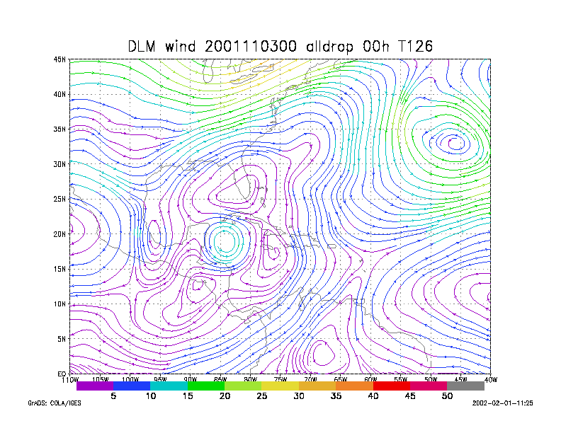
Figure 1.
NCEP 850 - 200 hPa mean wind analysis for 03 November 2001 0000 UTC
Tropical Depression #15.
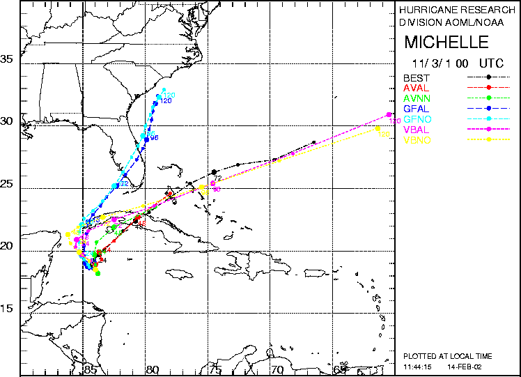
Figure 2. Track forecasts for the no dropwindsonde (NO or NN) and the all dropwindsonde (AL) runs for the AVN, GFDL, and VBAR models initialized on 03 November 2001 0000 UTC. The best track is shown in black.
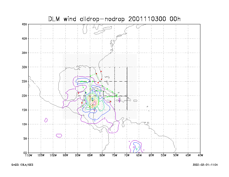
Figure 3.
Initial condition differences in the 850 - 200 hPa mean wind between the
no and all dropwindsonde cases
for 03 November 2001 0000 UTC.