Effects of Synoptic Surveillance on model forecasts for
01 November 2001 1200 UTC
Michelle.
Quicktime movie of AVN DLM wind model forecast Quicktime movie of DLM wind data increment
| TRACK (km) | ||||||||||||||||||||||||||||||||||||||||||||||||||||||||||||||||||||||||||||||||||||||||||||||||||||||||||||||||||||||||||||||||||||||||||||||||||||||||||||||||||||||||||||||||||||||||||||||||||||||||||||||||||||||||||||||||||||||||||||||||||||||||||||||||||||||||||||||
| MODEL | 12 h | 24 h | 36 h | 48 h | 60 h | 72 h | 84 h | 96 h | 108 h | 120 h
|
| AVNN | 48. | 21. | 92. | 98. | 130. | 166. | 227. | 342. | 334. | 273.
| AVAL | 67. | 44. | 63. | 54. | 86. | 174. | 258. | 406. | 436. | 387.
| %IMP | -40% | -110% | 32% | 45% | 34% | -5% | -14% | -19% | -31% | -42%
|
| GFNO | 69. | 123. | 152. | 197. | 321. | 497. | 618. | 796. | 987. | 1163.
| GFAL | 101. | 192. | 283. | 325. | 432. | 511. | 615. | 840. | 1001. | 1134.
| %IMP | -46% | -56% | -86% | -65% | -35% | -3% | 0% | -6% | -1% | 2%
|
| VBNO | 116. | 260. | 378. | 469. | 559. | 657. | 728. | 836. | 908. | 929.
| VBAL | 107. | 253. | 378. | 477. | 565. | 654. | 729. | 848. | 927. | 958.
| %IMP | 8% | 3% | 0% | -2% | -1% | 0% | 0% | -1% | -2% | -3%
| INTENSITY (kt)
| MODEL | 12 h | 24 h | 36 h | 48 h | 60 h | 72 h | 84 h | 96 h | 108 h | 120 h
|
| AVNN | -32. | -47. | -66. | -90. | -87. | -91. | -73. | -46. | -35. | -20.
| AVAL | -31. | -45. | -65. | -88. | -87. | -89. | -72. | -41. | -33. | -15.
| %IMP | 3% | 4% | 2% | 2% | 0% | 2% | 1% | 11% | 6% | 25%
|
| GFNO | 7. | -10. | -13. | -31. | -31. | -32. | -15. | 27. | 26. | 15.
| GFAL | 12. | -6. | -21. | -52. | -56. | -55. | -24. | 18. | 20. | 31.
| %IMP | -71% | 40% | -62% | -68% | -81% | -72% | -60% | 33% | 23% | -107%
|
| SHNO | 14. | 9. | -3. | -21. | -20. | -28. | -15. | 6. | 7. | 16.
| SHAL | 14. | 10. | -2. | -21. | -19. | -27. | -15. | 6. | 7. | 16.
| %IMP | 0% | -11% | 33% | 0% | 5% | 4% | 0% | 0% | 0% | 0%
|
| DSNO | 14. | 9. | -3. | -21. | -20. | -42. | -26. | -24. | -33. | -24.
| DSAL | 14. | 10. | -2. | -21. | -19. | -41. | -26. | -24. | -33. | -24.
| %IMP | 0% | -11% | 33% | 0% | 5% | 2% | 0% | 0% | 0% | 0%
| | ||||||||||
04/1800UTC 21.5N 81.8W Cayo Largo, Cuba 78 h into forecast
| MODEL | LAT | LON | TIME | ERROR | LOCATION
|
| AVNN | 21.36 | 81.42 | 90.0 | 42.3 | Approach to Cayo Largo, Cuba
| AVAL | 20.86 | 81.39 | 90.0 | 82.8 | Approach to Cayo Largo, Cuba
| %IMP | 0% | -96%
|
| GFNO | 20.55 | 86.96 | 79.0 | 545.4 | Approach to Isla Cozumel, Quintana Roo, Mexico
| GFAL | 21.48 | 82.52 | 109.0 | 74.5 | La Isla de la Juventud, Cuba
| %IMP | -2000% | 86%
|
| VBNO | 20.31 | 86.91 | 35.0 | 546.6 | Isla Cozumel, Quintana Roo, Mexico, Cuba
| VBAL | 20.31 | 86.91 | 35.0 | 320.5 | Isla Cozumel, Quintana Roo, Mexico, Cuba
| %IMP | 0% | 0%
| 04/2300UTC 22.1N 81.2W at Bahia de Cochinos, Cuba 83 h into forecast
| MODEL | LAT | LON | TIME | ERROR | LOCATION
|
| AVNN | 21.84 | 80.22 | 95.5 | 105.0 | Near Cienfuegos, Cienfuegos, Cuba
| AVAL | 21.55 | 79.41 | 99.0 | 194.5 | Near Tunas de Zaza, Spiritus Sancti, Cuba
| %IMP | -28% | -85%
|
| GFNO | 22.40 | 85.39 | 97.0 | 432.1 | Cabo de S. Antonio, Pinar del Rio, Cuba
| GFAL | 22.18 | 81.73 | 113.0 | 55.3 | Near Bahia de Cochinos, Matanzas, Cuba
| %IMP | -43% | 87%
|
| VBNO | 23.49 | 84.25 | 104.0 | 348.5 | Near Santa Lucia, Pinar del Rio, Cuba
| VBAL | 23.49 | 84.28 | 104.5 | 351.2 | Near Santa Lucia, Pinar del Rio, Cuba
| %IMP | -2% | -1%
| 05/1200UTC 24.3N 78.0W at Andros Island, Bahamas 96 h into forecast
| MODEL | LAT | LON | TIME | ERROR | LOCATION
|
|
| AVNN | 23.45 | 77.37 | 105.5 | 114.1 | Cistern Point, Andros Island, Bahamas
| AVAL | 23.65 | 76.03 | 111.0 | 212.6 | Rolleville, Great Exuma, Bahamas
| %IMP | -35% | -86%
|
| GFNO | 26.80 | 81.20 | 117.0 | 403.0
| GFAL | 23.30 | 80.10 | 120.0 | 240.6
| %IMP | -11% | 40%
|
| VBNO | 24.43 | 80.90 | 114.5 | 293.8 | Marathon, FL
| VBAL | 24.52 | 80.97 | 115.0 | 301.5 | Marathon, FL
| %IMP | -2% | -3%
| 05/1800UTC 25.4N 76.4W at Eleuthera Island, Bahamas 102 h into forecast
| MODEL | LAT | LON | TIME | ERROR | LOCATION
|
| AVNN | 24.32 | 75.56 | 110.5 | 146.9 | New Bight, Cat Island, Bahamas
| AVAL | 24.06 | 75.14 | 113.5 | 195.8 | Port Howe, Cat Island, Bahamas
| %IMP | 0% | -33%
|
| GFNO | 25.40 | 81.20 | 120.0 | 481.7
| GFAL | 23.30 | 80.10 | 120.0 | 441.2
| %IMP | 0% | 8%
|
| VBNO | 25.10 | 78.70 | 120.0 | 233.5
| VBAL | 25.10 | 79.00 | 120.0 | 263.4
| %IMP | 0% | -13%
| | ||||||||||||||||||||||||||||||||||||||||||||
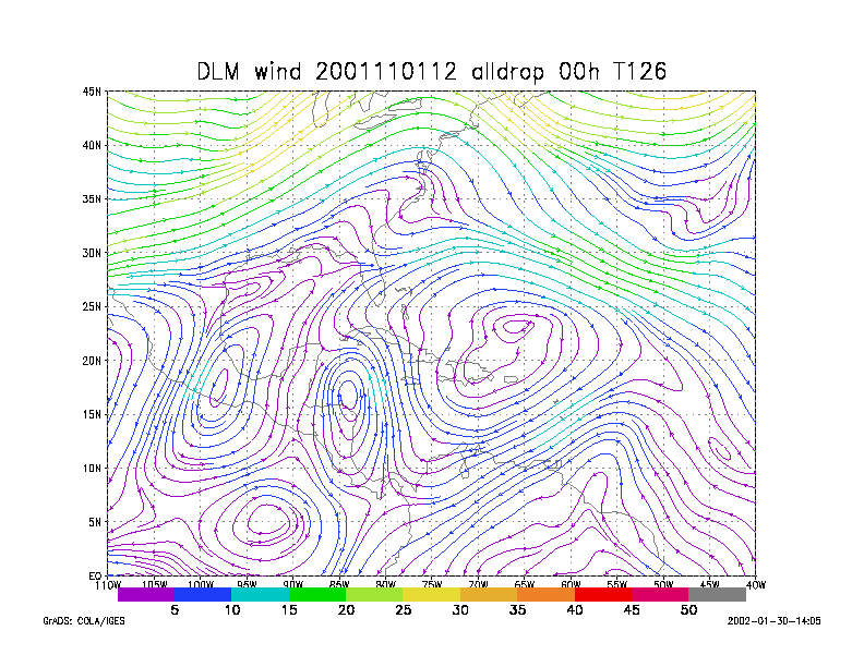
Figure 1.
NCEP 850 - 200 hPa mean wind analysis for 01 November 2001 1200 UTC
Tropical Depression #15.
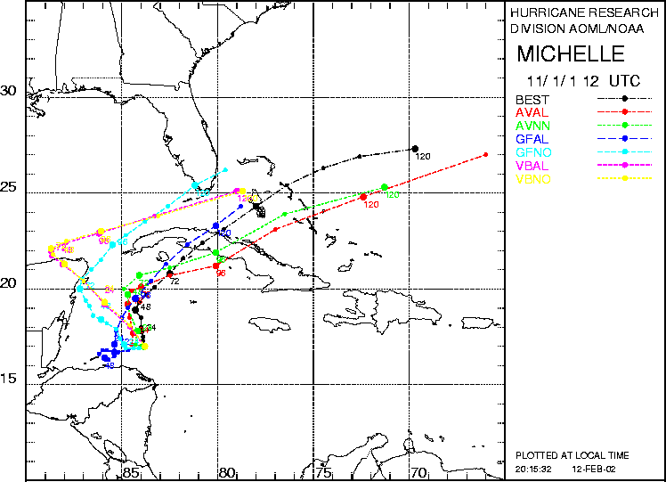
Figure 2. Track forecasts for the no dropwindsonde (NO or NN) and the all dropwindsonde (AL) runs for the AVN, GFDL, and VBAR models initialized on 01 November 2001 1200 UTC. The best track is shown in black.
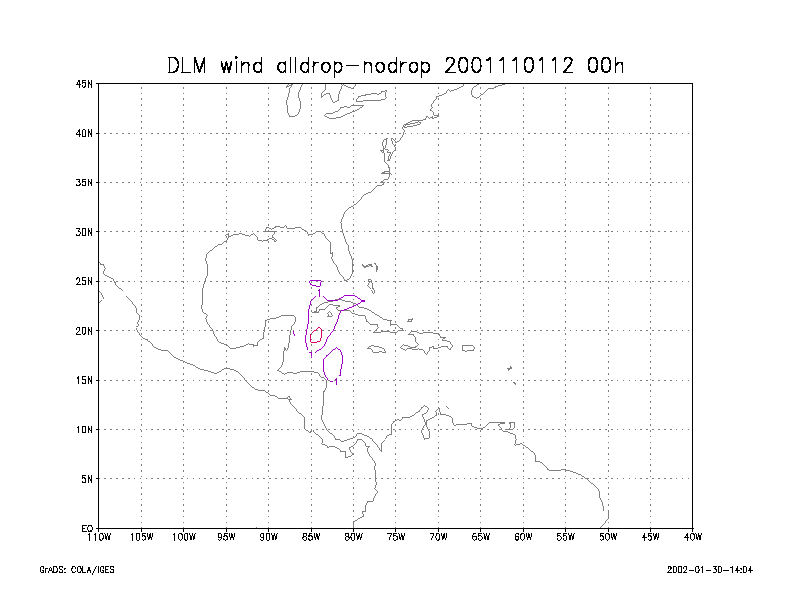
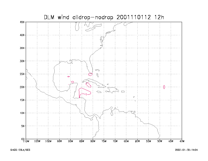
Figure 3.
Initial condition differences in the 850 - 200 hPa mean wind between the
no and all dropwindsonde cases
for 01 November 2001 1200 UTC.