Effects of Synoptic Surveillance on model forecasts for
31 October 2001 1800 UTC
Tropical Depression #15.
Quicktime movie of AVN DLM wind model forecast Quicktime movie of DLM wind data increment
| TRACK (km) | ||||||||||||||||||||||||||||||||||||||||||||||||||||||||||||||||||||||||||||||||||||||||||||||||||||||||||||||||||||||||||||||||||||||||||||||||||||||||||||||||||||||||||||||||||||||||||||||||||||||||||||||||||||||||||||||||||||||||||||||||||||||||||||||||||||||||||||||
| MODEL | 12 h | 24 h | 36 h | 48 h | 60 h | 72 h | 84 h | 96 h | 108 h | 120 h
|
| AVNN | 82. | 142. | 181. | 169. | 110. | 85. | 94. | 167. | 211. | 297.
| AVAL | 87. | 127. | 159. | 159. | 105. | 47. | 73. | 141. | 181. | 241.
| %IMP | -6% | 11% | 12% | 6% | 5% | 45% | 22% | 16% | 14% | 19%
|
| GFNO | 156. | 212. | 213. | 177. | 124. | 69. | 177. | 231. | 393. | 485.
| GFAL | 185. | 254. | 247. | 238. | 184. | 169. | 240. | 253. | 270. | 480.
| %IMP | -19% | -20% | -16% | -34% | -48% | -145% | -36% | -10% | 31% | 1%
|
| VBNO | 31. | 84. | 177. | 253. | 233. | 246. | 264. | 310. | 350. | 449.
| VBAL | 31. | 78. | 178. | 255. | 242. | 274. | 295. | 338. | 373. | 458.
| %IMP | 0% | 7% | -1% | -1% | -4% | -11% | -12% | -9% | -7% | -2%
| INTENSITY (kt)
| MODEL | 12 h | 24 h | 36 h | 48 h | 60 h | 72 h | 84 h | 96 h | 108 h | 120 h
|
| AVNN | -22. | -26. | -39. | -57. | -82. | -85. | -95. | -88. | -52. | -41.
| AVAL | -21. | -26. | -38. | -55. | -80. | -84. | -95. | -87. | -50. | -40.
| %IMP | 5% | 0% | 3% | 4% | 2% | 1% | 0% | 1% | 4% | 2%
|
| GFNO | -12. | -3. | -22. | -38. | -42. | -27. | -26. | -18. | 28. | 28.
| GFAL | -11. | -12. | -24. | -41. | -60. | -49. | -18. | -5. | 34. | 28.
| %IMP | 8% | -300% | -9% | -8% | -43% | -81% | 31% | 72% | -21% | 0%
|
| SHNO | -11. | -10. | -10. | -19. | -35. | -35. | -46. | -43. | -11. | -5.
| SHAL | -11. | -10. | -11. | -20. | -36. | -36. | -47. | -44. | -12. | -7.
| %IMP | 0% | 0% | -10% | -5% | -3% | -3% | -2% | -2% | -9% | -40%
|
| DSNO | -11. | -10. | -10. | -19. | -35. | -35. | -50. | -69. | -37. | -31.
| DSAL | -12. | -11. | -12. | -20. | -36. | -37. | -67. | -70. | -38. | -32.
| %IMP | -9% | -10% | -20% | =5% | -3% | -6% | -34% | -1% | -3% | -3%
| | ||||||||||
|
04/1800UTC 21.5N 81.8W Cayo Largo, Cuba 96 h into forecast | ||||||||||||||||||||||||||||||||||||||||||||||||||||||||||||||||||||||||||||||||||||||||||||||||||||||||||||||||||||||||||||||||||||||||||||||||||||||||||||||||||||||||||||||||||||||||||||||||||||||||||||||||||||||||||||||||||||||||||||||||||||||||||||||||||||||||||
| MODEL | LAT | LON | TIME | ERROR | LOCATION
|
| AVNN | 21.77 | 81.55 | 107.0 | 39.6 | Cayo Largo, Cuba
| AVAL | 21.46 | 81.45 | 104.5 | 36.5 | Cayo Largo, Cuba
| %IMP | 23% | 8% |
|
| GFNO | 21.94 | 84.13 | 90.0 | 245.4 | Las Martinas, Pinar del Rio, Cuba
| GFAL | 20.58 | 86.74 | 83.5 | 522.3 | Approach to Isla Cozumel, Qintana Roo, Mexico
| %IMP | -108% | -113% |
|
| VBNO | 21.46 | 83.07 | 106.0 | 131.4 | Punta del Guanal, La Isla de la Juventud, Cuba
| VBAL | 21.62 | 83.19 | 107.0 | 144.2 | Punta Frances, La Isla de la Juventud, Cuba
| %IMP | -1% | -2%
|
|
04/2300UTC | 22.1N 81.2W at Bahia de Cochinos, Cuba 101 h into forecast MODEL | LAT | LON | TIME | ERROR | LOCATION
|
| AVNN | 21.95 | 80.33 | 111.5 | 91.1 | Near Cienfuegos, Cienfuegos, Cuba
| AVAL | 21.82 | 80.21 | 109.5 | 106.6 | Near Cienfuegos, Cienfuegos, Cuba
| %IMP | 19% | -17% |
|
| GFNO | 21.94 | 84.13 | 90.0 | 245.4 | Las Martinas, Pinar del Rio, Cuba
| GFAL | 22.01 | 84.29 | 95.5 | 318.3 | La Fe, Pinar del Rio, Cuba
| %IMP | 55% | -30% |
|
| VBNO | 22.12 | 81.36 | 114.0 | 16.6 | Near Bahia de Cochinos, Matanzas, Cuba
| VBAL | 22.21 | 81.64 | 114.0 | 46.9 | Near Bahia de Cochinos, Matanzas, Cuba
| %IMP | 0% | -183% |
|
|
05/1200UTC | 24.3N 78.0W at Andros Island, Bahamas 114 h into forecast MODEL | LAT | LON | TIME | ERROR | LOCATION
|
|
| AVNN | 23.10 | 77.90 | 120.0 | 133.7
| AVAL | 23.30 | 77.00 | 120.0 | 150.6
| %IMP | 0% | -13% |
|
| GFNO | 24.54 | 81.81 | 101.0 | 386.3 | Key West, FL
| GFAL | 24.56 | 81.81 | 107.5 | 386.5 | Key West, FL
| %IMP | 50% | 0% |
|
| VBNO | 22.80 | 79.60 | 120.0 | 372.7
| VBAL | 22.90 | 80.00 | 120.0 | 353.1
| %IMP | 0% | 5% |
|
|
05/1800UTC | 25.4N 76.4W at Eleuthera Island, Bahamas 120 h into forecast MODEL | LAT | LON | TIME | ERROR | LOCATION
|
| AVNN | 23.10 | 77.90 | 120.0 | 297.3
| AVAL | 23.30 | 77.00 | 120.0 | 241.1
| %IMP | 0% | 19% |
|
| GFNO | 25.56 | 81.19 | 104.5 | 480.7 | Big Lostmans Bay, FL
| GFAL | 25.40 | 81.15 | 110.5 | 476.7 | Graveyard Creek, FL
| %IMP | -73% | 1% |
|
| VBNO | 22.80 | 79.60 | 120.0 | 434.5 |
| VBAL | 22.90 | 80.00 | 120.0 | 458.6 |
| %IMP | 0% | -6% |
| | |||||||||||||||||||||||||||||||||||||||
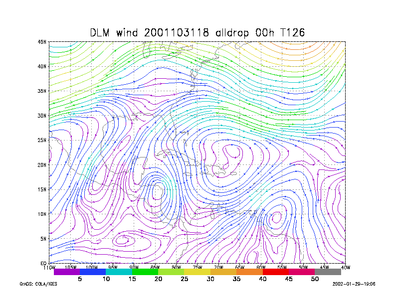
Figure 1.
NCEP 850 - 200 hPa mean wind analysis for 31 October 2001 1800 UTC
Tropical Depression #15.
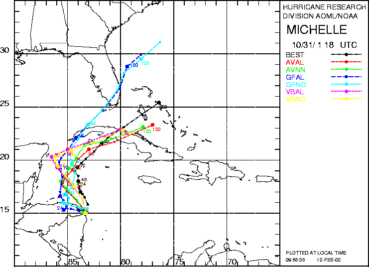
Figure 2. Track forecasts for the no dropwindsonde (NO or NN) and the all dropwindsonde (AL) runs for the AVN, GFDL, and VBAR models initialized on 31 October 2001 1800 UTC. The best track is shown in black.
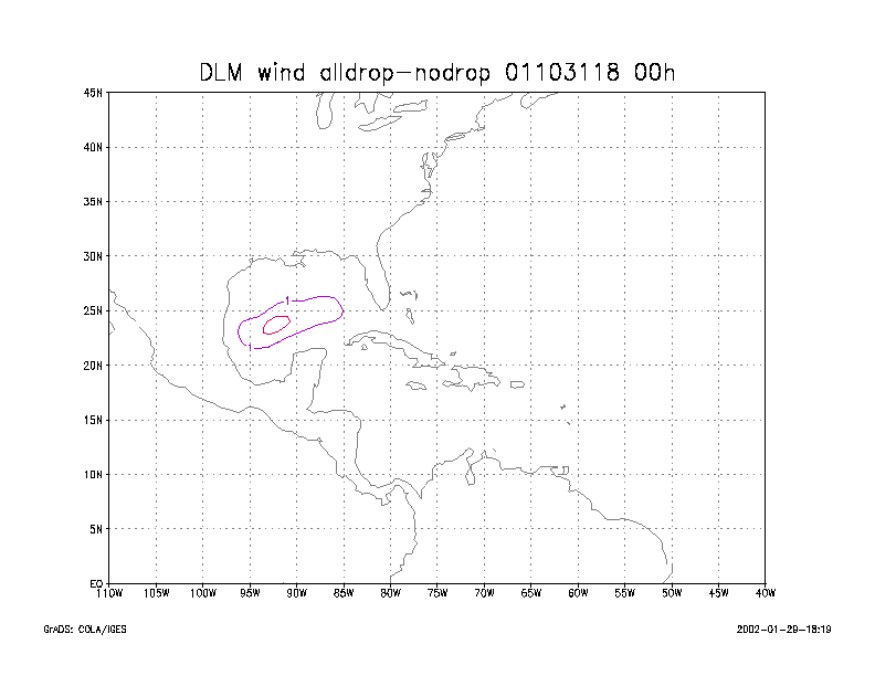
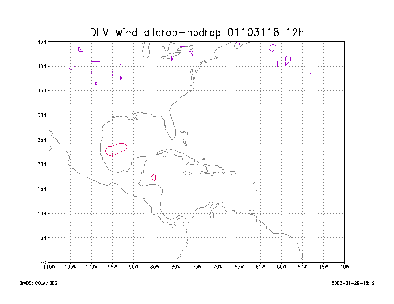
Figure 3.
Initial condition differences in the 850 - 200 hPa mean wind between the
no and all dropwindsonde cases
for 31 October 2001 1800 UTC.