Effects of Synoptic Surveillance on model forecasts for
01 October 2002 1200 UTC
Lili.
Quicktime movie of AVN DLM wind model
forecast
Quicktime movie of DLM wind data
increment
| TRACK (km) | ||||||||||||||||||||||||||||||||||||||||||||||||||||||||||||||||||||||||||||||||||||||||||||||||||||||||||||||||||||||||||||||||||||||||||||||||||||||||||||||||||||||||||||
| MODEL | 12 h | 24 h | 36 h | 48 h | 60 h | 72 h | 84 h | 96 h | 108 h | 120 h
|
| AVNN | 31. | 75. | 119. | 174. | 308. | 485. |
| AVNO | 11. | 30. | 112. | 223. | 355. | 595. |
| %IMP | 65% | 60% | 6% | -28% | -15% | -23%
|
| GFNO | 15. | 0. | 41. | 53. | 97. | 93.
| GFAL | 35. | 15. | 45. | 95. | 162. | 133.
| %IMP | -133% | und% | -10% | -79% | -67% | -43%
|
| AVNN | -55. | -74. | -89. | -40. | -6. | -6. |
| AVNO | -52. | -71. | -86. | -37. | 0. | 7. |
| %IMP | 5% | 4% | 3% | 8% | 100% | -17%
| INTENSITY (kt)
| MODEL | 12 h | 24 h | 36 h | 48 h | 60 h | 72 h | 84 h | 96 h | 108 h | 120 h
|
| GFNO | -7. | -18. | -29. | 17. | 1. | 19.
| GFAL | -1. | -18. | -35. | 10. | 8. | 14.
| %IMP | 86% | 0% | -21% | 42% | -700% | 26%
|
| SHNO | 1. | -10. | -20. | 26. | 65. | 75. |
| SHIP | -1. | -14. | -26. | 20. | 58. | 69. |
| %IMP | 0% | -40% | -30% | 23% | 11% | 8%
|
| DSNO | -10. | -21. | -31. | 15. | 54. | 20. |
| DSHP | -11. | -25. | -36. | 9. | 47. | 18. |
| %IMP | -10% | -19% | -16% | 40% | 13% | 10%
| | ||||||||||
| 01/1400 UTC 22.1N 84.0W Pinar del Rio, Cuba 2 h into the forecast | ||||||||||||||||||||||||||||||||||||||||||||||||||||||||||||||||||||||||||||||||||||||||||
| MODEL | LAT | LON | TIME | ERROR | LOCATION
|
| AVNN | 21.98 | 83.95 | 3.0 | 14.3 | Cabo Frances, Pinar del Rio, Cuba
| AVAL | 22.07 | 83.99 | 4.0 | 3.5 | Sabaia, Pinar del Rio, Cuba
| %IMP | -100% | 76%
|
| GFNO | 22.01 | 83.97 | 3.5 | 10.5 | Sandino, Pinar del Rio, Cuba
| GFAL | 21.93 | 83.95 | 4.0 | 19.6 | Cabo Frances, Pinar del Rio, Cuba
| %IMP | -33% | -87%
|
|
03/1300 UTC 29.5N 92.2W near Intracoastal City, LA 49 h into the forecast
| MODEL | LAT | LON | TIME | ERROR | LOCATION
|
| AVNN | 29.76 | 93.52 | 62.0 | 130.7 | Peveto Beach, LA
| AVAL | 29.73 | 93.51 | 65.5 | 129.1 | Peveto Beach, LA
| %IMP | -27% | 1%
|
| GFNO | 29.68 | 92.92 | 51.0 | 72.4 | Grand Chenier, LA
| GFAL | 29.75 | 93.49 | 53.5 | 127.6 | Peveto Beach, LA
| %IMP | -125% | -76%
| | |||||||||||||
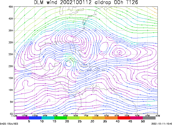
Figure 1. NCEP 850 - 200 hPa mean wind analysis for 01 October 2002 1200 UTC (Hurricane Lili).
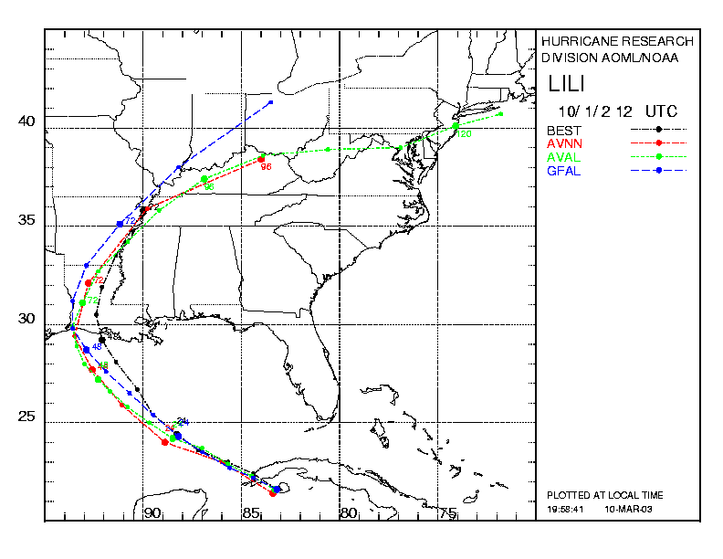
Figure 2. Track forecasts for the no dropwindsonde (NO or NN) and the all dropwindsonde (AL) runs for the AVN and GFDL models initialized on 01 October 2002 1200 UTC. The best track is shown in black.
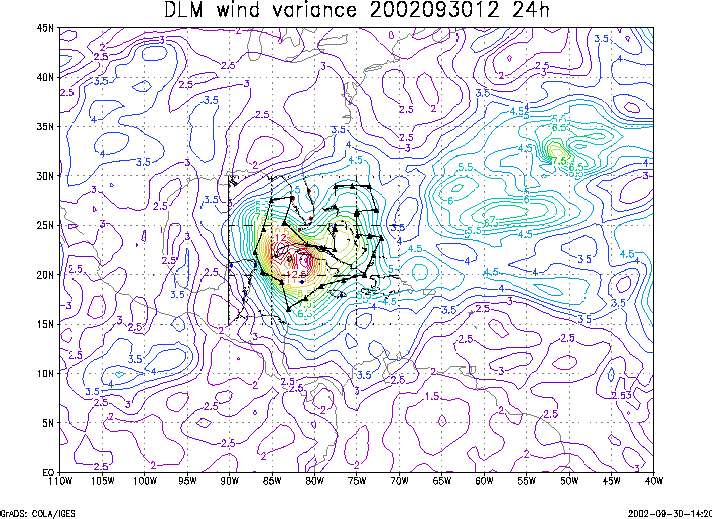
Figure 3. Ensemble perturbation variance at the nominal sampling time 01 October 2002 1200 UTC from the previous day NCEP ensemble forecast. The triangles represent the dropwindsonde locations.
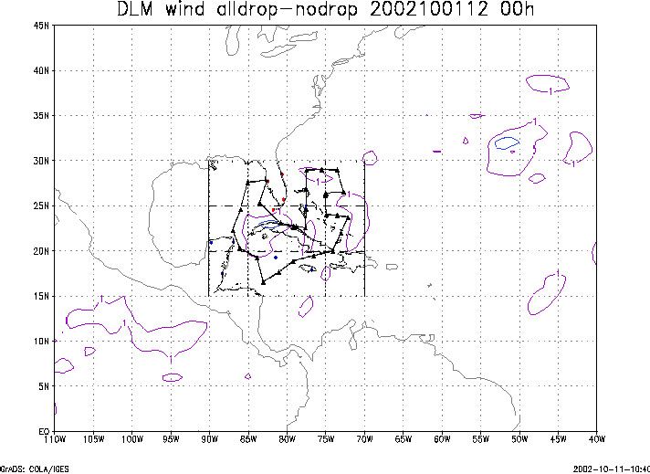
Figure 4. Initial condition differences in the 850 - 200 hPa mean wind between the no and all dropwindsonde cases for 01 October 2002 1200 UTC. The triangles represent the dropwindsonde locations.