Effects of Synoptic Surveillance on model forecasts for
26 September 2002 0600 UTC
Lili.
Quicktime movie of AVN DLM wind model
forecast
Quicktime movie of DLM wind data
increment
| TRACK (km) | ||||||||||||||||||||||||||||||||||||||||||||||||||||||||||||||||||||||||||||||||||||||||||||||||||||||||||||||||||||||||||||||||||||||||||||||||||||||||||||||||||||||||||||||||||||||||||||||||||||||||||||||||||||||||||||||||||||||||||||
| MODEL | 12 h | 24 h | 36 h | 48 h | 60 h | 72 h | 84 h | 96 h | 108 h | 120 h
|
| AVNN | 99. | 81. | 122. | 134. | 148. | 129. | 223. | 266. | 265. | 208.
| AVNO | 72. | 92. | 149. | 222. | 287. | 323. | 422. | 519. | 613. | 611.
| %IMP | 27% | -14% | -22% | -66% | -94% | -250% | -89% | -95% | -131% | -194%
|
| GFNO | 126. | 34. | 131. | 231. | 378. | 501. | 728. | 890. | 1010. | 1101.
| GFAL | 111. | 0. | 169. | 302. | 514. | 661. | 903. | 1080. | 1178. | 1229.
| %IMP | 12% | 100% | -29% | -31% | -36% | -32% | -24% | -21% | -17% | -12%
|
| AVNN | -1. | -7. | -20. | -24. | -27. | -24. | -36. | -41. | -46. | -55.
| AVNO | 0. | -5. | -20. | -27. | -28. | -21. | -33. | -38. | -44. | -56.
| %IMP | 100% | 29% | 0% | -13% | 4% | 13% | 8% | 7% | 4% | -2%
| INTENSITY (kt)
| MODEL | 12 h | 24 h | 36 h | 48 h | 60 h | 72 h | 84 h | 96 h | 108 h | 120 h
|
| GFNO | 27. | 44. | 40. | 50. | 52. | 58. | 44. | 47. | 42. | 38.
| GFAL | 37. | 49. | 24. | 32. | 48. | 55. | 44. | 31. | 29. | 37.
| %IMP | -37% | -11% | 40% | 36% | 8% | 5% | 0% | 34% | 31% | 3%
|
| SHNO | 5. | 8. | 5. | 8. | 17. | 29. | 25. | 18. | 18. | 12.
| SHIP | 6. | 10. | 7. | 10. | 17. | 30. | 25. | 19. | 18. | 12.
| %IMP | -20% | -25% | -40% | -25% | 0% | -3% | 11% | -6% | 0% | 0%
|
| DSNO | 5. | 8. | 5. | 8. | 6. | 19. | 15. | 8. | -3. | -16.
| DSHP | 6. | 10. | 7. | 10. | 7. | 19. | 15. | 9. | -3. | -16.
| %IMP | -20% | -25% | -40% | -25% | -17% | 0% | 0% | -13% | 0% | 0%
| | ||||||||||
| 01/1100 UTC 21.3N 83.0W Isle of Youth, Cuba 101 h into the forecast | ||||||||||||||||||||||||||||||||||||||||||||||||||||||||||||||||||||||||||||||||||||||||||||||||||||||||||||||||||||||||||||||||||||
| MODEL | LAT | LON | TIME | ERROR | LOCATION
|
| AVNN | 19.96 | 76.31 | 64.5 | 711.4 | Near Santiago de Cuba, Santiago de Cuba, Cuba
| AVAL | 17.84 | 76.48 | 39.5 | 783.3 | Pomfret, Jamaica
| %IMP | -68% | -10%
|
| GFNO | 21.72 | 82.57 | 79.5 | 64.4 | La Fe, La Isla de la Juventud, Cuba
| GFAL | 20.74 | 83.04 | 73.0 | 62.4 | Well offshore La Isla de la Juventud, Cuba
| %IMP | -30% | 3%
|
|
01/1400 UTC 22.1N 84.0W Pinar del Rio, Cuba 104 h into the forecast
| MODEL | LAT | LON | TIME | ERROR | LOCATION
|
| AVNN | 19.82 | 80.92 | 94.5 | 407.8 | Near Bodden Town, Grand Cayman, Cayman Islands
| AVAL | 19.82 | 77.73 | 57.5 | 698.1 | Cabo Cruz, Granma, Cuba
| %IMP | -389% | -71%
|
| GFNO | 21.94 | 84.07 | 85.5 | 19.2 | La Fe, Pinar del Rio, Cuba
| GFAL | 20.91 | 84.58 | 79.0 | 145.2 | Well offshore Cabo Frances, Pinar del Rio, Cuba
| %IMP | -35% | -656%
|
|
03/1300 UTC 22.1N 84.0W near Intracoastal City, LA 151 h into the forecast
| MODEL | LAT | LON | TIME | ERROR | LOCATION
|
| AVNN | No landfall forecast
| AVAL | No landfall forecast
| %IMP
|
| GFNO | No landfall forecast
| GFAL | No landfall forecast
| %IMP
|
| | ||||||||||||||||||||||||||||||||||
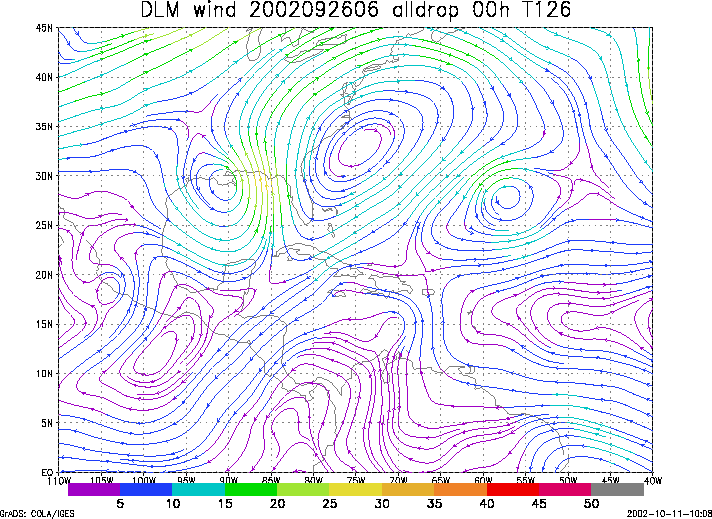
Figure 1. NCEP 850 - 200 hPa mean wind analysis for 26 September 2002 0600 UTC (Lili).
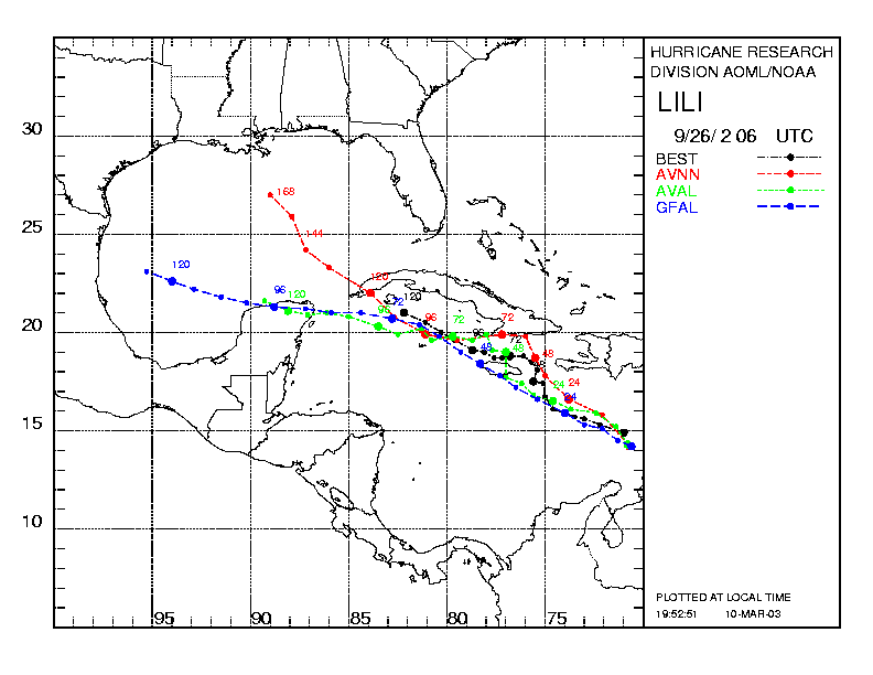
Figure 2. Track forecasts for the no dropwindsonde (NO or NN) and the all dropwindsonde (AL) runs for the AVN and GFDL models initialized on 26 September 2002 0600 UTC. The best track is shown in black.
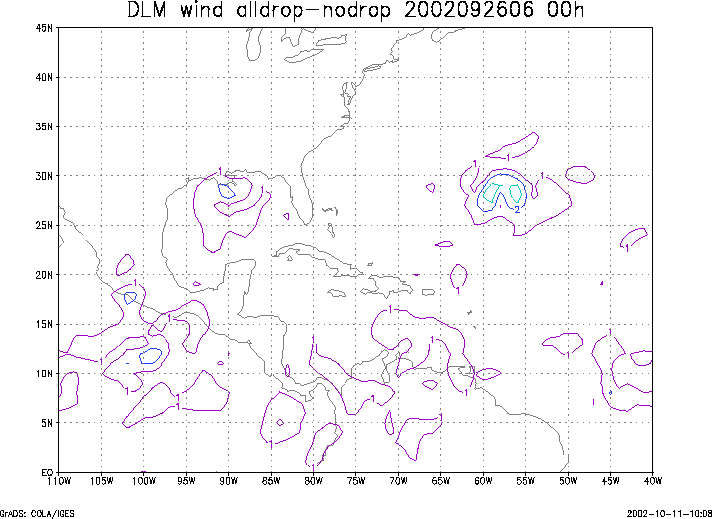
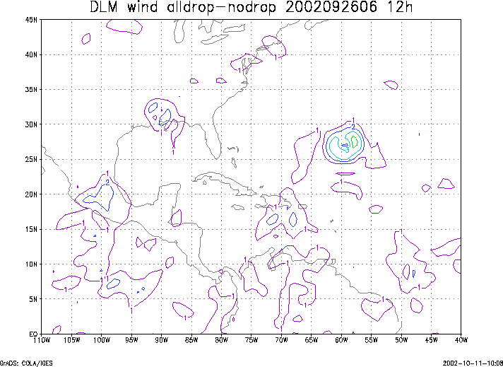
Figure 3. Initial condition differences in the 850 - 200 hPa mean wind between the no and all dropwindsonde cases for 26 September 2002 0600 UTC.