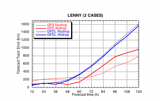
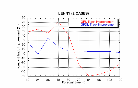
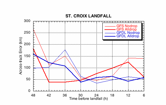
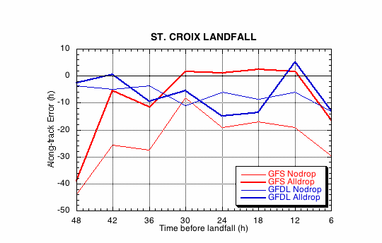
Figure 1a.
Track forecast errors for the no dropwindsonde (NO or NN) and
the all dropwindsonde (AL) runs for the GFS and GFDL models for
the Hurricane Lenny synoptic surveillance missions.
Figure 1b.
Track forecast improvements for the GFS and GFDL
models for the the Hurricane Lenny synoptic surveillance missions.
(a)
(b)
Figure 2.
Forecast errors for the landfall of Hurricane Lenny at Western
Isle of Youth, Cuba, in the (a) cross- and (b) along-track directions
for the no dropwindsonde (NO or NN) and the all dropwindsonde (AL)
runs for the GFS and GFDL models.
(a)
(b)
Figure 3.
Forecast errors for the landfall of Hurricane Lenny at
Batabano, Cuba, in the (a) cross- and (b) along-track directions for
the no dropwindsonde (NO or NN) and the all dropwindsonde (AL) runs
for the GFS and GFDL models.
(a)
(b)
Figure 4.
Forecast errors for the landfall of Hurricane Lenny at Key
West, FL, in the (a) cross- and (b) along-track directions for
the no dropwindsonde (NO or NN) and the all dropwindsonde (AL) runs
for the GFS and GFDL models.
(a)
(b)
Figure 5.
Forecast errors for the landfall of Hurricane Lenny at Cape
Sable, FL, in the (a) cross- and (b) along-track directions for
the no dropwindsonde (NO or NN) and the all dropwindsonde (AL) runs
for the GFS and GFDL models.